
Networks
| Networks - Noteć | ||
 The confluence of the nets in the Warta near Santok |
||
| Data | ||
| location | Greater Poland and Lubusz Voivodeships | |
| River system | Or | |
| Drain over | Warta → Oder → Baltic Sea | |
| Headwaters | between Koło and Włocławek | |
| muzzle | near Santok in the Warthe coordinates: 52 ° 44 ′ 8 ″ N , 15 ° 24 ′ 23 ″ E 52 ° 44 ′ 8 ″ N , 15 ° 24 ′ 23 ″ E
|
|
| length | 366 km | |
| Catchment area | 17,240 km² | |
| Left tributaries | Panna , Gąsawka , Kcyninka , Gulczanka | |
| Right tributaries | Łobżonka , Gwda , Drawa | |
| Flowing lakes | Gopło | |
| Medium-sized cities | Inowrocław | |
| Small towns | Kruszwica , Pakość , Barcin , Łabiszyn , Nakło nad Notecią , Ujście , Czarnków , Wieleń , Drezdenko | |
The Netze ( Polish Noteć ) is the main tributary of the Warta . It is 366 km long and has a catchment area of 17,240 km². The river has its source in the Greater Poland Voivodeship between Koło and Włocławek , flows through the Jezioro Gopło (Goplo Lake) south of the city of Inowrocław and flows south of the city of Schneidemühl ( Piła ) to the west.
Bydgoszcz Canal
There is a canal connection via Bromberg ( Bydgoszcz ) to the Vistula , the Kanał Bydgoski , built from 1772 to 1774 as the Bromberg Canal; it connects the Brda (Brahe) , a tributary of the Vistula, with the Netze, which flows into the Warta at Zantoch ( Santok ). Since the Warta flows into the Oder , a shipping route between the Vistula and the Oder is created through the Bromberger Canal.
Network break
The lower course of the river from the confluence of the Drawa ( Drage ) follows the Thorn-Eberswalder glacial valley , it forms the Netzebruch , a marshy break landscape that was hardly populated before the 18th century. Only at Zantoch and Driesen ( Drezdenko ) were there river crossings where fortifications were built.
In the Middle Ages a number of castles were built along the nets to secure the Polish heartland to the north. In the middle of the 13th century, the lower net was owned by Poland and owned by Neumark in Brandenburg . In the course of the German settlement in the east that began in the 12th to 14th centuries, some German settlements emerged in the swampy landscape. The majority of the new settlers of the drained quarry were German-speaking immigrants from West Prussia , which had previously been under Polish sovereignty. Their share was almost two thirds of the population. Another tenth were Saxons.
When Elector Joachim Friedrich had the Driesen Fortress built in 1603, the first planned settlement of the Netzebruch took place. In 1722 the first plans were made to drain the swamps, but until 1728 only new villages were built. There was a large population of wild boar in the swamps , the continued existence of which in the event of drainage evidently gave cause for concern. King Friedrich Wilhelm I responded to the concerns raised with the remark: Better people than pigs . The devastating floods in the Warthebruch in 1736 prompted the establishment of a drainage commission, which began its work in 1738. In 1739, hydraulic engineer and chief dike inspector Simon Leonhard von Haerlem submitted a proposal for the amelioration of both fractures, which provided for 82 families to be settled in the Netzbruch. The start of the work was prevented by the Seven Years' War . 1763 took place the surveying of the networks break and in June began with the draining, which was completed 1769th The entire work was under the direction of the domain councilor Franz Balthasar Schönberg von Brenkenhoff (1723–1780). After the First Partition of Poland , the area around the river became part of the Kingdom of Prussia as a network district in 1772 . After Prussia's defeat by Napoleon (see Peace of Tilsit ), the newly founded Duchy of Warsaw was temporarily established in 1807 , but became Prussian again after the Congress of Vienna in 1815.
Because of inadequate flood protection , several dams , dykes and ditches were built in the 19th century . The Pollychen – Zantoch flood dam was built between 1872 and 1874 and became the dividing line between the Warta and the Netzebruch. But there was still damage from floods almost every year. For this reason the Reichstag passed the Warthe and Netze Act in 1929 . As part of job creation measures for the unemployed, the dams were improved and pumping stations were built.
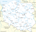
Location of the networks in Poland (since 1945)
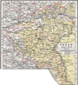
Course of the nets from Lake Goplo to its mouth
.png)

Left
literature
- Heinrich Berghaus : Land book of the Mark Brandenburg and the Markgrafthum Nieder-Lausitz in the middle of the 19th century . Volume 3, Brandenburg 1856, pp. 103-114.
- August Eduard Preuss : Prussian country and folklore or description of Prussia. A manual for primary school teachers in the province of Prussia, as well as for all friends of the fatherland . Bornträger Brothers, Königsberg 1835, pp. 20–21.
- Johann Ludwig Quandt : The land on the Net and the Neumark, as they were owned and lost by Pomerania . In: Baltic Studies , Volume 15, Stettin 1857, pp. 165–204.