
Okertalsperre
| Okertalsperre | |||||||||
|---|---|---|---|---|---|---|---|---|---|
 |
|||||||||
|
|||||||||
|
|||||||||
| Coordinates | 51 ° 51 '4 " N , 10 ° 27' 33" E | ||||||||
| Data on the structure | |||||||||
| Construction time: | - 1938-1942 - 1949-1956 |
||||||||
| Height above valley floor: | 67 m | ||||||||
| Height above foundation level : | 75 m | ||||||||
| Height above the river bed : | 59 m | ||||||||
| Height of the structure crown: | 418.2 m above sea level NN | ||||||||
| Building volume: | 140,000 m³ | ||||||||
| Crown length: | 260 m | ||||||||
| Crown width: | 8.0 m | ||||||||
| Base width: | 19 m | ||||||||
| Radius of curvature : | 78 m | ||||||||
| Slope slope on the air side : | vertical, curved at the bottom | ||||||||
| Slope slope on the water side : | perpendicular | ||||||||
| Data on the reservoir | |||||||||
| Altitude (at congestion destination ) | 416.6 m above sea level NN | ||||||||
| Water surface | 2.25 km² (225 ha) | ||||||||
| Storage space | 46,850,000 m³ | ||||||||
| Catchment area | 85 km² | ||||||||
| Particularities: |
The only arched weight wall in Germany |
||||||||

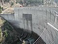
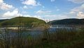
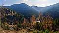
The Okertalsperre is a dam near Altenau in the Harz Mountains in the Lower Saxony district of Goslar . Your reservoir through which the Oker flows , also known as the Okerstausee , has 2.25 square kilometers of water surface at the dam target and a storage space of 46.85 million cubic meters of water. The dam is 260 meters long and up to 75 meters high. The dammed water drives the turbine of the Romkerhalle hydropower plant . The dam is operated by the Harz waterworks .
geography
location

The Okertalsperre is located in the Upper Harz in the Harz Nature Park . The storage space extends on the Oker directly north below the core town of Altenau , a little east below that of the community of Schulenberg and about 6.5 km (as the crow flies ) south-south-west above the Goslar district of Oker on the northern edge of the Harz . The two main arms of the reservoir - Altenauer Arm (southern arm or arm of the Oker) and Schulenberger Arm (southwest arm or arm of the White Water ) - are separated from each other by the elongated ridge of the Dietrichsberg (approx. 560 m above sea level ); on the slope above the east bank of the southwest arm lie the Ravensklippen. The entire dam is located in the Harz landscape protection area (district of Goslar) ( CDDA no. 321402; 2001 designated; 389.75 km² in size).
Natural allocation
The Okertalsperre lies in the natural spatial main unit group Harz (No. 38), in the main unit Upper Harz (380) and in the subunit Altenauer Bergland (380.3) in the natural area Okerbergland (380.30).
Catchment area and tributaries
The catchment area of the Okertalsperre is 85 km². Its many side arms with their strong tributaries are striking. Only roughly 40% of the inflow comes from the eponymous river Oker , which flows through the reservoir in a south-north direction and then continues north to the Weser tributary of the Aller . Other tributaries include: Schwarzes Wasser, Kellwasser , Kalbe, Große Hune , which feed the Altenauer Arm or its eastern tributaries, as well as Lange, Schalke, Riesenbach, Aeke and Große Bramke , which flow into the Schulenberger Arm or its western tributaries (pro Reservoir arm viewed approximately in a south-north direction). The former areas of influence of the Gemkenthalbachs into the Oker, whose source streams - tributaries from the Kleiner and Großer Gemkenthal - flow into an eastern tributary of the Altenauer Arm, and of the White Water, whose source streams - Lange and Schalke - feed the Schulenberger Arm, are completely covered by the reservoir . The stream from the Long Valley flows into the reservoir area near the dam from the east .
traffic
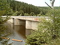
The federal road 498 , which runs parallel to the Oker between Altenau and Goslar, runs along the reservoir, crosses it on the Weißwasserbrücke and passes the dam on the western slope. At the northwest end of the road bridge to the southwest along the Südwestarm past Schulenburg by branches Zellerfeld leading national road 517 from. An asphalt forest road runs parallel to the east bank (see below ), which is closed to public motor vehicle traffic.
Technology and purpose
The Okertalsperre was built as a weight arched wall. It is likely to be the only arched weight wall in Germany. The dam is 260 m long and 75 m high above the foundation base . Its 8 m wide crown is at a height of 418.2 m above sea level. NN . The dam wall is 19 m wide at the foot. The wall has around 140,000 m³ of concrete volume.
The storage space can hold 46.85 million cubic meters of water . It has an area of 2.25 km². Its storage target is at 416.6 m and the maximum storage at 417 m .
The dam is used for power generation, low water elevation and flood protection; it is also used indirectly to produce drinking water. The mean annual runoff is 75 million m³. The water from the reservoir drives the turbine of the Romkerhalle hydropower plant .
The decision to build a weight arched wall was a special proposal from the contractors Dykerhoff & Widmann AG, Hochtief AG and Philipp Holzmann AG. They were able to prove that with this construction considerable concrete could be saved compared to an originally planned gravity dam.
The dam only has to absorb compressive forces and can therefore do without any reinforcement . In order to minimize the development of heat during the setting of the concrete, a coarse concrete was used. For this purpose, up to 40 cm large diabase stones were shaken into the relatively normal concrete . This reduced the proportion of cement. Since diabase has a relatively high density of up to 3.0 tons per cubic meter, its share also increases the weight of the concrete, which gives the wall additional stability.
Valley side of the dam wall with suicide safety net

Overflows at the Okertalsperre
Board with technical data on the Oker dam


history
overview
The construction of the Oker dam was tackled by the Harz waterworks between 1938 and 1942. For this purpose, the valley roads were first relocated to the western and northern bank and the two road bridges ("Weißwasserbrücke" and "Bramke Bridge") were built. Soviet prisoners of war were also used, whose graves are located in the Altenau cemetery. Construction was interrupted in 1942 because of the war and the resulting priorities. The dam itself was built from 1952 to 1956. Further construction also became urgent after floods occurred in the snowy winter of 1946/47, especially in Wolfenbüttel and Braunschweig . During the construction, the forest workers settlement in Unterschulenberg had to be abandoned; it was rebuilt west of the storage space on the Wiesenberg. In years with little rain, the water level of the dam can drop so much that the remains of individual foundation walls and the old valley road with its bridges become visible.
Photos from the construction

Oker dam under construction, around 1954/55

Okertalsperre under construction
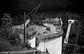
Okertalsperre under construction

Weißwasserbrücke, around 1954/55
Renewed Weißwasserbrücke (right), 2014


Monument protection
The architect Carl Bauer played an essential role in the planning of the many ancillary buildings in particular, but probably also on the main dam. As a building completed in 1956, the entire complex has a striking number of well-preserved stylistic elements from the 1950s, which is particularly noticeable in the winch house east of the dam, the Café Okerterrasse and the operating building of the Romkerhalle power plant. For this reason, the Okertalsperre was placed under monument protection at the end of the 1990s.
tourism
A liner for tourists operates on the Okerstausee from the beginning of March to the beginning of January (only on weekends in the off-season). This liner connection is the highest (above sea level ) in Lower Saxony. In addition, the reservoir is used by numerous private, non-motorized watercraft in the warm season. Bathing and diving is permitted outside of cordoned-off areas, for example in parts near the dam. In winter, ice bathing events take place when the ice is thick enough .
The Oker reservoir can be completely circled on foot and with non-motorized vehicles on roads and paths. Between the dam and the main dam, there is an almost completely paved roadway that is used by cyclists, inline skaters and roller skiers; only the path between the dam and Altenau is not paved. On the federal highway 498 there is heavy motorcycle traffic on weekends in the summer months (north approach to Torfhaus ). Here lie along the dam several catering businesses: a restaurant in Altenauer district Gemkenthal that near the White Water Bridge standing Brückenschänke and located at the dam Café Okerterrasse . There is a campsite at the root of the reservoir to the Oker.

Ship of the line on the Oker reservoir, Weißwasserbrücke in the background

Oker reservoir when the water level is low

Oker in the Oker reservoir when the water level is low

Branch of the Oker reservoir when the water level is low

Temporarily flooded bridge in the Oker reservoir when the water level is low
Waterfall and power station Romkerhalle


Fish fauna
The Okerstausee is mainly a salmonid water with brook trout , grayling , brook , rainbow and lake trout . There are also pike , pikeperch , large perch , eels , eel tadpoles , carp , tench and numerous white fish . Guest cards are issued for fishing.
Facilities of the main dam

Bottom outlet
The bottom outlet of the Okertalsperre is located at the lowest point in the valley and can be reached via the old valley road from Romkerhalle. It consists of a DN 1200 pipeline with a rake , inspection seal and drop-weight flap on the water side and a plunger valve on the air side. Its output is - depending on the water level - around 15 m³ / s. The inspection lock consists of a contactor , which can be lowered from the top of the wall in front of the water side along rails in front of the inlet of the bottom outlet. The contactor and the associated winch car are kept in a wooden shed at the eastern end of the wall. Apart from regular functional tests, the bottom outlet is only activated during floods or during the annual turbine inspection.
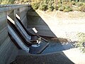
Flood relief system
The flood relief system works on the principle of a siphon . It is located in the eastern third of the dam and consists of a total of 8 jacks with a cross-section at the apex of 1.5 m², which automatically go into operation when the full dam of 416.60 m above sea level is reached. Each lift achieves up to 15 m³ / s, so that all 8 lifts together can produce 120 m³ / s. In order to be able to dispense smaller floods in a better dosed manner, two siphons are installed 10 cm lower; Furthermore, all lifters are provided with ventilation valves which, when open (ventilated), can significantly reduce the lifting effect, which roughly halves the flow. The flood relief system was only used twice in regular operation, namely in 1981 and 1994.

Winch house with upstream rail (right), inlets for flood relief (left)

Winch house with upstream rail track

Winch inside the winch house

Ventilation valves of the siphon flood discharge

Cross-sectional sketches of the dam, photographed from the information board there


Process water extraction with pressure tunnel and winch house

Usually the water from the Oker dam is taken from the service water line. This consists of a 1.1 km long pressure tunnel that begins on the eastern slope just before the dam and the water leads through the Ahrendsberg to Romkerhalle. The tunnel has a circular cross-section with a diameter of 2.0 m. In front of the tunnel opening there is a rake that can be pulled up from the winch house on a railroad for cleaning purposes. From the winch house, an inspection lock in the form of a contactor can also be placed on the same track in front of the tunnel inlet. Then the tunnel can be emptied and checked. The tunnel ends shortly before the Romkerhalle power station; the last 30 m consist of an exposed steel pressure pipe DN 1600, which leads the water into the power plant. In the last third of the pressure tunnel there is a water lock in the form of a shaft structure, the opening of which is very hidden in the area of the Ahrendsberg. The capacity of the tunnel and power plant is a maximum of about 8.1 m³ / s.
Stilling basin
Both the bottom outlet and the flood relief system flow into a 110 m long stilling basin , which was built at the foot of the wall in the original river bed of the Oker. A water cushion of at least 3.50 m high is available here during operation, with which the high kinetic forces of the water arriving at high speed are considerably reduced. If neither the bottom outlet nor the flood relief is in operation (which is usually the case), the stilling basin can run empty through a small opening.
Other facilities
Pre-lock
| Okertalsperre, pre-lock | |||||||||
|---|---|---|---|---|---|---|---|---|---|
 |
|||||||||
|
|||||||||
|
|||||||||
| Coordinates | 51 ° 49 ′ 22 " N , 10 ° 26 ′ 47" E | ||||||||
| Data on the structure | |||||||||
| Construction time: | 1953-1954 | ||||||||
| Height of the barrier structure : | 20.0 m | ||||||||
| Building volume: | 16,000 m³ | ||||||||
| Crown length: | 100 m | ||||||||
| Base width: | 14.0 m | ||||||||
| Slope slope on the air side : | aslant | ||||||||
| Slope slope on the water side : | perpendicular | ||||||||
| Data on the reservoir | |||||||||
| Altitude (at congestion destination ) | 415 m above sea level NN | ||||||||
| Water surface | 12 ha | ||||||||
| Storage space | 520,000 m³ | ||||||||
The pre-dam of the Okertalsperre is equipped with a weight dam that is 20.0 m high and 100 m long. The structure can hold up to 520,000 m³ of water and is primarily used for the water quality in the main dam. The permanent damming (max. 15 m water height at the dam wall) enabled the development of a wetland in the Kellwassertal . Only when the water level in the Oker reservoir is very high are the dam and pre-dam at the same water level. Then the water level in the pre-dam can rise by up to 1.60 m.
Pre-lock, forepink side
Pre-lock on the air side when the water level in the main lock is low


Romkerhalle hydropower plant

About 1.1 km (as the crow flies) northeast below the Okertalsperre is the Romkerhalle hydropower plant near Romkerhalle. Its Francis turbine is powered by water that is fed from the dam through a pressure tunnel, followed by a short pipeline. The power plant, which went into operation in 1956, has an expansion capacity of 4.14 MW. The gradient resulting from the pipeline is up to 80 m, the maximum flow rate of the turbines 8.1 m³ per second and the average annual work 12.5 million kWh per year. The power plant is operated as a storage power plant for around eight hours a day. This temporarily interrupted power plant operation results in strong water level changes in the Oker up to the equalization basin. The power station drains directly into the Oker river bed; This is where the river's whitewater stretch begins , which uses the intermittent power plant operation for canoeing .
Oker Grane Stollen

Via the 7.4 km long Oker-Grane tunnel, whose inlet is at Romkerhalle in the southeast and whose outlet is on the east bank of the Granetalsperre in the northwest, water from the Okertalsperre (power station or bottom outlet) can be channeled into the Granetalsperre, where it is used for drinking water can be processed. The Granetalsperre itself has only a relatively small catchment area and is dependent on further tributaries for its drinking water supply. The Oker Grane gallery was built from 1968 to 1970. On his way he crosses the valley of the Abzucht and that of its tributary Gose . In the event of increased drainage, it can also drain water from both streams and feed it to the Granetalsperre.
Equalization basin of the Okertalsperre
| Equalization basin of the Okertalsperre | |||||||||
|---|---|---|---|---|---|---|---|---|---|
 |
|||||||||
|
|||||||||
|
|||||||||
| Coordinates | 51 ° 52 ′ 11 " N , 10 ° 28 ′ 13" E | ||||||||
| Data on the structure | |||||||||
| Construction time: | 1953-1954 | ||||||||
| Height of the structure crown: | 18 m | ||||||||
| Building volume: | 7800 m³ | ||||||||
| Crown length: | 78 m | ||||||||
| Slope slope on the air side : | aslant | ||||||||
| Slope slope on the water side : | perpendicular | ||||||||
| Data on the reservoir | |||||||||
| Altitude (at congestion destination ) | 313 m above sea level NN | ||||||||
| Water surface | 2 ha | ||||||||
| Storage space | 204,000 m³ | ||||||||
The equalization basin , located about 2 km below the Oker Dam and 1 km below the Romkerhalle hydropower plant, is equipped with a gravity dam that is 18 m high and 78 m long. The compensation basin can hold up to 204,000 m³ of water and is mainly used to collect water from the intermittent operation of the power plant and to discharge it into the underwater as a steady drain. Up to the northern edge of the Harz Mountains, turbines are driven by small hydropower plants located on the Oker. Similar to the Oker reservoir, when the water surface is undisturbed, a very smooth water surface forms on the reservoir, on which the surrounding landscape is clearly reflected. Because of the sheltered location of the equalization basin, this phenomenon occurs quite often there.

Equalization basin of the Okertalsperre, dam wall, valley side

Equalization basin of the Okertalsperre, impact body


Sewer

In order not to unnecessarily pollute the water in the dam, the wastewater from Altenau and Schulenberg is led in a separate sewer pipe around the Oker dam to the Goslar-Oker sewage treatment plant.
See also
literature
- Martin Schmidt : Dams in the Harz, East and West Harz . Updated by Rainer Tonn. 9th edition. Paper plane, Clausthal-Zellerfeld 2012, ISBN 978-3-86948-251-4 .
- Peter Franke, Wolfgang Frey: Dams in the Federal Republic of Germany . Systemdruck, Berlin 1987, ISBN 3-926520-00-0 .
- German Dam Committee (Ed.): Dams in Germany , SpringerVieweg, Wiesbaden, 2013
Movie
- When the dams came into the Harz , documentary, Germany, 2011, 43:30 min., Script and director: Hanna Legatis , production: NDR , series: Our story , first broadcast: August 3, 2011, NDR, summary , on television series. de
Web links
- The Oker Reservoir and current reservoir data
- The Okertalsperre , on harzlife.de
- Okertalsperre. In: Structurae
- The Okertalsperre - Harz reservoir near Schulenberg , on harz-region.de
Individual evidence
- ↑ a b c d e f g h Okertalsperre board , on commons.wikimedia.org
- ↑ a b c d e f g h i j k l m n o p q The Okertalsperre , on harzwasserwerke.de
- ↑ a b c d e German Talsperrenkomitee (ed.): Talsperren in Deutschland , SpringerVieweg, Wiesbaden, 2013
- ↑ Map services of the Federal Agency for Nature Conservation ( information )
- ↑ Jürgen Spönemann: Geographical Land Survey: The natural spatial units on sheet 100 Halberstadt. Federal Institute for Regional Studies, Bad Godesberg 1970. → Online map (PDF; 4.7 MB)
- ↑ Günther Hein & Claudia Küpper-Eichas, Armaments as a way out of the crisis? Work and economy in the Upper Harz during the National Socialism. - Montanregion Harz 7, publ. Dt. Mining Mus. 146, Bochum, 2006
- ↑ The Okertalsperre ran aground , Hannoversche Allgemeine Zeitung , November 30, 2011, on haz.de
- ↑ Oliver Stade: The new Schulenberg is shaped by the Bauhaus , Goslarsche Zeitung of August 24, 2019
- ↑ Angler-Info - Angler maps for… Okertalsperre… , accessed on October 1, 2012, on harzwasserwerke.de
- ↑ Harzwasserwerke GmbH (ed.): Okertalsperre , information brochure of the operator, 10/1997
- ↑ a b Harzwasserwerke GmbH (ed.): Water with energy , information brochure, October 2008, p. 15
- ↑ Justus Teicke: Flood protection for Goslar, a discharge point on the Wintertalbach in the mountain valley Goslarer Bergkalender , 2015, Verlag Goslarsche Zeitung Karl Krause, Goslar 2014