Okres Semily
| Okres Semily | |
|---|---|
| Kraj | Liberecký kraj |
| surface | 698.93 km² |
|
Inhabitants • Population density |
73,882 ( January 1, 2019 ) 107 inhabitants / km² |
|
Municipalities • of which cities • of which Městyse |
65 9 0 |
| LAU 1 | CZ0514 |
|
Vehicle registration number (issued until 2001) |
SM |

|
|
The Okres Semily (German: Semil District ) was a regional authority in Liberecký kraj (Reichenberg region) in the Czech Republic . The Okresy were roughly comparable with the districts in Germany, the district administrations were dissolved on December 31, 2002 . The district is located in the south-eastern part of northern Bohemia and extends from the Bohemian Paradise to the Giant Mountains .
73,882 inhabitants (as of January 1, 2019) live on 699 km² in 65 municipalities and 208 districts, nine of which are cities in which 60% of the population lives. What is special about the district is that it is not the town of Semily that has the most inhabitants, but Turnov .
A total of 17,000 companies are registered in the district. Industry still plays the biggest role. The textile industry that was once predominant today hardly plays a role in contrast to mechanical engineering, the food and glass industries. 51% of the population are gainfully employed, gross wages are below the average for the district and the state, and unemployment is 6.5%.
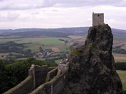
Tourism is an important year-round source of income. Krkonoše with the recreation centers Harrachov , Benecko , Rokytnice nad Jizerou , Vysoké nad Jizerou are not only winter sports areas, but also venues for international sporting events. Český Ráj is a nature reserve with rare plants and historical buildings such as the medieval Trosky Castle with the legendary Kozákov Mountain, a place where precious stones were found. The sandy rocky landscapes, an Eldorado for climbers, are also typical of Český ráj . The Bozkovské jeskyně (Bozkov Dolomite Caves ) are a world rarity .
cities and communes
Benecko - Benešov u Semil ( Beneschau b.Semil ) - Bělá ( Biela ) - Bozkov ( Boskau ) - Bradlecká Lhota ( Lhota Bradletz ) - Bukovina u Čisté ( Bukowina b. Tschiest ) - Bystrá nad Jizerou ( Bistra ad Iser ) - Čistá u Horek ( Tschiest ) - Háje nad Jizerou ( Haje ) - Harrachov ( Harrachsdorf ) - Holenice ( Holenitz ) - Horka u Staré Paky ( Falkendorf ) - Horní Branná ( Brennei ) - Hrubá Skála ( Großskal ) - Chuchelna - Jablonec nad Jizerou ( Jablonetz ) - Jesenný ( Jesen ) - Jestřabí v Krkonoších ( Jestrabi ) - Jilemnice ( Starkenbach ) - Kacanovy ( Kazanów ) - Karlovice ( Karlowitz ) - Klokočí ( Klokotsch ) - Košťálov ( Koschtialow ) - Kruh ( Kruch ) - Ktová ( Ktowa ) - Levínská Olešnice ( Lewiner Oels ) - Libštát ( Liebstadtl ) - Lomnice nad Popelkou ( Lomnitz ad Popelka ) - Loučky ( Loutschek ) - Martinice v Krkonoších ( Merzdorf ) - Mírová pod Kozákovem ( Mirowa ) - Modřišice ( Modschitz ) - Mříčná ( Wemerschitz ) - Nová Ves nad Popelkou ( Neudorf adPopelka ) - Ohrazenice u Turnova ( Wochrasenitz ) - Olešnice ( Woleschnitz ) - Paseky nad Jizerou ( Pasek ) - Peřimov ( Perschimov ) - Poniklá - Přepeře ( Pschepersch ) - Příkrý ( Pschikri ) - Radostná pod Kozákovem - Rakousy ( Rakous ) - Rokytnice nad Jizerou ( Rochlitz ad Iser ) - Roprachtice ( Ruppersdorf ) - Rovensko pod Troskami ( Rowensko b. Turnau ) - Roztoky u Jilemnice ( Rostok b. Starkenbach ) - Roztoky u Semil ( Rostok b.Semil ) - Semily ( Semil ) - Slaná - Stružinec ( Struschinetz ) - Studenec ( Studenetz ) - Svojek ( Swojek ) - Syřenov ( Sirschenow ) - Tatobity ( Tatobit ) - Troskovice ( Troskowitz ) - Turnov ( Turnau ) - Veselá ( Wessela ) - Víchová nad Jizerou ( Wichau ) - Vítkovice ( Witkowitz ) - Všeň ( Weschen ) - Vyskeř ( Wiskersch ) - Vysoké nad Jizerou ( Hochstadt ) - Záhoří ( Sahorsch ) - Žernov ( Schernow )
Individual evidence
- ↑ http://www.uir.cz/okres/3608/Semily
- ↑ Český statistický úřad - The population of the Czech regions and counties as of January 1, 2019 (XLSX)
Web links
Coordinates: 50 ° 37 ' N , 15 ° 23' E
