
Oroville (California)
| Oroville | |||
|---|---|---|---|
| Nickname : City of Gold | |||
 Old Town of Oroville (2010) |
|||
| Location in California | |||
|
|||
| Basic data | |||
| Foundation : | January 3, 1906 | ||
| State : | United States | ||
| State : | California | ||
| County : | Butte County | ||
| Coordinates : | 39 ° 31 ′ N , 121 ° 33 ′ W | ||
| Time zone : | Pacific ( UTC − 8 / −7 ) | ||
| Residents : | 15,546 (as of 2010) | ||
| Population density : | 490.4 inhabitants per km 2 | ||
| Area : | 31.8 km 2 (approx. 12 mi 2 ) of which 31.7 km 2 (approx. 12 mi 2 ) is land |
||
| Height : | 51 m | ||
| Postcodes : | 95940, 95965, 95966 | ||
| Area code : | +1 530 | ||
| FIPS : | 06-54386 | ||
| GNIS ID : | 0277570 | ||
| Website : | www.cityoforoville.org | ||
| Mayor : | Linda Dahlmeier | ||

Oroville is a small town with City status and a population of approximately 15,500 in Butte County , California . It is located about 100 kilometers north of Sacramento in the northern Central Valley , where the Feather River from the Sierra Nevada reaches the plains. The city was founded in 1849 during the Californian gold rush as Ophir City , the current name means "Gold City ". Oroville was at times the most important gold rush town in California.
geography
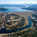
The city lies at 51 m above sea level below Lake Oroville , which is dammed by the Oroville Dam . It is the highest dam in the USA. Today the confluence of the three headwaters of the Feather River lies in the reservoir. To the north of the city lies the characteristic Table Mountain , a plateau that actually consists of two truncated cones and was formed from a former volcano. It is a symbol of the city and is also shown on the city seal.
Oroville is served by the California state highway CA-70 in a north-south direction and the smaller CA-162 from east to west. The regional airport Oroville Municipal Airport is located southwest of the town. The Union Pacific Railroad , which is now only used for freight traffic and runs along the Feather River over the Sierra, runs through the town.
The mountains above Oroville belong to the Plumas National Forest , a National Forest under management of the United States Forest Service , the reservoir and its banks are as Lake Oroville State Recreation Area reported, the Feather River below the town stands as Oroville Wildlife Area under nature conservation .
history
The region around Feather River and American River was originally settled by the Maidu , an Indian people from the Penuti language family . They lived as hunters and gatherers , and acorn flour was a main focus of their diet . Their weaving technique for baskets and other containers was highly developed.
Oroville began as a gold rush settlement called Ophir City in 1849. Above the Middle Fork of the Feather River, John Bidwell had already found larger gold deposits in July 1848, and thus very early in the California gold rush, and set up his Camp Bidwell's Bar - bar stands for a sandbank on the river , not for a catering business. Bidwell's Bar became the first county seat of Butte County, established after California was founded . When the gold deposits were exhausted after a few years, the prospectors moved down the river to Ophir City to the much more abundant gold deposits. The county seat also moved to the settlement now renamed Oroville in 1856.
The place with the favorable length on the edge of the plain became the economic center for the region and the gold rush settlements in the mountains. Contributing to this was that the former slave James P. Beckwourth discovered the Beckwourth Pass in 1850 , the lowest pass across the Sierra, and that his Beckwourth Trail ran from Reno , Nevada along the Feather River over the mountains to Oroville and on to Marysville . In 1856 six stagecoaches drove south to Marysville with a connection to Sacramento, one daily north to the Central Valley to Shasta (today's Redding), three to the gold fields north of the city, and one each up the river to the gold fields at Bidwell's Bar, to the east and Forbestown; and to the southeast and Bangor . Every two days a long-distance connection drove over the mountains. In 1857, Oroville was the most populous gold rush town in California with two theaters, three banks, a concert hall, a racecourse and innumerable hotels. In the same year, a ship connection with a paddle wheel steamer between Oroville and Sacramento began operations. Due to the increasing siltation of the river, the operation was stopped again in 1862.
As part of the gold rush, prospectors from the eastern United States, but also thousands of Chinese immigrants, came to Oroville. They settled on the other bank of the river in their Chinatown called Lava Beds , the largest purely Chinese gold rush settlement of its time and the second largest Chinatown after that of San Francisco . In the autumn of 1873 the Chinese settlement consisted of 150 wooden houses, twelve tents and one stone building, the general store . Up to 10,000 Chinese are said to have lived in Lava Beds ; in 1863 they built the preserved Oroville Chinese Temple as a religious and social center.
Until the 1880s, gold was still washed manually or with the help of channels , later gold dredges were used for the first time on the Feather River: floating dredges that fed sand and gravel to mechanical gold washing systems. This technique later caught on and is still used today on a large scale or in miniaturized form. After gold mining ended, Oroville shrank massively and ranching and forestry on the slopes of the Sierra became the new foundation of the city.
After the turn of the century, the Western Pacific Railroad built a rail link along the Feather River across the Sierra. It was completed in 1905 and used existing narrow-gauge railways. In 1911, Ishi , the last of the Yahi people , was found outside of Oroville . The anthropologist Alfred Kroeber won his trust, learned the language and gained insights into the culture of the people who were already considered extinct.
Oroville Airport was created in 1936 and expanded by the Works Progress Administration in 1941 as part of the New Deal . During World War II it served as the Oroville Army Air Field and was greatly expanded. In 1947 he went back to civil administration.
The Oroville Dam was completed in 1968. It is the tallest dam in the United States and is still one of the tallest dams in the world. The reservoir is used to power Northern California and has become a popular recreational area. It flooded the river as far as the confluence of the spring arms of the Feather River and almost all of the historic gold fields. Bidwell's Bar and several other gold rush settlements now lie at the bottom of the lake. In 1975 there was a major earthquake measuring 5.7 on the Richter scale in the region, and the dam held up. As a result, the requirements for dams in the United States were significantly tightened and a project at Auburn on the American River was abandoned.
economy
Today Oroville lives mainly from tourism . The Oroville reservoir offers a wide range of water sports and fishing . The banks and the adjacent mountains are used for hiking, camping and hunting. There are two casinos in town . The largest employers are the Butte County Administration and Butte College. Further branches of industry are the cultivation of fruit and vegetables and forestry.
Demographics
The 2010 census showed a population of 15,546. This was an increase of around 2,500 people compared to the year 2000, when around 13,000 people were still living in Oroville according to the state of the census at that time . Around three-quarters of the population were white people of European descent. Their share is thus above the average for the state of California, but has only decreased by around two percent within ten years. The group of Latinos made up twelve percent of the urban population. Citizens of Asian origin were represented with a share of eight percent, while Afro-Americans were a minority with just under three percent of the population. Their share is thus well below the California and national American averages. The number of households was 5646, while for every 100 women there were 93.7 men. The median age of the population of Oroville was 31.5 years.
Attractions

Oroville is home to the mother orange tree, the oldest of all Northern California orange trees. It was planted at Bidwell's Bar in 1856 and started growing and growing citrus fruits in Northern California. In 1968 it was transplanted to Oroville because of the impending flooding by the reservoir. The old Bidwell Bar Bridge , the bridge over the river there, was also rescued from Bidwell's Bar . It was built in 1855 and is considered the oldest surviving suspension bridge in California and is now only used for pedestrian traffic at the Kelly Ridge marina in the south of the reservoir.
The new Bidwell Bar Bridge from 1965 leads California State Route 162 over a branch of the reservoir to the east of the city. With a span of 338 m, it is one of the longest suspension bridges in the western United States, and with a height of 191 m above the valley floor, it was the third highest suspension bridge in the world when it opened.
The Chinese Temple was built in 1863 as a religious and social center and had rooms for meditation and religion, as well as for community purposes. It was abandoned in 1907 and has served as a museum since 1949. However, it is still available for religious ceremonies on an irregular basis.
The CF Lott Home was built in the Victorian style in 1856 and was owned by the eponymous family until 1961. The building and the associated garden are now accessible as a museum.
The Butte County Pioneer Memorial Museum commemorates the gold digging and pioneering days as well as the Indians of the region.
Picture gallery
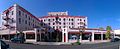
Oroville Inn (2012)

New Bidwell Bar Bridge (2006)
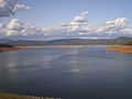
Lake Oroville (2010)
Dam (2010)

Old Customs House (1984)

Aerial view of Oroville Municipal Airport (1998)


Personalities
Sons and Daughters of Oroville
- Doug LaMalfa (* 1960), American politician
- Jack Yerman (born 1939), American athlete
Associated with Oroville
- Aaron Rodgers (born 1983), American football player
literature
- Donna Lenhoff, James Lenhoff: Oroville California . Arcadia Publishing, 2001, ISBN 0738518549
Web links
Individual evidence
- ↑ Oroville (California) in the Geographic Names Information System of the United States Geological Survey
- ↑ Unless otherwise stated, this chapter is based on: Mildred Brooke Hoover, Douglas E. Kyle: Historic spots in California . Stanford University Press, 2002, ISBN 9780804744829 . Pages 39-40
- ↑ Donna Lenhoff, James Lenhoff: Oroville California . Arcadia Publishing, 2001, ISBN 0738518549 . Page 7
- ^ Josephine D. Lee, Imogene L. Lim, Yuko Matsukawa: Re / collecting early Asian America - essays in cultural history . Temple University Press, 2002, ISBN 9781566399647 . Page 39
- ↑ a b cityofroroville.org: Chinese Temple ( Memento of the original from September 19, 2010 in the Internet Archive ) Info: The archive link was inserted automatically and has not yet been checked. Please check the original and archive link according to the instructions and then remove this notice.
- ^ Militarymuseum.org: Oroville Army Air Field
- ^ Carl-Henry Geschwind: California earthquakes: science, risk, & the politics of hazard mitigation . JHU Press, 2001, ISBN 0801865964 . Page 219
- ↑ Oroville Chamber of Commerce: Community ( page no longer available , search in web archives ) Info: The link was automatically marked as defective. Please check the link according to the instructions and then remove this notice.
- ↑ United States Census 2010 ( Memento from February 20, 2011 in the Internet Archive )
- ^ Bidwell Bar Bridge. In: Structurae
- ↑ Eric Sakowski: Bidwell Bar Bridge. In: HighestBridges.com. December 5, 2010, accessed October 21, 2014 .
- ↑ cityofroville.org: CF Lott Home ( Memento of the original from September 19, 2010 in the Internet Archive ) Info: The archive link was inserted automatically and has not yet been checked. Please check the original and archive link according to the instructions and then remove this notice.
- ↑ cityofroville.org: Pioneer History Museum ( Memento of the original from December 10, 2011 in the Internet Archive ) Info: The archive link was inserted automatically and has not yet been checked. Please check the original and archive link according to the instructions and then remove this notice.
| Cities |
 |
|
| Towns | ||
| CDPs |
Bangor | Berry Creek | Butte Creek Canyon | Butte Meadows | Butte Valley | Cherokee | Clipper Mills | Cohasset | Concow | Durham | Forbestown | Forest Ranch | Honcut | Kelly Ridge | Magalia | North | Oroville East | Palermo | Rackerby | Richvale | Robinson Mill | South Oroville | Stirling City | Thermalito | Yankee Hill |
|
|
unincorporated communities |
Centerville | Cresta | DeSabla | Dodge Place | Helltown | Inskip | Irish Town | Lomo | Lovelock | Mineral Slide | Powellton | Pulga |