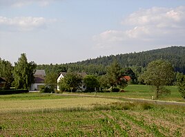
Pirk (Oberviechtach)
|
Pirk
City of Oberviechtach
Coordinates: 49 ° 31 ′ 57 ″ N , 12 ° 28 ′ 7 ″ E
|
|
|---|---|
| Height : | 655 m |
| Residents : | 55 (Jan 16, 2013) |
| Postal code : | 92526 |
| Area code : | 09677 |
|
Pirk (Oberviechtach)
|
|
Pirk is a district of the town of Oberviechtach in the Upper Palatinate district of Schwandorf in Bavaria .
Geographical location
The village of Pirk is located on an open plateau at the foot of the 750 m high Stangenberg. To the north on the slope of the Stangenberg there is a silver mine, which reminds us that numerous and intensive attempts were made here on the Stangenberg in the 16th century to mine gold and silver without ever being successful.
history
Pirk was mentioned in writing for the first time in the sample report from 1587. Pirk belonged to the parish Pullenried and the parish of Langau .
In the course of the parish edict in July 1818, the formation of a separate parish Pirk was initially planned. Because of the low population of Pirk (14 families), the government of the Regenkreis ordered a connection to the municipality of Oberlangau , which in turn was incorporated into Mitterlangau (later municipality of Langau) in March 1830 .
As of March 23, 1913 (Easter), Pirk was listed as part of the Pullenried parish with 17 houses and 112 inhabitants. On December 31, 1969, the municipality of Langau had 397 inhabitants. In addition to Ober- , Mitter- and Unterlangau, it also included Pirk, Brandhäuser , Tannermühle , Gütting , Waldhäusl and Bockhaus. On December 31, 1990 Pirk had 64 inhabitants and belonged to the parish Pullenried and the municipality of Oberviechtach.
literature
- Heribert Batzl (Ed.): The Oberviechtach district in the past and present. Publishing house for authorities and economy R. Alfred Hoeppner, Aßling / Obb. and Munich 1970.
Individual evidence
- ↑ Oberviechtach residents' registration office, reference date: January 16, 2013
- ^ A b c Bruno Bauer: On the history of the communities Langau, Pullenried, Wildeppenried. In: Heribert Batzl (ed.): The district of Oberviechtach in the past and present. Publishing house for authorities and economy R. Alfred Hoeppner, Aßling / Obb. and Munich 1970, p. 133.
- ↑ Fritsch hiking map Schönseer Land, scale 1: 35000
- ↑ Erich Mathieu: On the history of the city of Oberviechtach. In: Heribert Batzl (ed.): The district of Oberviechtach in the past and present. Publishing house for authorities and economy R. Alfred Hoeppner, Aßling / Obb. and Munich 1970, p. 66.
- ↑ Emma Mages: Oberviechtach . In: Historical Atlas of Bavaria , part of Old Bavaria . Series I, issue 61. Komm. Für Bayerische Landesgeschichte, Munich 1996, ISBN 3-7696-9693-X , p. 212 ( digitized version ).
- ^ Diocese of Regensburg (ed.): Register of the Diocese of Regensburg . ed. i. A. Sr Excellency of the Most Revered Bishop Dr. Antonius von Henle from the Episcopal Ordinariate Regensburg. Regensburg 1916, p. 382 ( digitized version ).
- ↑ Manfred Müller (Ed.): Register of the diocese of Regensburg. Verlag des Bischöflichen Ordinariats Regensburg, 1997, p. 550

