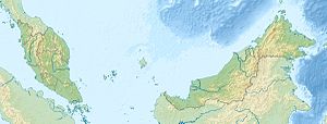
Pulau batik
| Pulau batik | ||
|---|---|---|
| Location of Pulau Batik in Darvel Bay | ||
| Waters | Celebes Sea | |
| Geographical location | 4 ° 43 ′ N , 118 ° 27 ′ E | |
|
|
||
| length | 4.9 km | |
| width | 2 km | |
| surface | 3.4 | |
| Highest elevation | 245 m | |
| Residents | 10 | |
Pulau Batik is an island belonging to Malaysia in Darvel Bay, which is open to the Celebes Sea . The densely forested island is about 11 kilometers east of Kunak . The irregularly shaped island extends about 3.5 kilometers in an east-west direction and about 2 kilometers in a north-south direction. The island rises on all sides from the coast and reaches a height of up to 245 m. The island is separated from the island of Pulau Timbun Mata in the south by a narrow strait .
Rainforest reserve
The island has been designated as a rainforest reserve (Virgin Jungle Reserve) since January 1st, 1984 . There is a police station on the eastern tip of the island.
Diving tourism
The coastal waters off the southeast side of the island have been advertised as a diving area for some time . The dive sites are within sight of the police station.
Individual evidence
- ↑ Sailing Directions (Enroute) - Borneo, Jawa, Sulawesi and NUsa Tenggara (PDF; 5.8 MB), United States Navy Publication 163, sector 10, page 287, 2002; Accessed August 24, 2012
- ^ Database "Marine Protected Areas" ; Accessed August 26, 2012
- ↑ Batik Island ; Accessed August 26, 2012
Remarks
- ↑ The values were approximately determined by evaluating the satellite image from google maps.

