Pulau Silawa
| Pulau Silawa | ||
|---|---|---|
| Location of Pulau Silawa in Darvel Bay | ||
| Waters | Celebes Sea | |
| Geographical location | 4 ° 34 '23 " N , 118 ° 34' 40" E | |
|
|
||
| length | 1.3 km | |
| width | 800 m | |
| surface | 71 ha | |
| Highest elevation | 10 m | |
| main place | Kampung Silawa | |
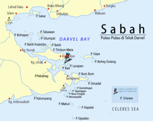
Pulau Silawa is an island belonging to the Malaysian state Sabah in Darvel Bay, which is open to the Celebes Sea . The island is about 11 kilometers northwest of Semporna . The largely flat island stretches 1.3 kilometers to the northeast and is up to 800 meters wide. In the south, Pulau Silawa borders directly on Pulau Bait ; the two islands are separated by a sandy, swampy strip at low tide. The island is separated from Pulau Larapan in the northeast by a navigable strait a few hundred meters narrow . The only small settlement Kampung Silawa is on the east coast .
Individual evidence
- ↑ Sailing Directions (Enroute) - Borneo, Jawa, Sulawesi and Nusa Tenggara (PDF; 5.8 MB), United States Navy Publication 163, sector 10, page 286, 2002; Accessed August 28, 2012
- ^ Topographic map 1: 90,000: Negeri Sabah Bahagian Tawau Daerah Semporna ; Eds. Jabatan Ukur & Permetaan Malaysia, 1st edition, 2010

