Pulau Tigabu
| Pulau Tigabu | ||
|---|---|---|
| Waters | Sulu Lake | |
| Geographical location | 6 ° 53 '19 " N , 117 ° 28' 29" E | |
|
|
||
| length | 1.7 km | |
| width | 1 km | |
| surface | 1.4 km² | |
| Highest elevation | 43 m | |
| Residents | about 700 500 inhabitants / km² |
|
| main place | Kg.Pulau Tibagu | |
| Location of Pulau Tigabu in the Sulu Sea | ||
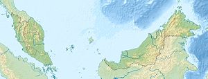
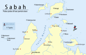
Tigabu Island is the Malaysian state of Sabah owned island in the Sulu Sea off the northern tip of Borneo . The island is 14 kilometers north of Pulau Jambongan , about 22 kilometers southeast of Pulau Malawali and 23 kilometers northeast of the mainland belonging to the Pitas district . Administratively, however, it belongs to the Kudat district . The island rises steadily from north to south and reaches a height of up to 43 meters. It is 1.7 kilometers long and one kilometer wide. At the highest point there is a 12 meter high lattice mast.
About 700 people live in 105 houses on the island. Most of them are Ubian, a subgroup of the Bajau , who earn their living fishing or raising sea cucumbers. The island has a small school (SK Pulau Tigabu, Banggi) and a police station.
Individual evidence
- ↑ Sailing Directions (Enroute) - Borneo, Jawa, Sulawesi and Nusa Tenggara (PDF; 5.8 MB), United States Navy Publication 163, sector 10, page 300, 2002; Accessed October 5, 2012
- ↑ Pulau Tigabu ( page no longer available , search in web archives ) Info: The link was automatically marked as defective. Please check the link according to the instructions and then remove this notice. , Blog page with pictures; Accessed October 5, 2012
Remarks
- ↑ The values were approximately determined by evaluating the satellite image from google maps.

