Pulau Malawali
| Pulau Malawali | ||
|---|---|---|
| Waters | Sulu Lake | |
| Geographical location | 7 ° 3 ′ 0 ″ N , 117 ° 18 ′ 0 ″ E | |
|
|
||
| length | 8.3 km | |
| width | 6 km | |
| surface | 39 km² | |
| Highest elevation | 138 m | |
| main place | Paramuan | |
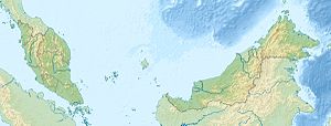
| Location of Pulau Malawali in the Sulu Sea | ||
Pulau Malawali is an island belonging to the Malaysian state Sabah in the Sulu Sea off the northern tip of Borneo . The island is located at the end of the Banggi South Straits , about 12 kilometers southeast of Pulau Banggi and 12 kilometers northeast of the mainland belonging to the Pitas district . Administratively, however, it belongs to the Kudat district . The hilly island rises up to 138 meters from the sea. It is 8.3 kilometers long and 6 kilometers wide.
Individual evidence
- ↑ Sailing Directions (Enroute) - Borneo, Jawa, Sulawesi and NUsa Tenggara (PDF; 5.8 MB), United States Navy Publication 163, sector 10, page 300, 2002; Accessed September 18, 2012
Remarks
- ↑ The values were approximately determined by evaluating the satellite image from google maps.

