Pulau Balambangan
| Pulau Balambangan | ||
|---|---|---|
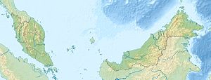
| Location of P. Balambangan off the north coast of Sabah | ||
| Waters | South China Sea | |
| Geographical location | 7 ° 16 ' N , 116 ° 56' E | |
|
|
||
| length | 24 km | |
| width | 7 km | |
| surface | 79 km² | |
| Highest elevation | Balambangan 119 m |
|
| Residents | some 100 (estimate) 1.3 inhabitants / km² |
|
| main place | Kg.Batu Sirih | |
Balambangan island , including Pulau Balembangan is the Malaysian state of Sabah owned island in the South China Sea off the northern tip of Borneo . The island is about 40 kilometers north of Kudat . The island extends 24 kilometers to the northeast and is up to 7 kilometers wide. A wooded hill 119 m high rises to the southwest. The island is separated from Pulau Banggi in the west by a four-kilometer-wide strait . The channel between the two islands is called West Banggi Strait or West Banggi Channel .
history
In August 1997, archaeological excavations provided evidence that the island was already inhabited in prehistoric times.
The British East India Company founded a trading post on Pulau Balambangan on January 23, 1763 after negotiations between Alexander Dalrymple and the Sultan of Sulu. However, it was not until 1773 that the company decided to use their acquisition economically and sent Captain John Herbert with the task of building a British colony on Balambangan. Herbert built a complete trading post with houses, offices, warehouses and a ship mooring. However, his difficult personality soon led to a falling out with the merchants of Sulu, who then allied themselves with the pirates of Marudu Bay. In 1775 the settlement was attacked by pirates and completely destroyed. According to legend, Captain Herbert had to leave a large amount of gold behind on the island when he escaped, which is why Pulau Balambangan is still called the "Treasure Island of Sabah" today.
Demographics
The villages on Pulau Balambangan are concentrated in the southwest of the island:
|
|
|
use
The island's inhabitants are mainly engaged in fishing. There are also some smaller areas where shifting cultivation is carried out and mainly vegetables are planted. A private company, Chung Pao Ocean Sdn. Bhd., Operates an aquaculture for sea cucumbers .
As early as 1930, the forest was recognized as worthy of protection and a first forest reserve was set up. In 1984 approximately 371 hectares of the island were declared a Protection Forest Reserve (FR).
Although the island has great potential for ecotourism in addition to its forest reserves and several archaeologically interesting sites , the Sabah government plans to make the island a center of the cement industry because of its limestone reserves . The plans would also affect the existence of more than 20 limestone caves, only four of which have been explored.
Web links
Individual evidence
- ↑ Sailing Directions (Enroute) - Borneo, Jawa, Sulawesi and NUsa Tenggara (PDF; 5.8 MB), United States Navy Publication 163, sector 10, page 302, 2002; Accessed August 28, 2012
- ^ Daily Express: Clinker or eco-tourism? , November 24, 2007 quoted in: [1]
- ^ FG Whelan: A History of Sabah , MacMillan & Co, Kuala Lumpur, 1970, 81
- ↑ Topographic map 1: 130,000: Negeri Sabah Bahagian Kudat Daerah Kudat ; Eds. Jabatan Ukur & Permetaan Malaysia, 1st edition, 2010
- ↑ http://www.sabah.gov.my/htan_caims/Level%202%20frame%20pgs/Class%201%20Frames/balembangan_fr.htm
- ↑ New Sabah Times: Caves of Balambangan Island , March 23, 2009 quoted in: [2]
- ^ Blog about cave of Balambangan Island ; Accessed September 2, 2012
Remarks
- ↑ The values were approximately determined by evaluating the satellite image from google maps.

