Pulau Batik Kulambu
| Pulau Batik Kulambu | ||
|---|---|---|
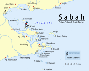
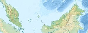
| Location of Pulau Bati Kulambu in Darvel Bay | ||
| Waters | Celebes Sea | |
| Geographical location | 4 ° 42 '0 " N , 118 ° 24' 0" E | |
|
|
||
| length | 4.9 km | |
| width | 2 km | |
| surface | 5 km² | |
| Highest elevation | 249 m | |
| Residents | uninhabited | |
Pulau Batik Kulambu is an island belonging to Malaysia in Darvel Bay, which is open to the Celebes Sea . The densely forested island is about 8 kilometers east of Kunak . The irregularly shaped island extends about 4.9 kilometers in an east-west direction and about 2 kilometers in a north-south direction. The island rises from the coast on all sides and reaches a height of up to 249 m. The island is separated from the island of Pulau Timbun Mata in the southeast by a narrow strait . Two bays on the south side extend 500 and 1100 meters into the island.
Individual evidence
- ↑ Sailing Directions (Enroute) - Borneo, Jawa, Sulawesi and NUsa Tenggara (PDF; 5.8 MB), United States Navy Publication 163, sector 10, page 287, 2002; Accessed August 24, 2012
Remarks
- ↑ The values were approximately determined by evaluating the satellite image from google maps.

