Pulau Mata Pahi
| Pulau Mata Pahi | ||
|---|---|---|
| Location of Pulau Mata Pahi in Darvel bay | ||
| Waters | Celebes Sea | |
| Geographical location | 4 ° 35 '3 " N , 118 ° 31' 7" E | |
|
|
||
| length | 900 m | |
| width | 200 m | |
| surface | 4.1 ha | |
| Highest elevation | 8 m | |
| Residents | uninhabited | |
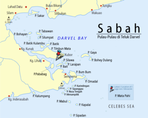
Mata Pahi ( Mal. Pulau Mata Pahi ) is an island belonging to Malaysia in Darvel Bay, which is open to the Celebes Sea . The island is about 15 kilometers northwest of Semporna .
Mata Pahi is a small island within Darvel Bay. It rises only a few meters above sea level and is mostly dense with mangrove trees. Its maximum length is approx. 900 m, the greatest width approx. 200 m. Pulau Mata Pahi is part of a larger sandbar that lies between Pulau Timbun Mata and the mainland.
The island is home to around 30,000 - 50,000 fruit bats .
Individual evidence
- ↑ Sailing Directions (Enroute) - Borneo, Jawa, Sulawesi and NUsa Tenggara (PDF; 5.8 MB), United States Navy Publication 163, Sector 10, 2002; Accessed August 24, 2012
- ↑ New Sabah Times, January 22, 2010 ( page no longer available , search in web archives ) Info: The link was automatically marked as defective. Please check the link according to the instructions and then remove this notice. ; Accessed March 12, 2012

