Pulau Danawan
| Pulau Danawan | ||
|---|---|---|
| Location of Pulau Danawan in the Celebes Sea | ||
| Waters | Celebes Sea | |
| Geographical location | 4 ° 18 '22 " N , 118 ° 51' 28" E | |
|
|
||
| length | 1.2 km | |
| width | 1 km | |
| surface | 44 ha | |
| Highest elevation | 17 m | |
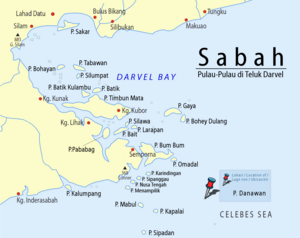
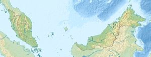
Danawan ( Mal. Pulau Danawan ) is an island belonging to Malaysia in the Celebes Sea . It is located about 35 kilometers southeast of Semporna and 100 kilometers east of Tawau off the east coast of Borneo .
description
The approximately 0.44 square kilometer island has the shape of a dented diamond, extends in the north-south extension over a length of 1.2 kilometers and is up to one kilometer wide in the east-west extension. The wooded, mostly flat island rises a few meters from the sea and reaches a height of 17 meters in the north and east. On the west side of the island there is a Bajau settlement .
Pulau Danawan belongs together with the islands of Pulau Kapalai , Pulau Mabul , Pulau Ligitan , Pulau Si Amil and Pulau Sipadan to the so-called "Ligitan Group".
Others
Pulau Danawan is often confused with the island of Pulau Dinawan on the west coast of Sabah .
Individual evidence
- ↑ a b Sailing Directions (Enroute) - Borneo, Jawa, Sulawesi and NUsa Tenggara (PDF; 5.8 MB), United States Navy Publication 163, sector 10, page 282, 2002; Accessed August 24, 2012
- ↑ Ligitan Coral Shelf - Diving Guide ( Memento of the original from November 29, 2014 in the Internet Archive ) Info: The archive link was automatically inserted and not yet checked. Please check the original and archive link according to the instructions and then remove this notice. (PDF; 1.5 MB); Accessed July 12, 2012
Remarks
- ↑ The values were approximately determined by evaluating the satellite image from google maps.

