Pulau Kapalai
| Pulau Kapalai | ||
|---|---|---|
| Location of Pulau Kapalai in the Celebes Sea | ||
| Waters | Celebes Sea | |
| Archipelago | Litigan group | |
| Geographical location | 4 ° 13 ′ 0 ″ N , 118 ° 41 ′ 0 ″ E | |
|
|
||
| length | 1.3 km | |
| width | 360 m | |
| surface | 30 ha | |
| Highest elevation | 1 m | |
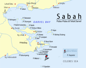
Pulau Kapalai is an island belonging to Malaysia in the Celebes Sea . The island belongs to the well-known diving area off Semporna and is about 15 kilometers from the island of Pulau Sipadan .
description
Pulau Kapalai is a narrow island covered in bushes. Originally standing up to twelve meters above sea level, the island has been severely eroded by erosion in the last 200 years and now only rises above sea level as a narrow strip of sand. On the northeast side there is a reef that extends towards the island of Mabul.
Pulau Kapalai belongs together with the islands of Pulau Danawan , Pulau Mabul , Pulau Ligitan , Pulau Si Amil and Pulau Sipadan to the so-called "Ligitan Group".
Web links
Individual evidence
- ↑ a b Sailing Directions (Enroute) - Borneo, Jawa, Sulawesi and NUsa Tenggara (PDF; 5.8 MB), United States Navy Publication 163, sector 10, page 282, 2002; Accessed August 24, 2012
- ↑ Ligitan Coral Shelf - Diving Guide ( Memento of the original from November 29, 2014 in the Internet Archive ) Info: The archive link was automatically inserted and not yet checked. Please check the original and archive link according to the instructions and then remove this notice. (PDF; 1.5 MB); Accessed July 12, 2012

