Pulau Mabul
| Pulau Mabul | ||
|---|---|---|
| Location of Pulau Mabul | ||
| Waters | Celebes Sea | |
| Geographical location | 4 ° 14 '44 " N , 118 ° 37' 52" E | |
|
|
||
| length | 800 m | |
| width | 500 m | |
| surface | 25 ha | |
| Highest elevation | 8 m | |
| Residents | some 100 400 inhabitants / km² |
|
| main place | Kampung Mabul | |
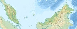
Mabul ( Mal. Pulau Mabul ) is an island belonging to Malaysia in the Celebes Sea . It is located about 30 kilometers south of Semporna and 80 kilometers east of Tawau off the east coast of Borneo .
description
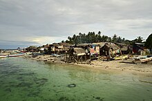
The approximately 0.25 square kilometer island has a length of 0.8 kilometers and a width of 0.5 kilometers. The island, which is only sparsely forested due to its tourist use, rises up to 8 meters from the sea. In the bank area there are settlements of the Bajau .
Pulau Mabul belongs together with the islands of Pulau Kapalai , Pulau Danawan , Pulau Ligitan , Pulau Si Amil and Pulau Sipadan to the so-called "Ligitan Group".
population
There are 2 villages on the island - Kampung Mabul and Kampung Musu. A large part of the inhabitants belong to the ethnic groups of the Bajau Laut and Suluk Muslim and come from relatively nearby island groups in the southern Philippines.
Public facilities on the island include a mosque, a community center and a primary school (Sekolah Kebangsaan Pulau Mabul). In 2009, 148 boys and girls were taught at the school. The most important means of transport is the boat.
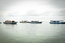
So-called sea nomads also live around the island . Depending on the season and the current, they lie with their houseboats just off the coast in the east or west of the island. The Pala'u group lives exclusively on boats where they are born and die. They generally earn their living by begging and selling small fish they have caught themselves to local diving centers .
The main source of income for the villages are sea products such as fish and small handcrafted souvenirs for tourists. The traditional fishing methods are called "Payau" and "Sangkaliya". Most fishermen on Mabul fish near the Philippine-Malaysian border, where it is mostly remote and quiet. The average fishing trip lasts 3-5 days and the fish are sold in Semporna .
In the 1970s, Mabul was owned by a Menampilik man who used the island to plant coconuts. In 1992 the Sipadan Mabul Resort (SMART) bought part of the land and made it usable for tourism.
Underwater world and diving
Pulau Mabul lies on the edge of a continental plate ; the seabed is 25 to 30 meters deep here. The underwater world around the island is home to a variety of cephalopods such as the splendid sepias , blue- ringed octopus , mimic octopus or the bobtail squid . In addition, different types of gobies live on Mabul Reef, such as the barbed fin goby, the black sail-fin goby and the metallic shrimp goby. Are common frog fish as well as the families of the scorpion and stone fish .
There are several diving resorts on Mabul as well as the possibility to spend the night on a converted oil rig about 500 meters from the beach . Some families also take in tourists as guests ("homestays") . A day trip to the nearby island of Pulau Sipadan can be organized from Pulau Mabul .
Mabul is a well-known place for macro underwater photography .
Web links
- Homepage of the island
Individual evidence
- ↑ a b Sailing Directions (Enroute) - Borneo, Jawa, Sulawesi and NUsa Tenggara (PDF; 5.8 MB), United States Navy Publication 163, sector 10, page 282, 2002; Accessed August 24, 2012
- ↑ Ligitan Coral Shelf - Diving Guide ( Memento of the original from November 29, 2014 in the Internet Archive ) Info: The archive link was automatically inserted and not yet checked. Please check the original and archive link according to the instructions and then remove this notice. (PDF; 1.5 MB); Accessed July 12, 2012
- ^ Underwater photography: Diving Sipadan, Mabul and Kapalai
- ↑ Diving in Mabul on mabul.com , accessed January 19, 2018.
Remarks
- ↑ The values were approximately determined by evaluating the satellite image from google maps.


