
Ra's al-Khaimah (emirate)
|
رأس الخيمة Ras al-Khaimah
|
|||
|---|---|---|---|
  |
|||
| Symbols | |||
|
|||
| Basic data | |||
| Country | United Arab Emirates | ||
| Capital | Ras al-Khaimah | ||
| surface | 1684 km² | ||
| Residents | 345,000 (2015) | ||
| density | 205 inhabitants per km² | ||
| ISO 3166-2 | AE-RK | ||
| Website | www.rak.ae | ||
| politics | |||
| emir | Saʿud ibn Saqr al-Qasimi | ||
 |
|||


Coordinates: 25 ° 42 ' N , 55 ° 57' E

Ra's al-Khaimah ( Arabic إمارة رأس الخيمة, DMG Imārat Raʾs al-Ḫaima 'top of the tent', often abbreviated to RAK or RAK after the English transcription Ras Al Khaimah ) is one of seven emirates that make up the United Arab Emirates (UAE). It joined the UAE in 1972 as the seventh and last.

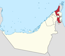
The emirate consists of two sub-territories: one in the far north of the country and one a few kilometers further south in the interior, roughly in the middle of the six eastern emirates. It has a size of 1,684 km² and makes up 2.17% of the area of the UAE. According to an estimate for 2015, around 345,000 people live there, the increase of around 5% per year corresponds to the general growth in the UAE.
Ra's al-Khaimah lives mainly from tourism , trade and agriculture. In the coastal plain there are extensive and fertile orange and date plantations that are irrigated by spring water from the nearby mountains.
There are archaeological excavations in Ra's al-Khaimah , some of which date back to the ancient city of Julfar .
history
The emirate was founded by the Qawasim tribe and named after the port of the same name, which is also the capital today. Since the end of the 18th century, the port served the pirate Qawasin as an important base. At the height of their power they ruled large parts of the Persian south coast. However, as piracy increasingly endangered the British shipping lanes in the Indian Ocean and in particular disrupted trade with Oman , it came to a military conflict with Great Britain. In 1819 Ra's al-Khaimah was attacked and occupied by a British naval force.

After this defeat, the Qawasim had to agree to a sea peace with Great Britain under their Sultan ibn Saqr (reign 1803-1866, with interruption) in 1820, which assured the British a protectorate over the southern Gulf Coast (from this treaty the term Trucial States is derived ). After the treaty was renewed (1853), the Emirate of Ra's al-Khaimah came increasingly under British rule. After the death of Sultan ibn Saqr, his territory split into the two independent emirates Sharjah and Ra's al-Khaimah in 1869 . From September 1900 to July 7, 1921, both emirates were reunited; the last governor was then appointed the new Emir of Ra's al-Khaimah.
Under Sheikh Saqr ibn Muhammad al-Qasimi , who had ruled since 1948 and was the longest-ruling head of state in the region, Ra's al-Khaimah joined the seventh and last emirate of the former Trucial States on February 10, 1972, on December 2, 1971 after gaining independence United Arab Emirates created by Great Britain . In 1999, Chalid ibn Saqr al-Qasimi , then Crown Prince and eldest son of Sheikh Saqr, took over the management of state affairs from his father, which he had given up for health reasons.
In 2003, Sheikh Saqr's fourth eldest son, Sheikh Saʿud ibn Saqr al-Qasimi , was appointed crown prince in place of Sheikh Chalid and has been in charge of the state since then. Sheikh Saud bin Saqr al Qasimi was officially confirmed as ruler after the death of his father on October 27, 2010.
geography
![]() Map with all coordinates: OSM | WikiMap
Map with all coordinates: OSM | WikiMap
The emirate is characterized by a more lush vegetation in relation to the other emirates , which is made possible by the more frequent rainfall in the Hajar Mountains , which occupy large parts of the hinterland, and thus a higher groundwater level. This allows a partly intensive and extensive agriculture, especially along the numerous dry rivers and in the coastal dry savannah , which is characteristic of the north, while in the south there is a sandy desert with partly large dunes, which are offshoots of the Rub al-Chali .
Protected lagoons along the coast allow a wide-ranging and diverse flora and fauna that have been able to establish themselves away from the strong ocean currents. These lagoons often formed the basis for the establishment of a permanent settlement, as they provided a safe haven for trade and fishing. For the local bird world as well as the marine fauna they represent important retreat and recreation areas. The vegetation of these lagoons is characterized by large-scale mangrove forests, which are probably the most important ecosystem, and in and around the preferably shallow waters there are salt marshes , mud flats and low ones Vegetation. At the same time, these lagoons are also a very endangered ecosystem, as they are being increasingly piled up by the growing cities and settlements in order to gain new building land. See for example Mina Al Arab .
List of wadis
The table below shows the largest wadis in Ra's al-Khaimah.
| Surname | Coordinates | description |
|---|---|---|
| Wadi Sham | 26 ° 1 ′ 53 " N , 56 ° 7 ′ 24" E | Suitable for bird watching, agricultural use in the estuary |
| Wadi Galilah | 25 ° 58 '12 " N , 56 ° 5' 47" E | Acacia-dominated vegetation, agriculture near the coast |
| Wadi Litibah | 25 ° 59 ′ 6 ″ N , 56 ° 8 ′ 7 ″ E | Starting point for the Stairway to Heaven hiking trail |
| Wadi Haqil | 25 ° 48 '55 " N , 56 ° 3' 1" E | extensive agriculturally used areas, estuary built in the meantime |
| Wadi Bih | 25 ° 47 '5 " N , 56 ° 3' 52" E | consisting of several tributaries and tributaries z. B .: Wadi Hafarah, Wadi Shisa, Wadi Shah, Wadi Quada'a (Quadara) , flows into the Ra's al-Chaima Creek |
| Wadi Naqab | 25 ° 41 ′ 43 " N , 56 ° 2 ′ 49" E | seeps into the desert, extensive agricultural use, is used to irrigate the Saqr Park |
| Wadi Baqal | 25 ° 41 ′ 11 " N , 56 ° 5 ′ 14" E | not used, far in the hinterland near the border with Fujairah |
List of lagoons
There are several lagoons along Ra's al-Khaimas coast . These are called Chaur /خور / ḫaur (English translation Khor or Khaur , description Creek ). Here are the four largest lagoons:
| Surname | Coordinates | description | image |
|---|---|---|---|
| Chaur Hulaila | 25 ° 54 ′ 0 ″ N , 56 ° 2 ′ 32 ″ E | Borders to the north with Chaur Chuwair , to the south with ar-Rams . Contains the RAK Free Trade Zone as well as other industrially used areas. Chaur Khuwair can be overlooked from the nearby Dhaya Fort . The name comes from the nearby settlement of al-Hulaila . The bay is separated from the Persian Gulf by the island of Hulaila . This island is one of the most important archaeological sites in the UAE. The oldest finds come from the time of the Sassanid Empire . | |
| ar rams | 25 ° 51 ′ 52 " N , 56 ° 0 ′ 34" E | ar-Rams comprises the coastal region from ar-Rams to Ra's-al-Khaimah city as well as the island of Rams. The United Nations lists the lagoon as a reserve. | |
| Chaur Ra's al-Khaimah | 25 ° 46 '48 " N , 55 ° 57' 13" E | Lagoon in the center of Ras al-Khaimas with lush vegetation and the largest mangrove forest in the emirate. Along the lagoon is the Corniche and the shopping center Al Manar Mall and Tower Links Golf Club , which also partly on the island of al-Qurm located. |

|
| Chaur al-Jazeera | 25 ° 43 '20 " N , 55 ° 50' 59" E | Also known as the Chaur Qurm . Lagoon surrounded by sand dunes and natural vegetation. Located between the construction project The Cove on the southern outskirts of Ra's al-Khaimah and the Al Jazeera Port near the Jazirat al-Hamra settlement . The Mina Al Arab construction project is currently being implemented in the southern half of the lagoon . |
climate
| Ras al-Khaimah | ||||||||||||||||||||||||||||||||||||||||||||||||
|---|---|---|---|---|---|---|---|---|---|---|---|---|---|---|---|---|---|---|---|---|---|---|---|---|---|---|---|---|---|---|---|---|---|---|---|---|---|---|---|---|---|---|---|---|---|---|---|---|
| Climate diagram | ||||||||||||||||||||||||||||||||||||||||||||||||
| ||||||||||||||||||||||||||||||||||||||||||||||||
|
Average monthly temperatures and rainfall for Ras al-Khaimah
Source: WMO
|
|||||||||||||||||||||||||||||||||||||||||||||||||||||||||||||||||||||||||||||||||||||||||||||||||||||||||
Administrative division
The emirate is divided into five administrative areas : The southern inland part of the area, an exclave , is listed as The Third Area: The Southern area :
- The First Area: Ras Al Khaimah City, with the old and modern districts of Ras Al Khaimah. It extends to Al Jazirah Al Hamra on the coast 14 km southwest of the city center.
- The Second Area: The northern area, with Shaam, Ghalilah, Al Jeer, Al Ramas (= Al Rams?) And Al Shamal.
- The Third Area: The southern area (exclave), with Massafi, Kedra, Al Huwaylat, Al Ghail, Uthun, Asema, Dafta and Rafak.
- The Fourth Area: The area of Al Nakheel was a popular summer stay for residents of Ras Al Khaimah and other emirates.
- The Fifth Area: This area extends from Al Dhait South to Al Khatt; it is a rural, agricultural area that includes Al Kharran 13 km from Ras Al Khaimah, as well as Al Digdaga (23 km), Al Humranya (28 km) and Khatt (33 km).
The administrative areas are further subdivided into 82 districts.
The principal places originally claimed from 1948.
traffic
The emirate is connected to international air traffic via the Ra's al-Khaimah airport . The airline RAK Airways , which was based there until it ceased operations on December 31, 2013 , maintained flight connections to Europe, the Middle East and the Indian subcontinent. On February 2, 2014, the Department of Civil Aviation of the Emirates Ra's al-Khaimah appointed the semi-state airline Air Arabia, founded in the Emirate of Sharjah , as the new national airline .
Ra's al-Khaimah is connected to the other emirates by road via Sheikh Mohammed bin Zayed Road . The travel time to Dubai is around 1–1.5 hours.
Construction projects
Similar to the other Emirates of the UAE , some construction projects are currently being realized or are in the planning phase, mainly near the coast, in Ra's al-Khaimah. The state developer of Ra's al-Khaima is called RAK Properties , other important companies in the development of new building projects are for example Rakeen or Al Hamra Real Estate . The location right by the sea is characteristic of almost all projects, where, similar to Dubai , attempts are also being made here to extend the natural coastline through lagoons, canals and embankments in order to achieve higher prices for properties on the beach, despite the sometimes questionable quality of the Objects.
Mina Al Arab
Mina Al Arab (German: Port of Arabia) is a mixed area that has been under construction since 2007, southwest of Ra's al-Khaimah city in the Chaur al-Jazira lagoon . The developer RAK Properties plans to build several resorts and public facilities to boost tourism in the emirate. The complex also includes a harbor, a souq and several residential areas. With an area of 2.8 km², the project is one of the smaller projects in the emirate.
Al Marjan Island
Al Marjan Island (German: Coral Island) is one of the most advanced construction projects in Ra's al-Khaimah. It is located about 27 km from Ra's al-Khaimah city in the direction of the border with Umm al-Qaiwain and comprises a complex of 4 artificially raised islands and a peninsula. At 2.7 km² it is slightly larger than Mina Al Arab, but significantly smaller than other construction projects that are currently being realized in the emirate. The development began in part after the earthworks were completed in January 2008. The property developer Rakeen, for example, completed the pile foundation on all buildings with the construction work on the company's own mixed project Bab Al Bahr . The mixed use is characteristic of the development of the island, in general apartments, villas, resorts, hotels, shopping centers and some office buildings are to be built. Here, too, the declared aim is to stimulate tourism.
Al Hamra Village
Al Hamra Village is the most advanced construction project in Ra's al-Khaimah. The location is near the Al Marjan archipelago on a former lagoon area. The total area is 5 km², making the project the second largest in the emirate after Al Dana Island . The complex, consisting of numerous villas, two hotels, a shopping center, golf course and marina, is being realized by the state-owned company Al Hamra Real Estate . The project is divided into five phases, the first three of which are under construction or completed. Phases four and five will presumably be sold with a delay due to the current economic situation and their volume will be downgraded. The Al Hamra Palace Hotel , which is currently under construction , will be the third tallest building in the emirate and also have the largest capacity. Together with the already existing Al Hamra Fort Hotel & Beach Resort , the aim is to accommodate the expected excess number of tourists. These should get the feeling of being housed in an old Arabic settlement .
Industry / economy
RAK Ceramics is a major producer of ceramic tiles and sanitary ware with annual sales of over $ 1 billion and offices in around a dozen countries, including a. in Germany, Great Britain, Italy, Belgium, Australia, China, India and Saudi Arabia.
In February 2006, the administration of Ra's al- Khaimah announced an investment of 30 million US dollars for the construction of the spaceport Ras Al-Khaimah Spaceport in cooperation with the US American Space Adventures Ltd. The considerable container port and Ra's al-Chaima's airport (IATA airport code RKT), which is currently being expanded, are also important transshipment points for Iran to circumvent UN sanctions.
See also
- al-Qasimi , List of the rulers of Ras al-Khaimah
Web links
- Ras al-Khaimah e-Government
- Ras al-Khaimah Tourism Office (English)
- Districts of the city of Ras al-Khaimah (map)
Individual evidence
- ^ Historical Summary of Events in the Persian Gulf Shaikhdoms and the Sultanate of Muscat and Oman, 1928-1953 , p. 143
- ↑ UAE Sites ( Memento of the original from December 14, 2007 in the Internet Archive ) Info: The archive link was inserted automatically and has not yet been checked. Please check the original and archive link according to the instructions and then remove this notice.
- ↑ UAE Interact: Hulaylah Island ( Memento of the original from November 22, 2008 in the Internet Archive ) Info: The archive link was inserted automatically and has not yet been checked. Please check the original and archive link according to the instructions and then remove this notice.
- ↑ UNEP: Rams Lagoon ( page no longer available , search in web archives ) Info: The link was automatically marked as defective. Please check the link according to the instructions and then remove this notice.
- ^ Administrative Division
- ↑ Statistical Yearbook 2013 , p. 431
- ↑ [1]
- ↑ RAK Ceramics (official website)
- ↑ Gulf News: UAE to tap space tourism (February 17, 2006)
- ↑ Tages Anzeiger: [2] (October 7, 2011)
Abu Dhabi | Ajman | Dubai | Fujairah | Ras al-Khaimah | Sharjah | Umm al-Qaiwain