
Rank things
| coat of arms | Germany map | |
|---|---|---|

|
Coordinates: 48 ° 23 ' N , 8 ° 53' E |
|
| Basic data | ||
| State : | Baden-Württemberg | |
| Administrative region : | Tübingen | |
| County : | Zollernalb district | |
| Height : | 421 m above sea level NHN | |
| Area : | 21.67 km 2 | |
| Residents: | 5255 (Dec. 31, 2018) | |
| Population density : | 243 inhabitants per km 2 | |
| Postal code : | 72414 | |
| Area code : | 07471 | |
| License plate : | BL, HCH | |
| Community key : | 08 4 17 051 | |
| LOCODE : | DE DXG | |
| Community structure: | 3 districts | |
| Address of the municipal administration: |
Schulstrasse 8 72414 Rangendingen |
|
| Website : | ||
| Mayor : | Johann Widmaier | |
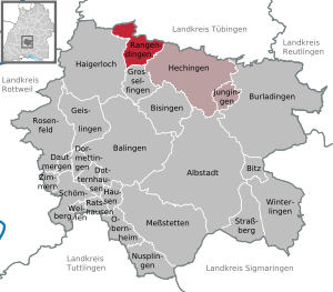
| Location of the municipality of Rangendingen in the Zollernalb district | ||
  |
||

Rangendingen is a municipality in the Zollernalb district in Baden-Württemberg .
geography
Geographical location
Rangendingen is located between Hechingen and Haigerloch in the Starzel valley . Parts of the nature reserves Espenloch-Hintere Halde and Kapfhalde are located in the districts of Rangendingen and Hirrlingen .
Community structure
The community consists of the districts Rangendingen (4083 inhabitants on December 31, 2012), Bietenhausen (501 inhabitants) and Höfendorf (536 inhabitants). Bietenhausen and Rangendingen each only consist of the villages of the same name. The village Höfendorf and the homestead Vogelherdhof belong to the district Höfendorf.

history
|
Rangendingen was mentioned in a document as early as 795. The document is a deed of donation, drawn up by the priest Audacar for a certain Heriker, who gave everything that he owned here to the St. Peter's Church in "Rangodinga" for the salvation of his soul. This document with the first mention of rank things has been preserved in the monastery of St. Gallen . Small remains of Hohenrangendingen Castle from the 13th century can still be found on the "Hochburg" hill . |
 |
The Höfendorf district is first mentioned in 1095 in a deed of donation from the Alpirsbach monastery. |
 |
The district of Bietenhausen is only proven with certainty in 1275. |
Bietenhausen and Höfendorf were incorporated into Rangendingen on April 1, 1972.
politics
Spatial planning
Rangendingen belongs together with Hechingen , Burladingen , Bisingen , Haigerloch , Grosselfingen and Jungingen as part of the regional planning and planning region Neckar-Alb to the central area Hechingen and together with Jungingen is a member of the administrative community Hechingen .
Municipal council
The local council in Rangendingen has 18 members. The municipal council consists of the elected voluntary councilors and the mayor as chairman. The mayor is entitled to vote in the municipal council. The local elections on May 29, 2019 led to the following preliminary final result. The turnout was 59.4%.
| Political party | be right | Seats |
| Rangendinger citizens | 54.03% | 10 |
| Free voters Rangendingen | 45.97% | 8th |
mayor
In February 2016, Johann Widmaier was re-elected for a third term.
Economy and Infrastructure
Industry and commerce
The Trigema company has a branch in Rangendingen with a factory outlet and a petrol station.
traffic
The Public transport is by the Verkehrsverbund Neckar-Alb-Donau guaranteed (NALDO). The community is located on the honeycomb border 329/332.
Power supply
The power grid in the community is operated by EnBW Regional AG.
Gas supply
The natural gas network is operated by FairEnergie GmbH , a subsidiary of Stadtwerke Reutlingen GmbH and EnBW Kommunale Beteiligungen GmbH.
Water supply
The drinking water is obtained from the Starzel-Eyach water supply group based in Haigerloch . The drinking water is supplied from the Hirrlinger Mühlen waterworks in Bietenhausen.
Sons and daughters of the church
- Jakob Hermann (1872–1952), politician (center, CDU), member of the state parliament
Individual evidence
- ↑ State Statistical Office Baden-Württemberg - Population by nationality and gender on December 31, 2018 (CSV file) ( help on this ).
- ↑ General municipality data
- ^ The state of Baden-Württemberg. Official description by district and municipality. Volume VII: Tübingen administrative region. Kohlhammer, Stuttgart 1978, ISBN 3-17-004807-4 . Pp. 229-231
- ^ Federal Statistical Office (ed.): Historical municipality directory for the Federal Republic of Germany. Name, border and key number changes in municipalities, counties and administrative districts from May 27, 1970 to December 31, 1982 . W. Kohlhammer, Stuttgart / Mainz 1983, ISBN 3-17-003263-1 , p. 528 .
- ↑ http://www.swp.de/hechingen/lokales/hechingen/98-prozent-fuer-widmaier-11884526.html
- ↑ BDEW (Ed.): Map of the electricity network operator 2012. Frankfurt 2012.
- ↑ BDEW (Ed.): Map of the gas network operators 2012. Frankfurt 2012.
Web links

Albstadt | Balingen | Bisingen | Bitz | Burladingen | Dautmergen | Dormettingen | Dotternhausen | Geislingen | Grosselfingen | Haigerloch | Hausen am Tann | Hechingen | Jungingen | Meßstetten | Nusplingen | Obernheim | Rangendingen | Ratshausen | Rosenfeld | Schömberg | Straßberg | While under the gutters | Winterlingen | Rooms under the castle