
While under the gutters
| coat of arms | Germany map | |
|---|---|---|

|
Coordinates: 48 ° 11 ' N , 8 ° 46' E |
|
| Basic data | ||
| State : | Baden-Württemberg | |
| Administrative region : | Tübingen | |
| County : | Zollernalb district | |
| Height : | 707 m above sea level NHN | |
| Area : | 3.08 km 2 | |
| Residents: | 613 (December 31, 2018) | |
| Population density : | 199 inhabitants per km 2 | |
| Postal code : | 72367 | |
| Area code : | 07427 | |
| License plate : | BL, HCH | |
| Community key : | 08 4 17 071 | |
| Address of the municipal administration: |
Angelstraße 1 72367 Weilen unter den Ginnen |
|
| Website : | ||
| Mayor : | Gerhard Reiner | |
| Location of the community of Weilen unter den Rinnen in the Zollernalb district | ||
  |
||

Weilen unter den Rinnen is a municipality in the Zollernalbkreis in Baden-Württemberg ( Germany ). Apart from the village of the same name, no other places belong to the municipality of Weilen unter den Rinnen.
geography
Geographical location
Weilen unter den Rinnen lies on the western Swabian Alb . The community belongs to the spatial and recreational area of Upper Schischemtal .
Neighboring communities
The following cities and municipalities border the municipality of Weilen unter den Rinnen. They are named starting in the north in a clockwise direction and belong to the Zollernalb district or the Tuttlingen district ¹:
Schömberg , Ratshausen and Deilingen ¹.
Historical geography
In the municipality which are deserted villages laughter Armweiler and Hochstetten and Outbound Castle Heide Schlössle in the hallways Postal and Heidenschlößle . Lachen probably originated in the 8th century and was first mentioned in 785 as in loco Lahha . The place existed until the 13th century. The Ottilien Chapel, which was formerly called St. Maria, was part of Lachen. Armweiler was first mentioned as a field name Armweyler in 1685. The first mention of the name Hochstetten is unknown still exists the Flurname Hochstetts .
history

Weilen was first mentioned as a hamlet around 1113 and was at the time in the area of the Duchy of Swabia .
Until 1805 Weilen belonged to the Upper Austrian county of Oberhohenberg. As a result of the mediatization , the place came to the Electorate of Württemberg. In the Kingdom of Württemberg Weilen was assigned to the Oberamt Spaichingen . In the course of the regional reform in 1938, Weilen came to the Balingen district and, after its dissolution in 1973, to the Zollernalb district.
On September 20, 1977, two American fighter planes from Spangdahlem crashed near the village. Three soldiers were able to save themselves with the ejection seat. The fourth, Captain John Mike Wertz, died on impact.
politics
Municipal council
The municipal council in Weilen unter den Rinnen has 8 members. It consists of the elected honorary councilors and the mayor as chairman. The mayor is entitled to vote in the municipal council. In 2014, the municipal council was still elected by majority vote. Majority voting takes place if no or only one nomination has been submitted.
In the local elections on May 26, 2019 , there were two lists. The turnout was 75.2%.
| Political party | be right | Seats |
| Free electoral association | 67.15% | 5 |
| List two | 32.85% | 3 |
mayor
In March 2015, Gerhard Reiner (CDU) was elected the new mayor in the second ballot with 52.53% of the vote, Stephan Reuss (non-party) received 46.67%. The predecessor was Richard Ege.
Culture and sights

Attractions
- Catholic Church of St. Nicholas with sculptures by the Master of Weilen from around 1530 on the altar

Saint Nicholas, Saint Ottilia
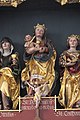
Saint Ottilia, Madonna and Child, Saint Catherine

Saint Catherine, John the Baptist


societies
- Narrenzunft Weilen ("Hummel")
- Musikverein Weilen
- Sports community while
Natural monuments
- Gorges of the Rinnen on the Albtrauf with the waterfall of the Mittelbach and the waterfall on the Heidenschlössle
traffic
The Public transport is by the Verkehrsverbund Neckar-Alb-Donau guaranteed (NALDO). The community is located in honeycomb 334.
Sons and daughters of the church
- August Blepp (1885–1949), church painter
Individual evidence
- ↑ State Statistical Office Baden-Württemberg - Population by nationality and gender on December 31, 2018 (CSV file) ( help on this ).
- ^ The state of Baden-Württemberg. Official description by district and municipality. Volume VII: Tübingen administrative region. Kohlhammer, Stuttgart 1978, ISBN 3-17-004807-4 . Pp. 248-249
- ^ Ludwig Karl Schmidt: History of the Counts of Zollern-Hohenberg and their county , Stuttgart 1862; P. III f.
- ↑ Local history with a description of the plane crash (accessed on April 19, 2018)
- ↑ Local election data 2019 of the State Statistical Office
Web links

Albstadt | Balingen | Bisingen | Bitz | Burladingen | Dautmergen | Dormettingen | Dotternhausen | Geislingen | Grosselfingen | Haigerloch | Hausen am Tann | Hechingen | Jungingen | Meßstetten | Nusplingen | Obernheim | Rangendingen | Ratshausen | Rosenfeld | Schömberg | Straßberg | While under the gutters | Winterlingen | Rooms under the castle