
Rantum
|
Rantum
Sylt municipality
Coordinates: 54 ° 50 ′ 49 ″ N , 8 ° 17 ′ 34 ″ E
|
||
|---|---|---|
| Height : | 3 m above sea level NHN | |
| Area : | 9.39 km² | |
| Residents : | 561 (Dec 31, 2007) | |
| Population density : | 60 inhabitants / km² | |
| Incorporation : | January 1, 2009 | |
| Postal code : | 25980 | |
| Area code : | 04651 | |
Location of Rantum in Schleswig-Holstein |
||

Rantum ( North Frisian : Raantem ) is a district of the municipality of Sylt on the island of Sylt , south of Westerland in the district of North Friesland .
Surname
The name of the place is often associated with the name of the sea goddess Ran ; Rantum as a place of Ran . More likely, however, is the derivation from the old spelling of the place name Raanteem as a place on the edge.
history

The small town of Rantum has an eventful history. It is located at what is now the narrowest point on the island, only about 550 meters wide. The place had to be rebuilt up to six times because it had been destroyed by storm surges and filled in with drifting sand. In 1801 the fourth church had to be demolished. The parish was abandoned. Only in 1964 did the village get its own church again.
According to information from the 18th century, an earth wall similar to the Tinnumburg was located near the place , the remains of the Rantum castle , which was buried by the dunes at that time and is now probably removed by the North Sea.
The earliest mention of the name Rantum can be found on an old nautical chart from 1142, which is kept in Copenhagen. The Rantum Church, the Westerseekirche, is marked as a navigation mark on the nautical chart. The Rantum Church was called St. Peter. Since only main churches were consecrated to Saint Peter at that time , it can be assumed that the place Rantum was an important place around 1100 AD. There is no evidence of this thesis. Probably the Rantum owned fertile marshland in the Middle Ages , as the island extended several kilometers to the west. But since the town of Rantum was twice so badly damaged by repeated storm surges that it had to be rebuilt elsewhere, including the church, there is only historical evidence from the 17th century. After the storm surges tore away the marshland and the shifting dunes became a threat, the place became impoverished. Until the 18th century the place was a stronghold for beach robbers . The inhabitants looted ships and made a living with the booty. While there had been 40 houses around 1700, the town, which had been moved to the east, consisted of only five houses in 1903. The third church, built in 1725, was buried by the sand in 1757. The successor building erected further east suffered the same fate in 1801. The parish was given up.
While Westerland had long been a tourist destination, a first rest home was only set up in Rantum after the First World War. From 1936 barracks were built for the Seefliegerhorst . A large mudflat area, the Rantum Basin , was surrounded by an outer dike and was intended to serve as a sea airport. After the Second World War, refugees moved into the barracks. In 1948 Hörnum was spun off as a separate municipality. Today the Rantum basin is a bird sanctuary. Over 182 species of birds could be counted here. They are looked after by a bird warden. In 1977, the port of Rantum was created from the former pier of the Seefliegerhorst as a tide-dependent sports boat harbor .
Today Rantum is considered an idyllic island village in the dunes . The Wadden Sea and the Rantum-Inge - a large salt marsh area - extend east of the town . To the west is the beach facing the open North Sea .
On January 1, 2009, Rantum joined the merger of the city of Westerland and the municipality of Sylt-Ost to form the new municipality of Sylt .
Attractions

The Eidum bird bunk , which was used to catch ducks , is worth seeing . It is named after the place Eidum , which sank in the floods in 1436.
The Rantum basin was created by the Wehrmacht as a landing pad for seaplanes. The construction work for the naval seaplane base in Rantum began in 1937. However, the basin was not long enough to offer the seaplanes used at the time an optimal starting point. Today the Rantum basin is a bird sanctuary and, like the bird bunk, is looked after by the Jordsand Association.
Since 1993, iodine-containing water has been pumped from the Sylt spring from several hundred meters deep and bottled. Exhibitions, readings, discussion forums and theater performances take place in the neighboring art space Sylt-Quelle . Since 2007 it has also been the venue for the “Meerkabarett”, an annual entertainment show with cabaret artists and comedians that takes place in the summer months .
At the Watts page to the east of the town is extending Schleswig-Holstein Wadden Sea National Park . A popular mudflat hike leads south from Rantum to Hörnum . The Wadden Sea Conservation Station has a branch in Rantum. From there, information events about coastal protection , the mudflats, the salt marshes and guided mudflat hikes are offered.
In Rantum there is a transmitter of the LORAN-C radio navigation system , which uses a 193 meter high, guyed and self-radiating steel framework mast as a transmitting antenna . Regular operation ended on December 31, 2005.
Tourism as the main source of income
In the dunes in the west there are several beach crossings with beach chair rentals and excursion restaurants with exotic names. This naming had its origin in the 1930s when a stretch of beach called Abyssinia was created. When tourism began to flourish in Rantum in the 1950s, the beach section Samoa was created , and later also Zanzibar.
Many families started renting rooms in the summer weeks of the 1950s. This thriving and profitable sideline has become one of the town's main sources of income over the decades. Many new buildings go to his account. What was decisive was that this was not done predominantly in hotels, guest houses and restaurants , as was the case in Westerland , for example . Many second homes and rental companies have now been added. As on the rest of the island, there are more beds for tourists than for permanent residents. The 1990s were important, when the season was extended beyond the few summer weeks. The thatched Söl'ring Hof stands directly on the dune threatened by storm surges . The hotel has now been awarded two Michelin Guide stars for its good cuisine . In June 2007 the so-called TUI village hotel with around 600 beds in 159 apartments was opened on an area formerly used by the military to the north of the town center .
Youth work
The youth camp site White Tent City Rantum is located in Rantum. The Schleswig-Flensburg District Sports Association offers youth camps there during the summer holidays.
The Arbeitsgemeinschaft Deutsches Schleswig operates a conference center for young people and a school camp in the “ADS Gerd-Lausen-Haus” training center .
In the south of the village is the Puan Klent youth recreation center , which is operated by the Puan Klent Youth Recreation Center in Hamburg .
Picture gallery

Port of Rantum

Strandweg, view towards Hörnumer Straße

St. Peter's Church
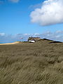
Nature reserve Baakdeel-Rantum / Sylt , view of the Sölring Hof
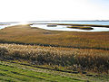
View over the nature reserve Rantumbecken

View of the dike that separates the Rantum basin (left) from the Wadden Sea

_Strandweg.jpg)
.jpg)


Web links
Individual evidence
- ↑ See article Rantumburg. In: Harry Kunz, Thomas Steensen: The new Syltlexikon. Wachholtz, Neumünster 2007, p. 307
- ↑ See article Rantum in the Syltlexikon . Pp. 305-307
- ↑ Article Rantum in the Syltlexikon . P. 306
- ^ ADS Rantum History ( Memento from December 17, 2011 in the Internet Archive )
- ↑ StBA: Area changes on 01/01/2009