
Rantum basin
|
Rantum basin Sylt
|
||
 Aerial view of the Rantum Basin |
||
| location | Sylt, North Friesland District, Schleswig-Holstein, Germany | |
| surface | 576 ha | |
| Identifier | NSG 60 | |
| WDPA ID | 4380 | |
| Geographical location | 54 ° 52 ' N , 8 ° 19' E | |
|
||
| Setup date | November 29, 1983 | |
| administration | Federal Agency for Nature Conservation | |
| Legal basis | State ordinance on the nature reserve "Rantumbecken" | |

The Rantum Basin is a nature reserve (a brackish lake) in the middle of the island of Sylt, south of the towns of Westerland and Tinnum . It is named after the place Rantum . This protected area is looked after by the Jordsand Association .
history
In the years 1936-37 was commissioned Wehrmacht by the Reichsarbeitsdienst southeast of Westerland with a five kilometer dike a 576 hectare large tidal flats of the Wadden Sea separated. It was intended to serve as an air base for sea pilots for the Air Force , as their seaplanes could not land there at any time due to the often rough North Sea and the tide-dependent water levels. Two pump stations in the dike were supposed to keep the water level at a level suitable for flight operations. But as soon as the basin was completed, it was classified as “no longer important to the war effort”, since the Wehrmacht had occupied the Danish mainland with the Weser Exercise company in April 1940 and was able to set up more suitable airfields there. In addition, the technical development had the often cumbersome seaplanes of the Dornier Wal or similar type. almost completely displaced from strategic warfare, so that the seaplane remained largely insignificant. After the end of the Second World War , the intention was to dry up the basin and establish a Koog with four farms.
Later the wastewater from Westerland was fed into the basin. From 1962 the basin was extensively renatured and a sea bird sanctuary was established there, which was declared a European reserve in 1968 . Different biotopes such as meadows , swamps , water and sand areas developed over time.
Surroundings
On the north side of the Rantum Basin lies the Nossekoog, which is mainly used as pastureland. There is also the largest tributary, the Waadens-Sill. On the northwest side there is a Remondis waste disposal center and the island's central sewage treatment plant. In the south-west there is a campsite and a tent camp of the Kreis-Sport-Verband. A large hotel complex has been located on the former barracks area directly on the southwest bank of the Rantum Basin since 2006.
- The rantum basin

Information board for the Rantum basin
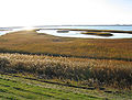
View over the Rantum basin to the island of Sylt

View of the dike that separates the Rantum basin (left) from the Wadden Sea

Stone island with cormorants in the Rantum basin

View of the tributary, the Waadens-Sill, north of the Rantum basin


.JPG)

swell
- State ordinance on the “Rantumbecken” nature reserve of November 29, 1983
- Site plan for the state ordinance
Individual evidence
- ↑ Peter Kuhlemann was responsible for the major part of the renovation planning .
Web links


Ahrenviöler Südermoor | Ahrenviölfelder Westermoor | Amrum dunes | Baakdeel-Rantum / Sylt | Beltringharder Koog | Bordelumer Heide and Langenhorner Heide with surroundings | Braderuper Heide / Sylt | Dithmarscher Eidvorland with Watt | Dune landscape on the Rote Kliff / Sylt | Eichkratt Schirlbusch | Alder break | Green island with Eiderwatt | Hamburger Hallig | Hörnum-Odde / Sylt | Kampener Vogelkoje on Sylt | Leak field | Löwenstedter Sandberge | Lütjenholm Heath Dunes | Morsum Cliff | Nielönn / Sylt | North Frisian Wadden Sea | North Sylt | Northern tip of Amrum on the island of Amrum | Oldenswort foreland | Rantum basin | Rantum dunes / Sylt | Rickelsbüller Koog | Schwansmoor and Kranichmoor | Schwarzberger Moor | Süderberge | Süderlügumer inland dunes | Wadden Sea north of the Hindenburg dam | Wester-Spätinge | Wild moor near Schwabstedt