
Scheidgraben (Rhine Low Canal)
|
Scheidgraben Fuchsgraben, Rossstapfengraben (section names ) |
||
 Aqueduct of the canal stream over the Scheidgraben near Stollhofen |
||
| Data | ||
| Water code | DE : 2357924 | |
| location |
Ortenau-Bühler foothills
|
|
| River system | Rhine | |
| Drain over | Rhine Low Canal → Rhine → North Sea | |
| Emergence | at Eichelsberg south of Sasbach 48 ° 37 '49 " N , 8 ° 5' 47" E |
|
| Source height | 162 m above sea level NHN | |
| muzzle | west of Stollhofen from the right into the Rhine Lower Canal Coordinates: 48 ° 45 ′ 56 ″ N , 8 ° 2 ′ 20 ″ E 48 ° 45 ′ 56 ″ N , 8 ° 2 ′ 20 ″ E |
|
| Mouth height | 121 m above sea level NHN | |
| Height difference | 41 m | |
| Bottom slope | 2 ‰ | |
| length | 20.1 km | |
| Catchment area | 32.6 km² | |
The Scheidgraben is a drainage canal in the north of the Ortenau district and in the south of the Rastatt district . It arises near the municipality of Sasbach and flows around 20 kilometers through the Upper Rhine Plain near Rheinmünster - Stollhofen from the right and east into the Rhine Low Canal .
geography
course
The Scheidgraben arises under the local name Fuchsgraben in the wet meadows of a valley gully in the foothills of the northern Black Forest , which lies in the area of the municipality of Sasbach between the Schänzel and Eichelsberg tubs . Heading north to north-westerly and shown in the topographical map as only occasionally bearing water, the Fuchsgraben flows for a good 700 meters through an area that is mainly used for fruit growing. In the following section, the Fuchsgraben separates the built-up areas of the city of Achern on the left bank and the municipality of Sasbach on the right bank.
After almost 300 meters parallel to the Rhine Valley Railway ( Karlsruhe - Offenburg ), the Fuchsgraben crosses under the railway line and the parallel federal highway 3 and then runs on the edge of an industrial area of Sasbach to a designed biotope with a pond.
From the pond on the topographical map shown as permanently water-bearing, the Fuchsgraben flows through an area mainly used for arable farming. After crossing under the county road 3572 ( Sasbachried - Großweier ) the ditch follows the state road 87a (Achern - Unzhurst ) for around 1.5 kilometers before it bends to the right and flows northeast for around 700 meters. The Fuchsgraben approaches its right-hand neighboring water , the Sasbach , here called the Sasbach flood canal , up to almost 300 meters. Flowing northwards, the Fuchsgraben crosses the small forest area Allmend at the level of the district road 3750 ( Ottersweier –Unzhuerst) .
North of the Allmend, the connecting ditch Rossstapfen flows to the Fuchsgraben from the right , a branch of the Laufbach . From the confluence called Roßstapfengraben , the water flows towards west-northwest, crosses the federal motorway 5 (Karlsruhe – Offenburg) and crosses the built-up area of Unzhurst. On the outskirts of Unzhurst, the Roßstapfengraben crosses under the Acherner Mühlbach in a culvert . Around 600 meters below the culvert, the Roßstapfengraben bends to the right and north at the small Seebusch forest area .
At the Aussiedlerhof Regenmattenhof , the Schwarzwasser flows from the left , with 9.4 kilometers the longest tributary of the Scheidgraben, which arises on the outskirts of Achern. Above and below the mouth of the Schwarzwasser, the Scheidgraben passes an agriculturally used exclave of the municipality of Lauf located around 9 kilometers southeast or forms its border. Another exclave to the north belongs to the municipality of Sasbach.
To the southeast of Bühl - Moos , the Scheidgraben crosses under the Acherner Mühlbach a second time; the bridge of the national road 87a (Unzhurst – Moos) joins the water crossing. Running about 200 meters east of the built-up area of Moos, the Scheidgraben north-east of the village crosses the Bühl– Stollhofen railway line of the former Mittelbadische Eisenbahnen (MEG), which is now only served by goods traffic, and the state road 78 from Moos to Oberbruch . To the north of the road bridge, the Scheidgraben runs roughly parallel to the Acherner Mühlbach for just under a kilometer and sometimes less than 100 meters away. After crossing under Landesstraße 85 (Oberbruch- Schwarzach ), the ditch passes two partially moist forests, the Muhrenger and the Niederwald .
At the level of the Niederwald flows from the right Sandbach flood channel , which in Bühl- Vimbuch from Sandbach branches and flood retention area Abtsmoor happens to an ordinary high water retention space of 2.2 million cubic meters.
From the mouth of the flood canal, the Scheidgraben turns north-west to west-north-west; it runs roughly parallel to the Laufbach and its receiving water, the Sasbach , which bears the local name Sulzbach here . The Scheidgraben and the Sulzbach pass the southern outskirts of Rheinmünster - Stollhofen ; the water level of the Sulzbach is higher than that of the Scheidgraben. Between the Acherner Mühlbach in Schwarzach and the Sulzbach near Stollhofen there is a cross connection to the Kanalbach , which crosses the Scheidgraben at Stollhofen on an aqueduct . Above the former Stollhofen town mill located on the Sulzbach, water can flow from the Sulzbach to the Scheidgraben via a cross-connection, also called Sulzbach .
At the height of Stollhofen, the Scheidgraben is crossed by the state road 75, the former federal road 36 from Rastatt to Kehl . The Scheidgraben joins the Rhine Low Canal just under a kilometer west of Stollhofen from the right and east , which joins the Rhine after 17 kilometers near Wintersdorf from the right .
Tributaries and lakes
List of tributaries and ![]() lakes from source to mouth. Local water body names, water length, lake area and height according to the corresponding layers on the LUBW online map. Other sources for the information are noted. All waters contained in the official digital water management network (AWGN) in the catchment area of the Scheidgraben according to the AWGN definition are recorded.
lakes from source to mouth. Local water body names, water length, lake area and height according to the corresponding layers on the LUBW online map. Other sources for the information are noted. All waters contained in the official digital water management network (AWGN) in the catchment area of the Scheidgraben according to the AWGN definition are recorded.
Origin of the Scheidgraben under the local name Fuchsgraben at about 162 m above sea level. NHN am Eichelsberg south of Sasbach .
-
 Flows through at about 136 m above sea level. NHN a pond in a designed biotope northwest of the industrial area Sasbach West , about 0.38 ha. On the right a smaller still water, about 0.03 ha.
 - Muhrgraben, from the right to about 133 m above sea level. NHN near Gewann Neuläng west of the hamlet of Walzfeld (to Ottersweier ), 2.0 km. Arises at about 134 m above sea level. NHN in the Gewann Götzig west of Sasbachried .
-
On the right bank at about 132 m above sea level. NHN created pond in a meadow wasteland between the Stockmatt and Viertel tubs , about 0.3 ha.
-
- Connecting ditch Rossstapfen , from the right to about 130 m above sea level. NHN on the motorway near Rossstapfen , 0.5 km. Arises at about 131 m above sea level. NHN as a branch of the Laufbach north of the hamlet of Breithurst (to Ottersweier- Unzhurst ).
- ↓ (According to the AWGN, it is called Rossstapfengraben from the confluence of the connecting trench , in the topographic map the name Rossstapfengraben above the confluence .)
- ☓ (underruns to about 129 m above sea level. NHN both between the villages Unzhurst and cell (to Ottersweier-Unzhurst) the Achern millstream .)
-
Schwarzwasser , from the left to about 127 m above sea level. NHN near the Ruselsmatten northwest of the Aussiedlerhof Regenmattenhof , 9.4 km. Arises at about 136 m above sea level. NHN on the former Achern military training area northwest of the Achern Mitte West industrial park .
-
On the right bank at about 136 m above sea level. NHN a pond in the won demolition , about 0.07 ha.
-
On the left bank at about 134 m above sea level. NHN the Achernsee quarry pond at the Achern motorway junction , about 10.2 ha.
-
On the left bank at about 134 m above sea level. NHN the quarry pond Habersee southeast of Achern- Gamshurst , about 15.3 ha.
-
Left at about 134 m above sea level. NHN the Baggersee Risisee between Habersee and Gamshurst, about 2.9 ha.
-
On the right bank at about 132 m above sea level. NHN the Baggersee Sentigsee (Am Schwarzwasser) , about 2.7 ha.
- Großweierer Dorfbach , from the right to about 131 m above sea level. NHN south of the hamlet of Litzloch (zu Gambshurst), 2.5 km. Arises from the branch of the Acherner Mühlbach at about 135 m above sea level. NHN near the Altmatten south of Achern- Großweier , flows through Großweier partly verdolt, partly parallel to the Mühlbach.
-
Stockmattengraben , from the right to about 130 m above sea level. NHN between the Stock- and Steinbachmatten southwest of Unzhurst, 0.7 km. Arises as a branch of the Achern Mühlbach at about 131 m above sea level. NHN south of Unzhurst near the Huschfeld district .
- → (exit of the Stöckermattengraben ) to the right to about 130 m above sea level. NHN between the Steinbach and Stöckermatten , 1.4 km. Under the crosses Won Mühlstück to about 130 m above sea level. NHN the Acherner Mühlbach and flows to about 130 m above sea level. NHN in the village of Oberwasser (zu Unzhurst) from the left into the Alte Fuchsgraben , which after a few meters below the mill of Oberwasser flows into the Acherner Mühlbach from the right.
- → (exit of the branch of the Fünfheimburger Waldgraben ) to the left to about 130 m above sea level. NHN between the Stock and Steinbachmatten southwest of Unzhurst, see below.
-
Right at about 130 m above sea level. NHN the quarry pond at the Muhrsiedlung , about 1.04 ha.
-
Left between Schwarzwasser and the Aussiedlerhöfe Muhrsiedlung at about 130 m above sea level. NHN 2 ponds, about 0.14 ha.
- Pre , from the right to about 127 m above sea level. NHN on the northern edge of the Muhr forest district , 1.7 km. Arises at about 129 m above sea level. NHN on the southern edge of the Muhr forest district not far from the quarry pond near the Muhr settlement .
- ← (return of the Fünfheimburger Waldgraben ), from the left to about 127 m above sea level. NHN southwest of the Regenmattenhof , 5.3 km. Arises at about 130 m above sea level. NHN between the Stock- and Steinbachmatten southwest of Unzhurst as a branch of the black water, see above.
- (Graben vom Litzlocher Wäldele), from the left to about 130 m above sea level. NHN near the Rossmatten southeast of the hamlet of Michelbuch (zu Gamshurst ), 1.3 km. Arises at about 131 m above sea level. NHN in the Gewann Litzlocher Wäldele north of the hamlet of Litzloch .
- (Graben vom Sefel), from the left to about 131 m above sea level. NHN in Gewann Birkmatt , 0.4 km. Arises at about 132 m above sea level. NHN at the Wann Sefel east of Gamshurst.
- (Graben vom Lochel), from the left to about 130 m above sea level. NHN near the Rossmatten southeast of the hamlet of Michelbuch, 1.2 km. Arises at about 132 m above sea level. NHN near Lochel, east of Gamshurst.
- (Graben von den Niedermatten), from the left to about 130 m above sea level. NHN west of the hamlet of Michelbuch, 1.4 km. Arises at about 131 m above sea level. NHN in the Niedermatten on the western outskirts of Gamshurst.
- → (exit of the trench from the Striet) to the left to about 130 m above sea level. NHN at Gewann Striet northeast of the hamlet of Michelbuch, 0.6 km. Opens at about 129 m above sea level. NHN from the right into the Acher (also Feldbach ) north of the Gaukhurst district .
- → (outlet of the black water ) to the left to about 128 m above sea level. NHN south of the Aussiedlerhöhe Benshurst on the edge of the Eschig forest area , 6.2 km. Opens at about 124 m above sea level. NHN in the city of Lichtenau from the right into the Acher.
-
Principalwiesengraben , from the right to about 128 m above sea level. NHN on the eastern edge of the Eschig forest area , 1.8 km. Arises at about 129 m above sea level. NHN in the Muhrmatten at the Aussiedlerhöfe Muhrsiedlung .
-
Right at about 129 m above sea level. NHN a pond at the Muhrsiedlung Aussiedlerhöfe , about 0.17 ha.
-
- (Graben vom Litzlocher Wäldele), from the left to about 130 m above sea level. NHN near the Rossmatten southeast of the hamlet of Michelbuch (zu Gamshurst ), 1.3 km. Arises at about 131 m above sea level. NHN in the Gewann Litzlocher Wäldele north of the hamlet of Litzloch .
- ↓ (local name of the black water from the confluence of the Fünfheimburger Waldgraben: Scheidgraben )
-
- ↓ (local name of the Scheidgraben from the confluence of the Schwarzwasser: Scheidgraben )
,_Br%C3%BCcke,_Sch%C3%BCtz,_Gemeinde_Sasbach.jpg)


-
Left at about 126 m above sea level. NHN the quarry pond Moos south of Bühl- Moos , about 1.76 ha.
- ☓ (underruns to about 126 m above sea level. NHN south-east of the moss Achern millstream .)
- Niederwaldgraben , from the left to about 123 m above sea level. NHN in Gewann Grabenort , 1.4 km. Arises at about 125 m above sea level. NHN at the Gewann Kochsweiher not far from the Achern Mühlbach.
-
Sandbach flood channel (local name: Vorflutgraben Abtsmoor ), from the right to about 123 m above sea level. NHN in Gewann Grabenort , 6.0 km. Arises at about 129 m above sea level. NHN as a branch of the Sandbach in the north of Bühl- Vimbuch .
- ☓ (Crosses the Vimbucher Dorfbach (also Rohrgraben ) at about 127 m above sea level north of Vimbuch.)
- ☓ (Crosses the lower course of the Sasbach called Sulzbach at about 125 m above sea level north-east of Bühl- Oberbruch .)
- ↓ (local name from the entry into the Abtsmoor: Abtsmoor receiving ditch ).
- Flows through the Abtsmoor flood retention area, which is not permanently dammed, with a normal flood retention area of 2.2 million m³.
- → ( Flood relief system in the west of the Abtsmoors at about 123 m above sea level in Gewann Wolfshag .)
- → (One of the two basic outlets in the north of the retention basin at about 123 m above sea level near the Kirschschollenmatten to a nameless ditch that runs along the northern dam of the retention basin and flows into the Sulzbach west of Leiberstung .)
- Passed at about 123 m above sea level. NHN the basic outlet in the southwest of the Abtsmoor retention basin in the Untergrütt district .
- ☓ (Crosses under the Laufbach at about 124 m above sea level at Gewann Grabenort ).
-
Grubhurstgraben , from the right to about 122 m above sea level. NHN at the old short parts , 1.8 km. Arises at about 123 m above sea level. NHN on the edge of the Upper Forest north of the L 80.
- ☓ (Crosses short parts of the Laufbach at about 123 m above sea level near the Gewann Alte .)
- Hohlerbächle , from the left to about 123 m above sea level. NHN in the Hohler Wald district , 1.5 km. Arises at about 123 m above sea level. NHN at the settler farms in the Gewann Tief Lochmatten east of Rheinmünster - Schwarzach .
- ☓ (Crosses under the aqueduct of the canal stream at about 122 m above sea level south of Rheinmünster- Stollhofen .)
- Relief of the Kanalbach from the right, according to the AWGN 27 m long. Schütz on the aqueduct, with which water can be drained from the canal stream into the Scheidgraben.
- Sulzbach , from the right to about 122 m above sea level. NHN . 74 m long cross connection between the Scheidgraben and the Sasbach above the former town mill of Stollhofen (also called Obere Mühle ). The Sasbach runs in an elevated position to the right and parallel to the Scheidgraben; at the junction its local name changes from Sulzbach to Mühlbach .
.jpg)
Mouth of the Scheidgraben from the right and east to 121 m above sea level. NHN at the Griesmatt west of Stollhofen in the Rhine low canal . The trench is 20.1 km long and has a 32.6 km² catchment area.
history
The Scheidgraben was created in its current form during the Acher-Rench correction (Areko, 1936–1967). The AREKO should be equally safe flood control as a sufficient drainage capability reach and drainage of waterlogged or marshy areas, in addition, the water supply for should be in the existing water mills , power plants and irrigation remain. As far as possible, separate watercourses were created for flood protection and drainage, independent of the existing streams and rivers. Within this concept, the Scheidgraben has the function of a drainage channel. Drainage canals were created with an average cutting depth of 1.50 meters. In order to be able to manage the groundwater , support gates were installed.
Topographic maps from the time before the Areko show that the Scheidgraben was created from the connection of existing flowing waters, which were previously mainly tributaries of the Achern Mühlbach. For example, the Fuchsgraben, today the upper reaches of the Scheidgraben, continued along the road 87a (Achern – Unzhurst) and flowed into the Achern Mühlbach in Unzhurst. The lower part of this body of water is included in the AWGN as the Alter Fuchsgraben ; it drains the area east of the Achern district of Großweier .
South of Bühl-Moos there was a body of water of the same name before the Areko in today's route of the Scheidgraben, which flowed into the Achern Mühlbach from the left. Still shown as meandering around 1840 and called Scheidbach , it appears on a map from the beginning of the 20th century as a straightened ditch.
The longest tributary of the Scheidgraben, the Schwarzwasser , turned north of the hamlet of Litzloch to the west in the 1930s , passed the hamlet of Michelbuch , flowed through the Fünfheimburger Wald and flowed into the Acher near Lichtenau . Today the upper reaches of the Schwarzwasser are connected to the Scheidgraben via drainage ditches. The middle part operates under the name of Fünfheimburger Waldgraben and flows to the Scheidgraben over the Schwarzwasser. The lower reaches of the former black water continue to bear its old name; it branches off from the Fünfheimburger Waldgraben. The five Heimburger forest was a Mark Forest , which was divided among the 1,800 participating in the cooperative communities. By 1840, significant parts of the forest had been cleared and used as meadows.
At the height of Stollhofen , the forerunner of the Scheidgraben was called Landhagbach or Griesbach . Together with other bodies of water, it served to infuse the foreland of the Bühl-Stollhofener line . The canal stream , which was laid out in 1803 to improve the water supply to the Stollhofener mills, crossed the Landhagbach on an aqueduct made of oak . Today's concrete structure was built in the course of the expansion of the Scheidgraben around 1956.
Web links
- Map of the course and catchment area of the Scheidgraben on: State Institute for the Environment Baden-Württemberg (LUBW) ( information )
Individual evidence
LUBW
Official online waterway map with a suitable section and the layers used here: Course and catchment area of the Scheidgraben
General introduction without default settings and layers: State Institute for the Environment Baden-Württemberg (LUBW) ( notes )
- ↑ a b c Height according to the contour line image on the background layer digital topographic map or according to the digital terrain model of the online waterway map.
- ↑ a b Length according to the waterway network layer ( AWGN ) .
- ↑ Catchment area according to the basic catchment area layer (AWGN) .
- ↑ Open- land biotope mapping Baden-Württemberg, survey form Feuchtwiesen -komplex S Schänzel S Sasbach, biotope number: 173143170013. ( Accessed on September 26, 2019).
- ↑ a b Profile HRB Abtsmoor at LUBW (accessed on September 10, 2019).
- ↑ Local names after the layer water names .
- ↑ Lake area after the layer standing waters .
- ↑ open land biotope mapping Baden-Württemberg, survey form field trees, field hedges and swamp N “Gewerbegebiet Sasbach West”, biotope number: 173143175791. ( Accessed on September 21, 2019).
- ↑ Offenland biotope mapping Baden-Württemberg, survey form for wet bushes and ponds NW Sasbachried, biotope number: 173143175702 (accessed on September 22, 2019).
Other evidence
- ↑ Heinz Fischer: Geographical Land Survey: The natural spatial units on sheet 169 Rastatt. Federal Institute for Regional Studies, Bad Godesberg 1967. → Online map (PDF; 4.4 MB)
- ^ Josef Riegelsberger: Acher-Rench correction. In: Ministry of the Interior of Baden-Württemberg (Ed.): Water management in Baden-Württemberg. Water supply, sewage disposal, river engineering, dam construction, agricultural hydraulic engineering, administration, organization. Verwaltungs-Verlag, Munich 1969, pp. 146–152, here pp. 146, 149 f.
-
↑ Historical maps:
- Topographic Bureau Baden (Ed.): Topographic map of the Grand Duchy of Baden. According to the general land survey of the Grand Ducal Military Topographical Bureau. 1838–1849, online at mapire.eu.
- Measuring table sheet 7314 Bühl from 1875 in the Deutsche Fotothek .
- Ordnance 7314 Buhl from 1888 in the collection GeoGREIF the University of Greifswald .
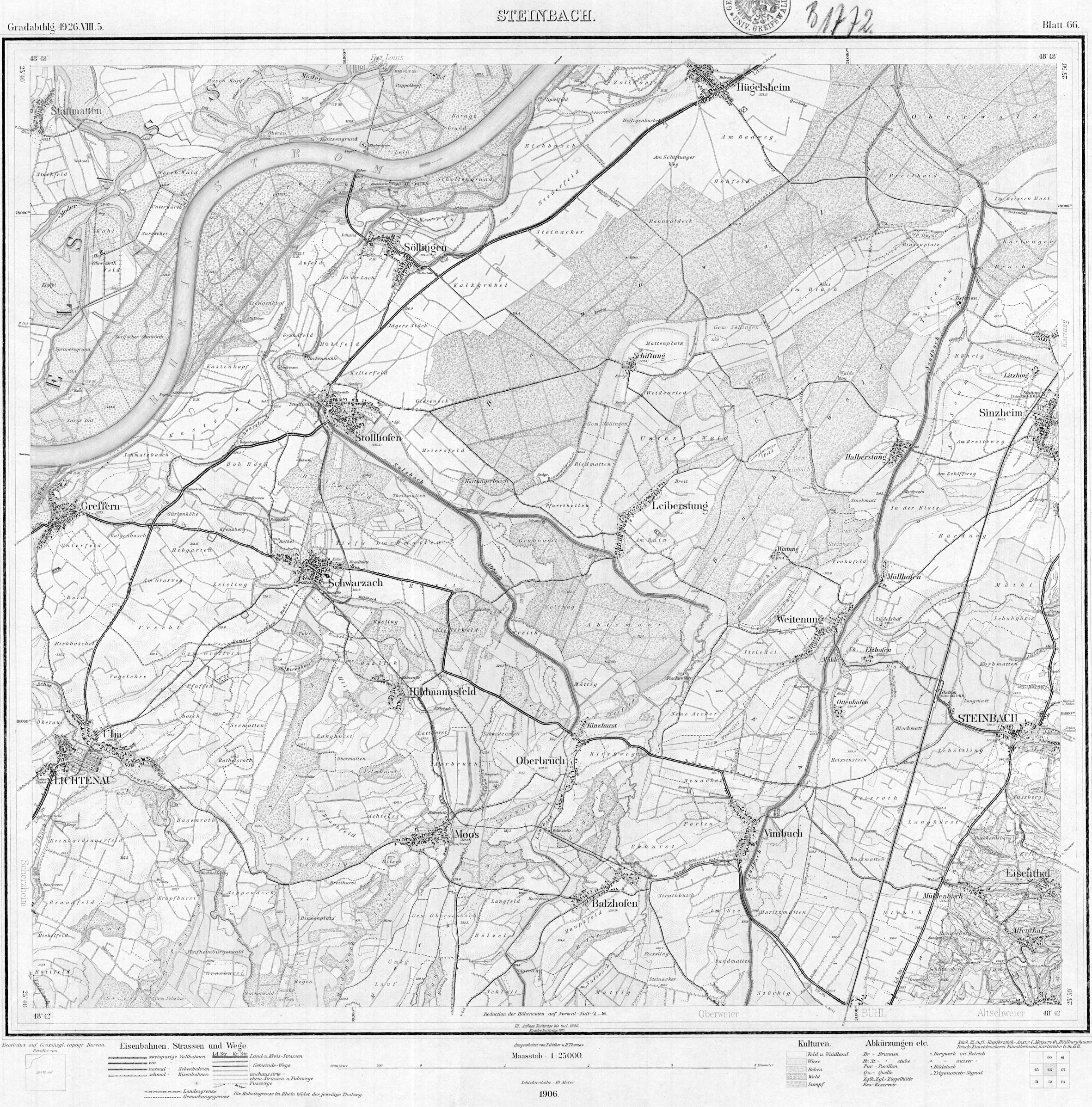
- Ordnance 7214 Steinbach 1906 in the collection GeoGREIF the University of Greifswald.
- Measuring table sheet 7214 Steinbach from 1937 (supplemented in 1951) in the German Maps Collection of Brigham Young University .
- Measuring table sheet 7314 Bühl from 1937 (supplemented in 1951) in the German Maps Collection at Brigham Young University.
- ^ HG Zier: The economic history of the Ortenau in the 19th and 20th centuries. In: Die Ortenau , ISSN 0342-1503 , 40 (1960) pp. 252-320, here p. 280 ( digitized version ).
- ↑ Eugen von Müller: The Bühl-Stollhofener line in 1703. In: Journal for the history of the Upper Rhine . Volume 60 [NF 21], 1906, pp. 99-138, here p. 110 f.
- ^ Ernst Gutmann: City History Stollhofen. The history of the former official city and fortress. 2nd edition, Rheinmünster-Stollhofen, circa 2014, ISBN 978-3-00-040123-7 , pp. 318 f, 493.