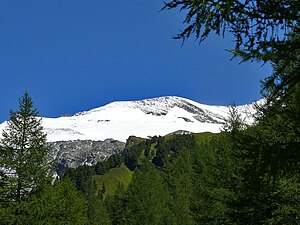
Schneewinkelkopf
| Schneewinkelkopf | ||
|---|---|---|
|
Schneewinkelkopf from the west (Kalser Tauernhaus). |
||
| height | 3472 m above sea level A. | |
| location | Carinthia and Tyrol , Austria | |
| Mountains | Glockner Group , Hohe Tauern | |
| Dominance | 0.75 km → Romariswandkopf | |
| Notch height | 60 m ↓ Schneewinkelscharte | |
| Coordinates | 47 ° 5 '52 " N , 12 ° 39' 37" E | |
|
|
||
| rock | Prasinite | |
| First ascent | September 14, 1869 by Johann Stüdl and Karl Hofmann , with the mountain guides Thomas Groder and Josef Schnell | |
| Normal way | from the Oberwalder Hütte over the Obere Pasterzenboden, the Schneewinkelscharte and the southeast ridge to the summit as an alpine tour | |
The Schneewinkelkopf is a mountain of the Glockner group consisting of two peaks in the western Tauern main ridge , a mountain range in the Central Alps . It lies exactly on the border between the Austrian federal states of Carinthia and East Tyrol . The main summit has a height of 3472 m above sea level. A. on. The two peaks are about 200 meters apart and connected by a ridge running from northwest to southeast, part of the Glocknerkamm. There are no other ridges. Seen from the northeast, the Schneewinkelkopf appears like a flat arched cathedral covered by firn , the rock only emerges on its southwest side. From the north-west, on the other hand, it looks like a snow pyramid with firn walls sloping up to 80 °. The points of the two peaks are hidden under snow. The head was first climbed on September 14, 1869 by the Munich alpinist Karl Hofmann and the Prague merchant and co-founder of the German Alpine Club Johann Stüdl . They were run by Thomas Groder and Josef Schnell from Kals am Großglockner .
Surroundings
The Schneewinkelkopf is located at the northwest end of the Glocknerkamm. It is completely surrounded by glaciers . In the northeast, the so-called snow angle, which belongs to the nutrient zone of the Pasterze , the largest glacier in the Eastern Alps , extends up to the summit ; to the southwest lies the Laperwitzkees . Neighboring mountains in the northwest ridge are the Eiskögele with a height of 3423 m and along the firn-covered Glockner ridge, to the southeast, separated by the Schneewinkelscharte at an altitude of 3412 m , the Romariswandkopf ( 3511 m ). Other mountains in the course of the ridge are the Glocknerwand with its seven towers and beyond the Untere Glocknerscharte (3596 m) finally the Großglockner . To the west, the Schneewinkelkopf falls beyond the Aderwand into the Dorfer Tal , the northern extension of the Kalser Tal . The nearest major settlements are the well 10 kilometers in a straight line south to East Tyrol situated Kals am Grossglockner and about 20 kilometers to the north lies Kaprun in Salzburg 's Pinzgau .
Bases and tours
The route of the alpinists in 1869 led from the Schneideralpe , at today's Kalser Tauernhaus in the Dorfer Valley, in very cold and icy northern storms, but bright weather, over the steeply sloping and crevice-rich Laperwitzkees and the southeast ridge to the highest point. It took five hours to climb. The descent led down to the Pasterze and after three and a half hours you were in the Hofmannshütte , the historic accommodation of Archduke Johann of Austria , which Karl Hofmann had rebuilt in 1869. The base for today's normal route is the Oberwalder Hut (2972 m), northwest of the Franz-Josefs-Höhe . The path leads as a serious alpine tour , with appropriate equipment and glacier experience, from the hut first in a north-westerly, then westerly direction over the crevasse Pasterze to the Upper Pasterzenboden and then south to the Schneewinkelscharte. From there you can walk over the southeast ridge to the summit in around three hours. Further ascents are possible over the south ridge , which is covered with blocks , through the rocky west wall and the other walls of the head covered with firn. The routes require climbing skills of the UIAA II level of difficulty . The ice slope of the walls varies from 40 to 80 °.
Literature and map
- Willi End : Alpine Club Guide Glockner Group , Bergverlag Rother , Munich 2003, ISBN 3-7633-1266-8
- Eduard Richter : The development of the Eastern Alps , III. Volume published by the German and Austrian Alpine Club, Berlin 1894
- Alpine Club map 1: 25,000, sheet 40, Glockner group
Individual evidence
- ↑ Federal Office for Metrology and Surveying Austria: Austrian Map online (Austrian map 1: 50,000)
- ^ Journal of the German and Austrian Alpine Club , Volume II, Munich 1871, p. 394
- ↑ Eduard Richter: The development of the Eastern Alps , III. Volume, Berlin 1894, p. 190 f.
- ↑ Willi End: Alpine Club Guide Glockner Group , Munich 2003, p. 326 ff., Margin no. 1151 ff.

