Schreventeich
|
Schreventeich
City of Kiel
Coordinates: 54 ° 19 ′ 41 ″ N , 10 ° 7 ′ 5 ″ E
|
|
|---|---|
| Area : | 2.47 km² |
| Residents : | 11,878 (Dec. 31, 2014) |
| Population density : | 4,803 inhabitants / km² |
| Postal code : | 24116 |
| Area code : | 0431 |
|
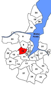
Location of Schreventeich in Kiel
|
|

The Kiel district of Schreventeich lies between the districts of Hasseldieksdamm or the municipality of Kronshagen in the west and the districts of Exerzierplatz and Damperhof in the east. To the north, the district borders on the Ravensberg district with the Stinkviertel , and to the south on Südfriedhof .
District boundaries
The district of Kiel-Schreventeich currently (2010) has the following borderline, beginning in the north and continuing clockwise. The border is formed by Eckernförder Strasse and Gutenbergstrasse in the north, and then runs along Knooper Weg, Kloppstockstrasse, Goethestrasse and Sternstrasse in the east. In the south, Stephan-Heinzel-Strasse and Hasseldieksdammer Weg form the border, in the west the B76 and Olof-Palme-Damm. Then the border leads to the northwest along the Kronshagener Weg. From here, the district boundary coincides with the city boundary to Kronshagen, which runs west of the allotment gardens next to the B76 to the cemetery, then along the Eschenkamps, west of the crematorium along the Aschauweg to Eckernförde Strasse.
The Schreventeich
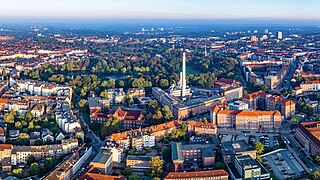
The pond in the east of the district was formed by ice ages . The pond was previously far outside the city and was owned by the local count and was therefore popularly called "des Count Teich", which in Low German at the time was "s grefens diek", the letters were blurred until the current name was created. Gustav Adolf von Varendorf wrote on his card from 1796 the condemnation of the term, Schreventeich. This pond is the namesake of the district.
The park - Schrevenpark
As part of the expansion of the city of Kiel around 1900, a park was planned around the Schreventeich. In 1901 this park was created according to plans by the city gardening director Ferdinand Hurtzig (1872–1939) and named in honor of the Hohenzollern family. From 1901 to 1947 the park was called Hohenzollernpark. The park was badly damaged during the war. Bomb craters had to be filled in again and paths restored. The park was redesigned in a greatly simplified manner and on December 17, 1947, by resolution of the council meeting, the name was changed to Schrevenpark, based on the Schreventeich. On the occasion of the draft resolution, the then councilor and later mayor Hermann Köster (SPD) said that there are of course more important things today than such renaming.
Humboldtstrasse thermal power station (HKWH)
The Humboldtstrasse thermal power station (often abbreviated as HKWH) is at the southeast end of the district. It has been converting natural gas and heating oil into electricity since 1901 and into district heating since 1907. It had a total output of 60 MW (heating water network) plus 157 MW (steam network), in 2018 it is specified with 155 MW heating water network and 21 MW electricity generation.
The power plant went into operation on October 15, 1901. The wrought-iron switching platform and staircase were made by the renowned Berlin art blacksmith's workshop Eduard Puls .
With this power plant, the Stadtwerke Kiel started the power supply and from 1907 supplied two schools with the first Kiel district heating . It has been extensively modernized several times.
It has been the second largest power plant for district heating in Kiel since 1970. From 1970 to 2019, the coal-fired joint power plant in Kiel exceeded 295 MW of thermal output and, after its shutdown in 2019, was exceeded by its replacement new building, a gas engine power plant with 190 MW of thermal output.
The chimney of the power plant can be seen from afar and only emits smoke when it is in operation, which since 2017 has only been the case when there is a very high heat demand and / or failure of the largest power plant in Kiel.
The steam technology (180 ° C) was supplied exclusively by this power plant for the Kiel district heating network from 1907 until it was abolished in 2017. At the end of 2017, the last household in Kiel was also converted to heating water (120 ° C) technology. This is made available redundantly by various power plants in Kiel.
The water from the Schreventeich was used for cooling the power plant for a long time. At the northeast end of the pond, a small footbridge reminds of the place where the water used to come from to the power station and back. Since 1985 it has been the water cascade at the southeast end that allows the power plant water, enriched with oxygen, to get into the pond.
In 2018, for the first time since 1901, the Schreventeich was frozen to the point that it was accessible.
structure
Statistical data
According to the website of the state capital Kiel , the district had 11,185 inhabitants in July 2007 on an area of 247 hectares.
architecture
The district is very densely built to the east of the West Ring - and mainly in multi-storey (3 to 5-storey apartment buildings) construction. The population density decreases to the west of the west ring, the construction method here is 1- to 2-story (row houses). The residential streets west of the Westring, in particular the area between Kronshagener Weg and Langenbeckstrasse , is also called the Philosophenviertel because two streets are named after the two philosophers Kant and Nietzsche . The quarter dates back to the 1930s and has largely been preserved to this day without any major structural changes.
Infrastructure
In the east of the district there is not only retail stores, restaurants and medical practices, but also the municipal hospital . To the west of the Westring on Kronshagener Weg is the Kiel branch of Deutsche Telekom AG, which has also been the state capital's land registry office in the same complex since 2006. Opposite, on the corner of Sedanstrasse and Kronshagener Weg, the Max Giese construction company , formerly one of the largest companies in the industry in Schleswig-Holstein , had its headquarters until 2003 . After the bankruptcy in 2002, the company premises were divided. A part is still used commercially, the rest became a building area. Today there are row houses in the newly opened Max-Giese-Straße .
Lost Places
The term lost places refers to buildings or areas that have completely disappeared or only exist as ruins and fragments. Their relevance for a district consists in the testimony to historical events that affected its residents:
- The synagogue on the corner property at Goethestrasse / Humboldtstrasse was destroyed in the pogrom night in 1938 . A memorial designed by the sculptor Doris Waschk-Balz has stood at this point since 1989 , in which a memorial plaque that was installed in the same place in 1968 is integrated.
- Lessingplatz underground bunker
- During the Second World War , this bunker was built for 240 people and was badly hit towards the end of the war. It is no longer accessible, the area is now a green area.
- Bunker Sedanstrasse
- During the Second World War , the air raid shelter was of central importance. Today there is a children's playground in the area - only the ventilation structure protrudes from the ground.
- Prof. Peters Platz camp
- Until about 1955, Nissen huts stood here for refugees and, as a result of the Allied air raids, homeless people from Kiel, so-called bombed out.
- Barrack Schrevenpark
- There was a barrack in the park area near Herderstrasse, which was used as a youth home. The location was of central importance for Die Falken and the FT Adler gymnastics club.
See also
Place of residence of well-known personalities

- Christopher Ecker (* 1967), German writer
- Andreas Gayk (1893–1954), Lord Mayor of Kiel: Virchowstraße 2
- Friedrich Hurtzig (1872–1939), City Horticultural Director from 1900 to 1937: Service villa in Freiligrathstrasse
- Margret Knoop-Schellbach , visual artist
- Christa Randzio-Plath (* 1940), member of the European Parliament until 2004
- Karl Ratz (1897–1961), President of the State Parliament
- Heide Simonis (* 1943), Prime Minister of Schleswig-Holstein : Schillerstraße
- Marius Tofte (1894–1969), trade unionist
- Friedrich Wendel (1886–1960), journalist
literature
- Ferdinand Hurtzig: The developments of the urban gardens in the years 1900 to 1937 . Abridged version, ed. by Jörg Matthies, Green Space Office of the City of Kiel 2005.
Individual evidence
- ↑ The population in the Kiel districts in 2014 . (PDF) State capital Kiel
- ↑ a b City map of the city of Kiel published by the city of Kiel with detailed district boundaries
- ↑ The crematorium was decided in 1912 and put into operation in 1916. It was considered the first in what was then the Prussian province of Schleswig-Holstein . This changed in 1937 with the entry into force of the Greater Hamburg Act , in which the previously Free Hanseatic City of Lübeck was incorporated into the province. In their state crematorium in the Vorwerker Friedhof , a test cremation took place on the anniversary of the birthday of the " Heroes Emperor " in 1910.
- ↑ Schleswig-Holsteinische Volks-Zeitung of December 18, 1947, No. 103, o. P.
- ↑ 29. Amendment of the land use plan of the state capital Kiel, version 2000
-
↑ adalbert-gieseler.de
Stadtwerke Kiel, 50 years of power supply (1951)
MAN steam engine list (1902)
Haack: Electrification in Kiel (master's thesis) - ↑ Figures 351 and 352. In: Berliner Architekturwelt , 4th year 1902, Issue 7, pp. 260 f., Accessed on February 21, 2020.
- ↑ shz.de Heating water replaces steam
- ↑ kiel.de zoning plan
- ↑ Margret Knoop-Schellbach: The light shines in the dark . Johannis, Lahr 1997.
- ^ Karl Rickers: The journalist. In: J. Jensen u. K. Rickers: Andreas Gayk . Wachholtz, Neumünster 1974, p. 61.
Web links
- Schreventeich: Quarter with a green oasis - Report by Karina Dreyer on KN-online from September 1, 2012
- Kiel district Schreventeich in the Stadtwiki Kiel


