
Side (Pamphylia)

| |
Side, location in Turkey |
Side (ancient Greek Σίδη) was a city in the ancient Pamphylia countryside . It is one of the archaeological sites that offer a particularly clear overview of the urban infrastructure of an ancient city complex. The city is located around 60 km east of Antalya (ancient Greek Ἀττάλεια Attáleia ) in southern Turkey . The Manavgat Nehri (ancient Greek Μέλας Melas ) river flows nearby . The city, located on a peninsula, has been a prosperous commercial and economic metropolis for centuries with an estimated population of up to 40,000.
Around 900 AD, the residents left the city and moved to Antalya. The urban area was left to its own devices for around a millennium, so that during this period there was hardly any intervention in the ancient building fabric. The archaeological remains visible today date to the Roman to Byzantine times.
Today 's place , officially called Selimiye , was first settled by a group of Muslim emigrants from Crete around 1900. The scientific investigation of the ruins began around the same time and initially remained sporadic. From 1947 to 1966 a comprehensive excavation was carried out by the Archaeological Department of Istanbul University under the direction of Arif Müfid Mansel , which has been followed by numerous detailed investigations up to the present day. Currently (2020) around half a dozen excavation areas are open in the village, including a section of the colonnade road. In Side the touristy life takes place in the midst of impressive ruins and resembles the lively hustle and bustle, as we have to imagine it for an ancient port city.
History of the city
founding
The area of Side extends over a rocky peninsula, which offered ideal conditions for the alluvial plain of Pamphylia with few possibilities for port facilities. According to mythological tradition, Side was founded by Kyme in the 7th or 6th century BC. Settled in the Aeolian coastal city north of Smyrna ( Izmir ), when many secondary colonies were founded in Asia Minor. There was certainly an older settlement at this point. The year 1405 BC, named by the church historian Eusebios (3rd – 4th century) as the founding date. Chr. However lacks any historical basis.
The name Side means pomegranate ; the word is of Anatolian origin. It is a well-known symbol of fertility that we encounter on the city's coins from the early days to the Roman Empire. The Indo-European Sidetic language , which is evidenced by coins and inscriptions, is related to Luwian and is probably the original Anatolian language of Pamphylia. The findings suggest that the number of Greek settlers was fewer than in other colonies and that they were unable to establish their language. In fact, there is no evidence of Greek language prior to the conquest of the Persian Empire by Alexander the Great (334–323 BC), which made Greek the official language throughout the east and the indigenous dialects gradually died out. Greek stone inscriptions in Side can be found since around 300 BC. Prove BC; Greek has been found on coins since the 2nd century BC. Chr.
Hellenism
With the conquest of Alexander, Side and Pamphylia were included in the Hellenistic world in the eastern Mediterranean. After his death, Pamphylia was disputed between the Seleucids and Ptolemies , the cities themselves remained independent. This was shown in 223 BC. When the young Antiochus III. sent an uncle named Achaios to regain Asia Minor, which had fallen into the hands of the King of Pergamon . In the conflict between two cities ( Selge , Pednelissos ), Achaios asked different cities for help. Aspendos was among those who sent troops, the people from Side refused to answer, "partly out of a friendly attitude towards Antiochus, but more out of hatred of Aspendos ". The cities acted freely and of their own accord. Little changed in this in the following decades, which brought about formal changes of ownership - from the Seleucids to Pergamon, from Pergamon to Rome.
In the Roman-Syrian War , 190 BC BC, Side was the scene of a naval battle between the fleet of Antiochus III, commanding Rome's old enemy Hannibal , and that of Rhodes , who fought for Rome. Side supported Antiochus. The sea battle ended in a narrow victory for the Rhodians. Soon after, Side changed sides and signed an alliance treaty with Rhodes. By fighting on the side of the Romans and their allies, the Sidetes were able to gain a privileged status for their city in the peace of Apamea . In the siege of Carthage , Side supported Scipio with five warships (147 BC). The importance of the city in Hellenistic times is also underlined by the fact that Antiochus VII was brought up in Side and was nicknamed Sidetes .
Rome
The Romans, who had been reluctant to send their legions across the Aegean against Antiochus, were not interested in the south coast of Asia Minor until their attention was drawn here by the growing activity of pirates . Side was around 100 BC. Heavily involved in piracy, which spread more and more. Strabon reports on the so-called "pirate time", where Side offered the pirates markets for the sale of (also human) booty and anchorages. When in 67 BC Chr. Pompey piracy put an end, citizens rushed to restore their good name by building him a stately monument and an honor statue. Apparently there was no punishment from the Roman Senate.
During the Roman Empire, Side flourished and became rich, probably more prosperous than most of the cities in the east, without playing a major historical role. From the 1st to the middle of the 3rd century, an era of great wealth, the city was the seat of the provincial governor. Most of the surviving ruins and the structures discovered during the excavations date from these years. The large port, which also served as a naval base, and the Roman roads boosted trade, especially with Egypt. The city itself had a considerable merchant fleet. The imported goods went on caravans to central Anatolia, the export consisted of olive oil, wine and wood. The city also remained a center of the slave trade.
The decline of Roman power in the 3rd century led to a resurgence of piracy. The city was attacked and besieged by Scythian privateers from the Black Sea; she successfully resisted. In addition, there were incursions of the Isaurians from the northern mountains. The result was certainly an impoverishment of both the country and the city. However, whether the residential district in Side was halved in the 4th century by drawing an inner city wall along the narrowest part of the peninsula, or whether this only happened 300 years later, cannot be determined with certainty (more details in the chapter on city fortifications).
Byzantium
The 5th and 6th centuries brought better times. The city repopulated. The buildings, especially the theater, were restored; a forum of Arcadius (395-408) was created outside the main gate. In early Byzantine times, the metropolitan of Side was ranked tenth, later thirteenth place within the Patriarchate of Constantinople ; fifteen episcopal cities were under him. With the advance of the Arabs from the 7th century onwards, final decline began. Arab pirate attacks turned the entire Anatolian Mediterranean coast into a war zone. At the same time the port silted up. The inhabitants began to move to the better protected Antalya, which took on the role of Side as the most important port city of Pamphylia.
The plant of the city


The prosperity and the entire urban life of the city rested on three basic prerequisites: the city fortifications protected against external hostility; the port was the gateway for trade and communication and thus a transshipment point for goods and news; the aqueduct guaranteed an abundant supply of the vital element. Only on this basis could urban life develop, as it is characteristic of the Roman Empire: with magnificent streets and squares, with shops, shops and taverns, with fountains and baths, with the theater, with sports and educational facilities, with lavish ones Temples and - in Christian times - churches. The most important buildings were built in marble, which had to be transported by sea because there are no suitable quarries nearby.
The city fortifications

Because of its flat location, Side needed strong fortifications. The land wall, the main gate and the east gate formed a uniform belt of fortifications about one kilometer long in the north and east of the city. The wall has been partially preserved up to its original height; in the south it is covered with sand. The outside of the wall consists of regular ashlar and is unusually decorated with a pure decorative cornice. The inside is divided into three cantilevered floors so that two defensive corridors are formed. The entire wall system belongs to the Roman period, probably in the 1st / 2nd centuries. Century AD. The sea wall along the shore zone is mostly completely destroyed, the remains are byzantine overformed.

There is also a second wall, about 350 meters long, the so-called Philippus Attius wall according to a built-in inscription . It runs in an irregular line at the narrowest part of the peninsula, is more carelessly constructed than the main wall and cuts the city in half. Many set pieces from other buildings ( spoils ) such as column drums, marble blocks etc. were built in and bricks and mortar were used extensively. Perhaps it was built in the 4th century when the mountain tribes from the Taurus invaded Pamphylia several times and plundered. This is said to have led to the decline of the city, which only slowly recovered. However, as written sources report, a Roman legion was stationed in Side at the time, and the attackers were repulsed and driven away each time before they reached the city wall. Clive Foss also interprets the wall as a defensive wall, but dates it to the 7th century, when Persian and Arab attacks were to be expected, especially by Arab pirate fleets. The wall may also come from a later time.
From 2013 onwards, a project by the German Archaeological Institute should provide reliable dating and information about the urban function of the wall. For this purpose, the wall was examined intensively for the first time from a structural engineering point of view over about half its length. An unexpectedly long history of building and renovation emerged, at least from the early Roman to the Middle Byzantine period.
The harbor
Side's wealth was based on the benefits of his fertile land and trade. The importance of good harvests for the well-being of the city is expressed in several inscriptions. Above all, Side was an important port city that maintained a large fleet of merchant and warships, as suggested by the widespread circulation of sidetic coins depicting ships and ports. In the northern book, smaller ships with shallow drafts and boats can anchor, but not larger watercraft. The citizens of Side therefore built an artificial harbor at the tip of their peninsula in order to carry out extensive sea trade. They dug a triangular basin and in front of it built a pier out of conglomerate blocks over which they drew the city wall. There were two driveways and a lighthouse.
The harbor basin was considerable: 25–30 ships could, if they moored alongside the quay, land or take goods on board at the same time. At the northwestern tip, a second artificial harbor basin with an entrance was created by moles, which was probably used primarily as a naval port. In Roman times, Side was a base for the Roman navy. To the east of the large basin of the “war port” there were several small roads for not too large ships and boats, including fishermen. The docks and shipyards mentioned by Strabo were probably also on the north side of the headland. Sides harbors suffered, like all artificial structures of this type, from continuous silting up. The harbor basin had to be cleaned constantly. The Melas, which washes its erosion materials into the sea and piles sand dunes in front of its mouth, is to blame for the silting up of the port. With a southeast wind, the wind carries the sand into the city and into the harbor, so that today the southeast quarter of the ruins of Side is buried under a sand dune several meters high.
Side was at the crossroads of the sea trade routes between Asia Minor, Cyprus , the Levant and North Africa. There were two sea routes to the west from Side: one route went along the coast, another across the gulf to the southern tip of Lycia , which you only risked in good weather. Another sea route ran from Side to the northwest tip of Cyprus, to Cape Akamas . This is part of the busy sea route Side - Alexandria , through which the intensive contacts between the two cities were handled. The importance of the port is also evident from the fact that in the 2nd half of the 3rd century AD it served as a supply and operational base for the Roman troops involved in the Roman-Persian wars , and Side therefore earned the honorary title of "Nauarchis" ( Mistress of the Fleet).
The water pipe

The long-distance water pipeline has been well researched and the construction time is assumed to be in the 2nd half of the 2nd century AD. In its upper course, the Melas River flowed through a narrow gorge, in which the Dulamnı spring came to light, the strongest karst spring in the world with a flow rate of 50 cbm / s. The Roman engineers connected the line to this source. Today the source is covered by the Oymapınar reservoir . The natural gradient was used to transport the water. The difference in altitude to the city was only 36 m, the straight line 25 km. So the route could not circling a large hill, the engineers had to run the line on as straight a route as possible. It was finally 30 km long, with an average gradient of 1.2 per thousand, with which the Roman engineers remained in the lower range of their technical possibilities.
In the gorge, three aqueduct galleries were built, deep, open gullies carved into the rock face. Around 13 km had to be developed as a tunnel section. In addition, more than 20 aqueduct bridges, some of which were monumental, were necessary to span the Melas side valleys and depressions. Today, the remains of the river are clearly visible and picturesque in the landscape. The mouth holes of the tunnels and the vertical shafts above the tunnel route necessary for the advance can also be found for the most part.
Shortly before reaching the city walls, there was a distribution structure with a branch to the nymphaeum (see following chapter) in front of the city gate. The branch leading into the city broke through the city wall at a certain height and continued laterally to the vicinity of the theater, where the water was collected in a large cistern. From there the fountains and baths of the city were supplied
The goals
The main gate, today located behind the large parking lot and the bus station, leads visitors into the city today as in the old days: in the middle, as in Perge, there is a semicircular courtyard with an outer and inner gate, flanked by two large towers of the city wall. The remains are in a bad state of preservation. The courtyard was richly decorated with pillars, niches and statues on two floors: numerous architectural fragments and the statues found are exhibited in the museum.
Opposite the main gate - outside the city wall - is the Nymphaeum (A), a building like the one in Aspendos , but more splendidly furnished. The front of this monumental fountain was 52 meters wide. The original splendor of the former marble facade with numerous columns, with decorative figures and reliefs has disappeared today; however, the building is still halfway up. The complex consisted of a high, three-story facade with protruding wings and enclosed a large water basin ten meters wide. The water streamed from three niches from marble pipes into the basin, in front of which there were other smaller basins. Between the pool and the gate there was a large square paved with stone slabs.

In the 1960s, a second gate, known as the East Gate, was uncovered and has since been carefully examined. The layout of the facility is different from the main gate. The gate can be entered from the outside through two barrel- vaulted passages flanked by two rectangular towers. One arrives at an approximately 17 × 17 m large courtyard, from which three further passages lead into the city center. On the outer walls of the courtyard facing the city, two stairs lead to the battlements or to a terrace or attic . A number of reliefs depicting weapons were found there: swords, helmets, breastplates - possibly depictions of captured items. They form a kind of frieze and are now placed in the museum courtyard. In later times (at least until the 7th century AD) the facility was redesigned several times and used at times for private purposes.

In Roman times, where the street reaches the theater, a high-arched arch building that still stands over 12 meters spanned the Inner City Gate (I). The monumental arch probably originally carried an emperor's statue with a team of four, because inscriptions with the name Quadriga-Viertel were found in the area. As the city shrank, this building became the main entrance. The arch was filled with masonry, through which a small gate led. In the meantime the passage has been opened a little again, the numerous spoilage in the remains of the wall, here mainly column drums, show that abandoned buildings were extensively used as quarries.
To the left of the gate is the monument of Vespasian , which was moved here from another place when the inner wall was built and used again as a fountain. In a semicircular niche, water flowed into a small basin, on both sides there were so-called aedicules , each with two fluted columns and a statue. The three parts of the monument were crowned by cornices and triangular gables. To the right of the gate, on the opposite side of the street, the remains of two other wells can be seen.
The streets and alleys

Two wide colonnaded streets (K) led into the city from the main gate. One branches off to the left in a southerly direction. The marble-paved street was lined on both sides by raised colonnades , on which shops were lined up. A narrow pool of water ran in front of the eastern row of columns, and a water channel under the street.
The second columned street, the main axis, led with various kinks to the large square between the temples by the sea. It, too, was splendidly decorated with porticos and marble paving. Today the road runs here to behind the theater. Here, too, some truncated columns have been rebuilt, and the former shops have been exposed on both sides over a longer stretch. The rear section is now built over with village houses.
A few meters before the Handelsagora, an alley branches off to the left, where the foundations of several private houses have been exposed (including the Peristyle House and the Console House), which were connected to the main street's sewer system via the alley. The two-story console house has a large inner courtyard (16 × 16 m) around which the rooms are grouped.
Apart from a few broad main streets, the cityscape was dominated by narrow streets. They met at an oblique angle, as has been characteristic of the cities of the Mediterranean at all times. The properties enclosed by these alleys, the insulae , were therefore of irregular shape.
Side was divided into districts, which owed their names to important monuments (for example Quadriga district, see above). Four parts of the city are attested in writing. They played a certain role in the internal administration of the city.
The places

Immediately in front of the theater is the Handelsagora, the market square. The open complex, 65 meters long, was surrounded on all sides by colonnades with a flat wooden roof, behind which the shops were lined up. On the side where the stoa leaned against the theater's stage there were seven vaulted rooms, five of which led into the theater. Some of the granite columns have been put up again, otherwise there are other columns and marble architectural elements in an orderly manner on almost the entire - now cordoned off - square. You entered it from the street through a monumental gate of which only the foundation walls have remained.

As in other cities, Side's market square not only served as a shopping center, but also as a meeting place for citizens who passed their time there. Life in antiquity largely took place outside the home; the agora was populated daily, especially in the morning hours. “When the agora is visited” - that was the Greek expression for the morning hour. The remains of a round temple can be seen near the center of the square (T4, see below). A semicircular latrine building was leaning against the supporting wall of the theater in the south-west corner of the square. A sewer ran under the 24 seats, and another channel in front of the seats supplied fresh water for cleaning. The walls were covered with marble slabs of different colors, the barrel vault was adorned with a mosaic. Facing the agora, this magnificent building had a large niche for a statue. The latrine could be entered through low doors not only by passers-by in the agora and the Säulenstrasse, but also by theater-goers.
Another square of similar size and construction was located south of the Handelsagora. It was connected to the trading agora by a wide paved road. The south wall of the agora with the stoa and the shops in between were destroyed during the construction of the Philippus Attius wall. Two smaller gates were broken in the corner to the sea.

Leaning against the eastern side of the square is a larger building with three adjacent halls, of which the middle (26.45 × 15.20 m) is larger than the side (19.5 × 15 m). The importance of the hall was emphasized by the protruding pillars of the courtyard. Three walls on two floors were extremely richly decorated with niches and tabernacles in which statues stood. From the lower row, 20 larger-than-life specimens could be recovered, some in good condition. Excavator AM Mansel interprets the complex as an imperial hall dedicated to the imperial cult with an adjoining library or archive room, the space in front of it could be interpreted as a state agora.
The theater
The theater towers over all the ruins of Side and is one of the largest in Asia Minor. In its present form it belongs to the Roman period (2nd century). The layout of the auditorium, which extends significantly beyond a semicircle, is the best proof that a Hellenistic theater originally stood here. During excavations, two steps from the Hellenistic period were found in the lower spectator area, which are now protected under glass.

Since the location of Side is flat, there was no hill into which the theater could be built, as for example in Aspendos. A slight incline found here was hardly enough for the lower half of the auditorium. The upper part had to be erected as a huge open-air building. This still stands over 15 m high on two floors, originally it was two to three meters higher.
The semicircle of the spectator area, the cavea, is horizontally divided into two parts and can hold around 15,000 people. Both parts had 29 rows of seats each, in the upper cavea only 22 remain. 12 stairs below and 25 above, in connection with the galleries of the barrel vault, in which there were also shops, ensured that the audience could take their seats and leave the venue as quickly as the crowds in a modern football stadium.

The stage building was three-story, 63 m wide and was lavishly clad with marble. The actors acted on a six-meter-deep and three-meter-high stone platform that was in front of the stage facade and was accessed from there through five doors. The friezes on the first floor of the stage house showed reliefs from the life of Dionysus . A Christian chapel was added to the side in Byzantine times, creating a kind of open-air church. The sensual Dionysus reliefs no longer matched and were chiseled off. When the city restructured itself in the 4th century, the stage was included in the new city wall.
The semicircle of the orchestra is located between the stage and the auditorium. The ground consists of tamped earth, around which a water channel runs. The rainwater was drained through a canal system. In the late Roman period, the orchestra was converted into a water basin in which sea battles were re-enacted. In cities that did not have their own amphitheater , gladiators also appeared in the theater alongside actors.
Not only the stage of the theater was lavishly decorated with reliefs and sculptures. Like other cities in the Roman Empire, Side was largely shaped by statues . A large part of the more than 400 surviving sculptures and fragments can be assigned to the so-called ideal sculpture, i.e. depicting gods, heroes or athletes; The emperors and deserving citizens also received statues in public spaces. These were found on various buildings within the city, such as the theater, the large nymphaeum at the city gate, the Vespasian monument or the so-called Imperial Hall. There alone were nine preserved statues of gods and five of athletes. Most of them are replicas of well-known Greek sculptures.
The baths

The Agorabad (B1), which was probably built in the 5th century AD, is located in front of the inner city wall, directly opposite the trading agora on the edge of the colonnaded street. The excavations have been completed here and the building has been restored. It has been used as a museum since 1962. In five rooms of different sizes there is an impressive overview of the works of Hellenistic-Roman art found in Side. Particularly noteworthy are the statues recovered in the imperial hall, copies of classical art, as well as the richly decorated sarcophagi from Roman times. Towards the bay is the palaestra , which was used for exercise. Today it is a museum garden with numerous exhibits.

The large bathroom (B2) is located on the eastern edge of the southern columned street and was the largest of the bathrooms with eight rooms of different sizes. Much of the walls have been preserved. Numerous basins can be seen, that of the cold room ( frigidarium ) has a size of 12.40 × 5.40 m. As in all Roman baths, the warm rooms were heated by hypocausts (underfloor heating), which can be seen indirectly from sunken floors. The bath was probably built in the 3rd century AD and in the 5th / 6th century AD. Restored in the 17th century AD. Some doors were bricked up and a large wall was drawn in. The bath is not officially accessible, but can be entered from the adjacent courtyard of a restaurant.
The Hafenbad (B3) got this name because it was located on the now silted up corner of the harbor. It consisted of three larger rooms and a number of smaller ones. The bath was built in the 2nd century AD, making it the oldest thermal bath in Side.
The temples

In Roman times, the image of every city was characterized by numerous temple buildings. In Side, the two main temples (T1) stood next to the harbor on a raised platform, close to the sea. With their rows of columns, the decorated beams and the gables, all made of light marble, they must have left a lasting impression on the sailors who sailed towards them. Its state of preservation is poor, as the destruction began in Byzantine times and has continued into modern times. Its construction followed the widespread type of a peripteros : a brick cell with an anteroom was surrounded by a corridor with a column wreath. Both temples had 6 pillars on the narrow sides and 11 on the long sides. Which deities the temples of Side were dedicated to could not be clearly clarified by inscriptions or other finds. But one can answer this question with a high probability for all five temples of Sides. The two main temples were therefore dedicated to the main deities of the city, the larger one facing the port to Athena , the second to Apollo . During the restoration of the better preserved Temple of Apollo, five columns, parts of the entablature and a corner of the pediment were put back up.
In front of the main temples, that is, on the land side, there was a larger square, onto which the street of columns led. Another temple (T2) with an unusual semicircular floor plan that follows Syrian models was located near its mouth. A wide flight of 14 steps led to the platform, in front of which there were four pillars. Behind it was the straight wall of the front with a door. The interior was arched. Based on a bust in the gable area, it is assumed that this is a temple of the moon god Men , whose cult for Side is attested by a coin.
These three temples weren't the only ones in Side. At the theater, where the street of columns bends at right angles around the corner, there was a small temple (T3), which was certainly dedicated to Dionysus (see the Dionysus frieze on the stage). It was later used as a shop. The marble blocks of the podium are clearly visible from the street.
A round temple (T4) stood in the middle of the trading agora. The platform could be reached via nine steps. The cella was also round and surrounded by 12 columns, the roof pyramidal. The total height was 15 m. Such a temple is depicted on coins from Side, which proves that the cult of the Tyche existed on site and the temple was dedicated to the goddess of fate. He has also been partially raised again.
There were certainly other temples in Side. Above all, there must have been a place for the imperial cult, the priests of which are often mentioned in inscriptions. According to the inscriptions, there were also several synagogues in the city , but their location is not known.
The necropolis
Outside the land wall of Side is the extensive necropolis . During his excavations, AM Mansel came across various types of grave shapes, from simple earth pits to stately mausoleums . These belong mainly to the Roman imperial era, although the necropolis was also heavily used in the Byzantine period and provided with grave monuments.

The main finds are the sarcophagi ; several showpieces are presented in the museum. Two erotic sarcophagi deserve special mention, a "Pamphylian" next to an Attic one. There were also grave altars and various fragments of a larger grave temple complex.
At present, almost the entire area of the necropolis is covered by dunes, from the mass of sand only a few remains of walls protrude.
Byzantine buildings
Side was an important and densely populated city in Byzantine times. As the seat of a bishop, the city experienced a final boom in the 5th and 6th centuries AD and had several large churches. The south basilica (Y1) is located right next to the double temple, which was at least partially integrated into the forecourt ( atrium ). While the north wall of the inner courtyard with seven arched niches is still upright, the south wall was only partially built. The interior has three aisles with a size of about 35 × 25 m. Several side rooms adjoin the eastern end. At a later time, a small church was placed in this large basilica, which must have been dilapidated in the meantime, which is still largely preserved.
A second, monumental basilica is located on the second columned street, about 200 m away from the main gate. It is to be understood as a bishop's basilica (Y2) and the adjoining buildings as a bishop's palace. She had three ships of around 37.50 m in length. Important buildings are attached to this basilica, which is mostly built from spoils from earlier Roman architecture. Below is a monumental baptistery , consisting of three rooms that are connected to one another and the walls of which are richly furnished with angular and semicircular niches. In the south there was a number of rooms lined up next to one another (Y) and on the opposite side of the column street another, smaller church.
The third large basilica (Y3) is located near the theater, between the street of columns and the northern sea wall. Only the eastern facade has been preserved. Since the terrain slopes to the west, the superstructures on this side apparently stood on mighty sub-construction spaces that are visible today from the riverside path.
In addition to these sacred buildings, some buildings of profane use have also been exposed. Particularly noteworthy is a rectangular building east of the great colonnaded street, which is well preserved on two floors ( Byzantine Hospital Y4). The five adjacent rooms are barrel-vaulted, and some of the walls have frescoes. In the 6th century AD, Emperor Justinian I had a hospital built in Side; probably this is the building. In addition, parts of a well-preserved house (Y5) are still standing near the southern sea wall. It occupies an entire insula measuring 35.50 × 14.50 m and consists of a large forecourt and the rooms behind it, which are roofed with brick vaults.
literature
- I. Akan Atila: Antique Itinerary SIDE . no year
- George E. Bean : Asia Minor. Volume 2: Turkish south coast from Antalya to Alanya ( art and travel guide to the classical sites ). 3rd edition, Kohlhammer, Stuttgart / Berlin / Cologne 1985, ISBN 3-17-008796-7 , pp. 70-92.
- Hartwin Brandt , Frank Kolb : Lycia et Pamphylia. A Roman province in southwest Asia Minor. Philipp von Zabern, Mainz 2005, ISBN 3-8053-3470-2 .
- German Archaeological Institute 2012–2016: The ›Attius Philippus Wall‹ in Side, Pamphylia ( online ).
- Clive Foss: Attius Philippus and the Walls of Side . In: Journal of Papyrology and Epigraphy . Volume 26, 1977, pp. 172-180 ( digitized version ).
- Klaus Grewe : The Roman aqueduct to Side (Turkey) . In: Ancient World. Volume 25, 1994, Issue 2, pp. 192–203 ( digitized version ).
- Dietrich OA Klose : Side / Selimiye. in: Kai Brodersen et al. (Ed.), Ancient sites in the Middle Ages. Metzler Lexicon. JB Metzler, Stuttgart, Weimar 1999, ISBN 3-476-01608-0 , pp. 611-616.
- Ute Lohner-Urban: The “Hellenistic Flower” in Side and Tavium from an archaeological point of view. In: Renate Lafer, Heimo Dolenz, Martin Link (eds.): Antiquitates variae. Festschrift for Karl Strobel for his 65th birthday (= International Archeology, Studia honoraria. Volume 39). Marie Leidorf, Rahden (Westphalia) 2019, ISBN 978-3-89646-558-0 , pp. 199-209 ( online ).
- Ute Lohner-Urban: The east gate of Side - a dead end in late antiquity . In: Forum Archaeologiae 77 / XII / 2015 ( online ).
- Arif Müfid Mansel: The ruins of Side. De Gruyter, Berlin 1963 ( partially digitized at Google Books ).
- Johannes Nollé : Side in antiquity. History and testimonials. 2 volumes (= inscriptions of Greek cities from Asia Minor . Volume 43–44). Habelt, Bonn 1993/2001, ISBN 3-7749-1932-1 and ISBN 3-7749-2964-5 .
- Johannes Nollé: Side. On the history of a city in Asia Minor in the Roman Empire as reflected in its coins. In: Ancient World. Volume 21, 1990, pp. 244–265 ( digitized version ).
- Manuel Reimann: The statuary decoration of the Roman city of Side in Pamphylia . In: Forum Archaeologiae 89 / XII / 2018 ( online ).
Picture gallery
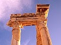
The Temple of Apollo at sunset

Bronze coin from Side, 1st century BC. BC, Athenakopf
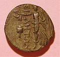
Back: Nike with wreath and pomegranate

Theater, exterior view

Column street south

Yüksekkemer Aqueduct Bridge


Individual evidence
- ↑ Mansel, p. 189 ff.
- ↑ On this and in the following: GE Bean, p. 70 ff.
- ^ Bean, p. 72.
- ↑ Mansel, p. 6.
- ^ Bean, p. 73.
- ^ Bean, p. 73.
- ^ Bean, p. 74
- ↑ Lohner-Urban 2019, p. 203.
- ↑ So Mansel, whom most archaeologists followed.
- ^ Foss, p. 180.
- ↑ Project description / results, see list of references: DAI.
- ↑ Brandt / Kolb, p. 70.
- ↑ Nollé 1993, pp. 25 ff.
- ↑ Brandt / Kolb, p. 68
- ↑ last by K. Grewe.
- ↑ cf. Photo by Mansel, p. 45.
- ↑ Lohner-Urban 2015.
- ↑ Mansel, p. 157ff.
- ↑ Mansel, p. 120 f.
- ↑ Reimann, s. Bibliography.
- ↑ Mansel, p. 173 ff.