Straussmühle (Deining)
|
Ostrich mill
Deining municipality
Coordinates: 49 ° 12 ′ 53 " N , 11 ° 32 ′ 4" E
|
|
|---|---|
| Height : | 455 m above sea level NHN |
| Residents : | 4 (Jan. 1, 2017) |
| Postal code : | 92364 |
| Area code : | 09184 |
|
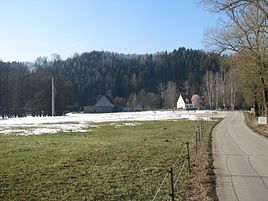
Straussmühle from the east
|
|
The Straussmühle is part of the municipality of Deining in the Neumarkt district in Upper Palatinate in Bavaria .
location
The wasteland lies in the Upper Palatinate Jura south of Deining on the left of the Weißen Laber .
history
The mill has been traceable as "Goldmannsmuhl" since 1450; the millers were Kunigunde and Leonhard Arnold. In the 16th century the miller Pallabeckh sat on the mill, in 1649 Hans Polster, who was struck by lightning in his room that year, and from 1833 Johann Kaiser. His descendants still own the Straussmühle today. Up to the end of the Old Kingdom (around 1800) the manor held the ecclesiastical administration of Neumarkt; the high jurisdiction lay with the electoral mayor's office in Neumarkt.
In the new Kingdom of Bavaria (1806), a widely spread tax district of Deining was formed in the Neumarkt district court in Upper Palatinate , to which the Straussmühle was also assigned. With the parish edict of 1818 the (smaller) parish of Deining was formed, to which the parish village of Deining itself and the three mills Büglmühle , Roßamühle and Straussmühle belonged.
The repertory for the topographical atlas sheet Neumarkt reported in 1836: "Straussmühle, E [inöde] bey Deining, 1 H [aus], 1 Mühle, (1 grinding) at Lengenbach." As usual, the mill also included an agricultural operation; so in 1875 Straussmüller kept ten cattle in addition to four horses.
In 1959 the mill was shut down. The sawing business was maintained for a few years. The farm was organized around 2000 under the owner Manfred Kaiser according to the guidelines of organic farming.
Population development
- 1830: 6 (1 house)
- 1875: 14 (5 buildings)
- 1900: 12 (2 residential buildings)
- 1925: 3 (1 residential building)
- 1950: 12 (1 residential building)
- 1961: 9 (1 residential building)
- 1987: 1 (1 residential building, 2 apartments)
- 2017: 4
Transport links
The mill can be reached via a spur road that branches off from state road 2220 to the west about one kilometer south of Deining.
monument
The mill house, a two-story pitched roof building with a plastered half-timbered gable, which dates from the first half of the 19th century, is considered a monument.
See also the list of architectural monuments in Deining # Straussmühle
literature
- Bernhard Heinloth: Historical Atlas of Bavaria. Part Altbayern, Issue 16: Neumarkt , Munich: Commission for Bavarian State History, 1967
Individual evidence
- ↑ History of the mill on deining.de ( Memento of the original from March 4, 2016 in the Internet Archive ) Info: The archive link was inserted automatically and has not yet been checked. Please check the original and archive link according to the instructions and then remove this notice.
- ^ Kurt Romstöck (text) and Alfons Dürr (drawings): The mills in the district of Neumarkt id Opf. , Neumarkt id Opf. 2004, p. 221
- ↑ Heinloth, p. 282
- ↑ Heinloth, p. 321 f.
- ^ Repertory of the topographical atlas sheet. Neumarkt , 1836, p. 30
- ↑ a b Kgl. Statistical Bureau in Munich (edit.): Complete list of localities of the Kingdom of Bavaria ... based on the results of the census of December 1st. 1875 , Munich 1876, column 881
- ↑ Romstöck / Dürr, p. 221
- ^ Karl Friedrich Hohn: The rain district of the Kingdom of Bavaria, described geographically and statistically , Stuttgart and Tübingen: Cotta, 1830, p. 143
- ↑ Kgl. Statistical Bureau in Munich (edit.): List of localities of the Kingdom of Bavaria ... [based on the results of the census of Dec. 1, 1900] , Munich 1904, column 865
- ^ Localities directory for the Free State of Bavaria according to the census of June 16, 1925 and the territorial status of January 1, 1928, Munich 1928, column 871
- ^ Official register of places for Bavaria edited on the basis of the census of September 13, 1950 , Munich 1952, column 741
- ^ Official register of places for Bavaria. Territorial status on October 1, 1964 with statistical information from the 1961 census, Munich 1964, column 548
- ^ Official register of places for Bavaria, territorial status: May 25, 1987 , Munich 1991, p. 257
- ↑ deining.de: Population on January 1, 2017 ( Memento of the original from September 23, 2017 in the Internet Archive ) Info: The archive link was automatically inserted and not yet checked. Please check the original and archive link according to the instructions and then remove this notice.

