Tambasasayama
| Tamba-Sasayama-shi 丹波 篠 山 市 |
||
|---|---|---|
| Geographical location in Japan | ||
|
|
||
| Region : | Kinki | |
| Prefecture : | Hyogo | |
| Coordinates : | 35 ° 5 ' N , 135 ° 13' E | |
| Basic data | ||
| Surface: | 377.61 km² | |
| Residents : | 39,858 (October 1, 2019) |
|
| Population density : | 106 inhabitants per km² | |
| Community key : | 28221-9 | |
| Symbols | ||
| Flag / coat of arms: | ||
| Tree : | cherry | |
| Flower : | Lilium japonicum | |
| town hall | ||
| Address : |
Tamba-Sasayama City Hall 41 , Kitashin-machi Tamba-Sasayama -shi Hyogo 669-2397 |
|
| Website URL: | http://www.city.sasayama.hyogo.jp/ | |
| Location Tamba-Sasayamas in Hyogo Prefecture | ||
Tambasasayama ( Japanese 丹波 篠 山 市 , Tamba -Sasayama- shi , alternative Romanization Tanba ~ ) is a city in Hyōgo prefecture in Japan . Until 2019 the city was only called Sasayama ( 篠 山 市 Sasayamashi ).
geography
Sasayama is located in an approximately 10 km long valley, surrounded by mountains up to 793 m high, about halfway between the Sea of Japan and the Pacific . It borders Kyoto Prefecture to the east and Osaka Prefecture to the southeast .
history
Sasayama is an old castle town where the Aoyama clan last resided. On April 1, 1994 , the merger of the communities Sasayama ( 篠 山 町 , -chō ), Nishiki ( 西 紀 町 , -chō ), Tannan ( 丹南 町 , -chō ) and Konda ( 今 田 町 , -chō ) of Taki-gun ( 多 紀 郡 ) the city of Sasayama. In the former parishes there are now branches of the town hall.
On May 1, 2019, the city of Sasayama was renamed Tamba-Sasayama. In a referendum in November 2018, 56.5% of the voters approved the name change. The participation was 69.79% and thus well above the required quorum of 50%. At the same time, Mayor Takaaki Sakai was confirmed in office, who had driven the name change and resigned because of the popular vote successfully passed by citizen groups.
Attractions
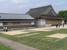
The ruins of Sasayama Castle overlook the city, represent its symbol and most important sight. The Sasayama Historical Museum was built in a new wooden structure on the typical stone base.
Other attractions include the ruins of Yakami Castle and the historic village of Aoyama.
The Dekanshon Matsuri takes place in August each year .
traffic
Five train stations on the JR Fukuchiyama Line are on the western edge of the city:
- Kusano
- Furuichi
- Minami-Yashiro
- Sasayamaguchi
- Tamba-Oyama
With the ramp Tannan-Sasayama Sasayama is connected to the Maizuru-Wakasa-Autobahn of the Japanese motorway network.
sons and daughters of the town
Town twinning
Neighboring cities and communities
- Hyogo Prefecture
- Kyoto Prefecture
- Osaka prefecture
Web links
Individual evidence
- ↑ Kokudo chiri kyōkai ( 国土 地理 協会 , English "Japan Geographic Data Center"): 市町村 変 更 情報 [set the search mask to a suitable interval], accessed on May 2, 2019.
- ↑ 「丹波 篠 山 市 へ 変 更」 賛成 多数 注目 の 投票 率 、 5 割 超 す . In: Asahi Shimbun Digital. November 18, 2018. Retrieved December 27, 2018 (Japanese).


