
Neuenkirchen (Lueneburg Heath)
| coat of arms | Germany map | |
|---|---|---|
.jpg)
|
Coordinates: 53 ° 2 ' N , 9 ° 42' E |
|
| Basic data | ||
| State : | Lower Saxony | |
| County : | Heidekreis | |
| Height : | 69 m above sea level NHN | |
| Area : | 96.7 km 2 | |
| Residents: | 5634 (Dec. 31, 2019) | |
| Population density : | 58 inhabitants per km 2 | |
| Postal code : | 29643 | |
| Area code : | 05195 | |
| License plate : | HK | |
| Community key : | 03 3 58 017 | |
| Address of the municipal administration: |
Hauptstrasse 1/3 29643 Neuenkirchen |
|
| Website : | ||
| Mayor : | Carlos Brunkhorst ( CDU ) | |
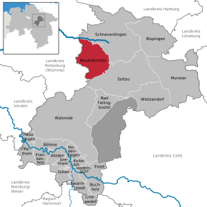
| Location of the community of Neuenkirchen in the Heidekreis district | ||
  |
||

_-_Hauptstra%C3%9Fe_-_Rathaus_01_ies.jpg)
_-_Hauptstra%C3%9Fe_-_St_Bartholom%C3%A4us_ex_01_ies.jpg)

_-_Sch%C3%A4ferhof_31_ies.jpg)
Neuenkirchen is a municipality in the district of Heidekreis , Lower Saxony . It is located on the western edge of the Lüneburg Heath on federal highway 71 between Rotenburg (Wümme) and Soltau . Neuenkirchen is a recognized health resort .
geography
Geographical location
Neuenkirchen is located in a forest, heather and moor landscape in the Lüneburg Heath, more precisely in the Walsroder Lehmgeest (natural area 64104), large parts of which are under landscape protection, including the Stichter See . The Neuenkirchen terminal moraine , which is cut by the Hahnenbach on the northern edge of Neuenkirchen, runs in a southwest-northeast direction .
Community structure
Ten localities belong to the municipality of Neuenkirchen. Population figures (as of December 15, 2014):
- Behningen 76
- Brochdorf 294
- Delmsen 733
- Gilmerdingen 213
- Horror 334
- Holland 189
- Neuenkirchen 2,661
- Swallows 363
- District 320
- Tewel 586
Total 5769
(Source: Heidekreis local transport plan 2015–2019, based on the Lower Saxony State Office for Statistics)
history
Neuenkirchen developed from the earlier Kerkspel Nyenkerken , as it was first mentioned in a document. This also included some older villages such as Delmsen, Tewel, Grauen, Ilhorn, Sprengel and Behningen.
The following founding legend exists for Neuenkirchen: Once they wanted to build a church and chose a location in Delmsen that seemed suitable. But the church under construction burned down three times, so people thought the devil lived there. However, since they could not agree on a suitable place, it was decided to harness a horse to a wagon and load the church bell onto the wagon. So that the horse did not go back to its stable, but simply ran around randomly, its eyes were blindfolded. The horse started running and stopped right in the Hahnenbach. Since the church couldn't be built in it, the people drove the horse on until it stopped on a beautiful green meadow in the middle of the village. The church that still stands today was built there without incident, and Neuenkirchen was given not only a name but also a coat of arms that reflects this history.
In the Middle Ages the place was a so-called free spell ; this meant that the mostly free peasantry in Neuenkirchen exercised the jurisdiction itself.
After 1945 Neuenkirchen experienced strong growth through refugees and displaced persons from formerly German eastern regions, Czechoslovakia and Bessarabia .
On March 1, 1974, as part of the administrative and territorial reform, the former independent communities Behningen, Brochdorf, Delmsen, Gilmerdingen, Grauen, Ilhorn, Schwalingen, Sprengel and Tewel were incorporated into the community of Neuenkirchen.
In 1986, the television show Dalli Dalli was broadcast live near the Neuenkirchen train station . Over 3000 people were there that day. A special train was used on the Soltau (Han.) - Neuenkirchen railway line for the television broadcast.
The Potato Festival in Neuenkirchen has existed since 1992, usually on the third Saturday in September.
On the morning of October 20, 2004, an earthquake shook the community. It had its epicenter near Neuenkirchen and reached a strength of 4.5 on the Richter scale .
politics
Municipal council
The municipal council consists of 17 members. The mayor is an ex officio member. Since the local elections in 2016, the distribution of seats is as follows:
mayor
Carlos Brunkhorst, a member of the CDU, has been mayor since May 20, 2010.
Culture and sights
- Neuenkirchen natural swimming pool
- Schäferhof in Neuenkirchen
- Sprengeler mill in Sprengel
- Neuenkirchener Draisinenbahn in Neuenkirchen
- The Schroershof in Neuenkirchen
- Springhornhof Art Foundation in Neuenkirchen
- Heide adventure trail on the B 71 near Neuenkirchen
- Tödters rock garden in Neuenkirchen
- St. Bartholomew Church
Economy and Infrastructure
Companies
There are two industrial areas in the community : The Siemensstraße area on Landesstraße 171 in the direction of Visselhövede and the Robert-Koch-Straße area on Bundesstraße 71 in the direction of Rotenburg.
traffic
Street
Neuenkirchen is on federal highway 71 . There is also the K 17 (- K 139 - B 440 - K 164) in the direction of Bad Fallingbostel and the state road 171 from Schneverdingen to Verden (Aller) .
railroad
The previously existing Soltau – Neuenkirchen railway line operated by the OHE has since been partially dismantled. On the rest of the route in Neuenkirchen there has been a trolley track since January 1, 2014, and was officially opened on May 3, 2014.
Transportation
Local public transport (ÖPNV) is handled by bus lines 200 (Soltau - Neuenkirchen), 105 (Schneverdingen - Neuenkirchen), the ring line 205 (Neuenkirchen - Tewel - Sprengel - Neunkirchen) and the citizen bus line 881 (Visselhövede - Neuenkirchen).
Personalities
- Hawoli (* 1935, actually Hans-Wolfgang Lingemann ), painter and sculptor.
Web links
- Network Schwalingen: The Heidedorf Schwalingen and what you should know about it.
- gemeinde-neuenkirchen.de
Individual evidence
- ↑ State Office for Statistics Lower Saxony, LSN-Online regional database, Table 12411: Update of the population, as of December 31, 2019 ( help ).
- ^ Federal Statistical Office (ed.): Historical municipality directory for the Federal Republic of Germany. Name, border and key number changes in municipalities, counties and administrative districts from May 27, 1970 to December 31, 1982 . W. Kohlhammer GmbH, Stuttgart / Mainz 1983, ISBN 3-17-003263-1 , p. 235 .
- ↑ http://www.bgr.bund.de/DE/Themen/Erdbeben-Gefaehrdungsanalysen/Seismologie/Seismologie/Erdbebenauswert/Besondere_Erdbeben/Ausgewaehlte_Erdbeben/rotenburg.html
- ↑ mps public solutions gmbh: Neuenkirchen community - home page. Retrieved April 12, 2017 .
- ↑ http://www.gemeinde-neuenkirchen.de/staticsite/staticsite.php?menuid=58&topmenu=2&keepmenu=inactive
- ↑ Super user: Heideerlebnispfad. Accessed October 1, 2017 (German).
- ↑ Super user: Heideerlebnispfad. Accessed October 1, 2017 (German).
Ahlden (Aller) | Bad Fallingbostel | Bispingen | Böhme | Buchholz (Aller) | Eickeloh | Essel | Frankenfeld | Gilten | Grethem | Hademstorf | Häuslingen | Hodenhagen | Lindwedel | Munster | Neuenkirchen | Rethem (Aller) | Schneverdingen | Schwarmstedt | Soltau | Walsrode | Wietzendorf
Non- parish district in the district of Heidekreis
Osterheide