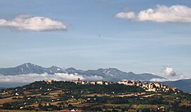
Treia (brands)
| Treia | ||
|---|---|---|

|
|
|
| Country | Italy | |
| region | Brands | |
| province | Macerata (MC) | |
| Coordinates | 43 ° 19 ′ N , 13 ° 19 ′ E | |
| height | 342 m slm | |
| surface | 93.07 km² | |
| Residents | 9,204 (Dec. 31, 2019) | |
| Population density | 99 inhabitants / km² | |
| Post Code | 62010 | |
| prefix | 0733 | |
| ISTAT number | 043054 | |
| Popular name | Treiesi | |
| Patron saint | Patrick of Ireland (March 17th) | |
| Website | Treia | |

|
||
Treia is an Italian commune with 9,204 inhabitants (as of December 31, 2019) in the province of Macerata in the Marche region .
location
Treia is located about 11 kilometers west-northwest of Macerata north of the Potenzatal and is part of the Comunità montana Alte Valli del Potenza e Esino . The municipality is also a member of the I borghi più belli d'Italia association (The Most Beautiful Places in Italy).
history
Until 1790 the name of the place was Montecchio . Pope Pius VI elevated the place to a city (Città) and gave it the historical name Treia of the ancient predecessor settlement .
After Italy entered the war in June 1940, the fascist regime set up an internment camp ( campo di concentramento ) in Treia . The camp was located in Villa Spada , also known as Villa La Quiete , in the Passo di Treia district .
It was a women's camp; Apart from Polish and Russian women , the internees were mainly French and English ; from 1942 Yugoslav women were added. On August 1, 1940, the camp had 37 inmates, 15 of whom were Jewish.
The country house had many shortcomings; z. B. there was only a cold water bath and a washbasin for over 40 women; the roof was leaking. Through the Swiss legation in Rome, the International Committee of the Red Cross (ICRC) and the British Foreign Office intervened several times with the Italian authorities in order to improve the conditions of internment. However, since the owner refused to cover the repair and renovation costs, the internees were relocated to Petriolo in December 1942 .
traffic
Strada Statale 361 Septempedana runs south of the town of Treia, but still within the municipal boundaries .
Sons and daughters of the church
- Luigi Lanzi (1732–1810), Jesuit and archaeologist
- Francesco Ansaldo Teloni (1760–1846), Catholic clergyman, Bishop of Macerata and Tolentino
Web links
Individual evidence
- ↑ Statistiche demografiche ISTAT. Monthly population statistics of the Istituto Nazionale di Statistica , as of December 31 of 2019.
- ^ I borghi più belli d'Italia. Borghipiubelliditalia.it, accessed August 12, 2017 (Italian).
- ↑ Carlo Spartaco Capogreco, I Campi del duce. L'internamento civile nell'Italia fascista (1940-1943) , Torino 2004 (Einaudi), pp. 193-194; Klaus Voigt, Refuge on Revocation. Exil in Italien 1933-1945 , Volume 2, Stuttgart 1993 (Klett-Cotta), pp. 61-65

