Milseburger Kuppenrhön
| Milseburger Kuppenrhön | ||
|---|---|---|
| location | District of Fulda , Hesse | |
| Western part of the | Kuppenrhön , Rhön | |
|
|
||
| Coordinates | 50 ° 31 ' N , 9 ° 53' E | |
| surface | 307.2 km² | |
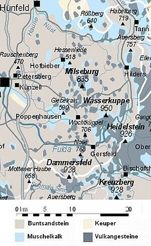
The Milseburger Kuppenrhön (also: Westliche Kuppenrhön ) , located almost entirely in the district of Fulda , Hesse , is the central western natural area of the Rhön , which surrounds the 950 m high Wasserkuppenrhön from the west. With the eponymous, 835 m high Milseburg , it bears by far the highest elevation of the Kuppenrhön .
Location and limits
The Milseburger Kuppenrhön extends to the north to the Nüsttal below Obernüst , to the east it is roughly extended by the state road to ( Habel -) Esbachsgraben . Behind this line is the Soisberger Kuppenrhön , which is up to 719 m high .
In the north east it joins the (Middle) Ulstertal , behind which the up to 757 m high Auersberger Kuppenrhön connects, in the middle east it lies along a contour line at around 650 m around the Wasserkuppenrhön with the 950 m high Wasserkuppe .
From southeast to south it flanks the Dammersfeld ridge around the 928 m high Dammersfeldkuppe between Gersfeld and Motten . To the north of Motten, in the extreme southwest, lies the only Bavarian ( Bad Kissingen district ) elevation in the natural area, the Hohe Kammer ( 700 m ) covering the Dammersfeld , the Döllau der Große Haube ( Mottener Haube , 658 m ) in the north of the Döllbach overflow Brückenauer Kuppenrhön faces.
To the west the landscape flattens just east of the line Thalau - Weyhers - Friesenhausen - Hofbieber - Rimmels ( rejection Weyhers-Schmalnau-Altenhof ) to rarely above 500 m reach Western Rhön foreland from where the border in the north to the lower reaches of the wetness follows.
In the above The Milseburger Kuppenrhön is 27 km long in north-north-east-south-south-west direction and only 4–12 km wide. It covers 297.04 km² in Hesse and another 10.16 km² in Bavaria on the Hohen Kammer.
Different demarcation
The State Ministry's environmental atlas of Hessen places the northern border much more northerly, which, however, does not appear geologically (see adjacent map) or orographically conclusive - see Soisberger Kuppenrhön # other boundary drawing .
Landscape and geology
In the Milseburger Kuppenrhön there is red sandstone almost everywhere outside the summit , which means that the Fulda and its tributaries have deepened by 200-300 m. From these valleys rise moderately steep pedestals, on which the individual basalt peaks sit on.
The fact that the Milseburg at 835 m clearly exceeds the mountain heights in other parts of the Kuppenrhön (maximum 757 m ) should not hide the fact that only a few mountains in the natural area reach a height of more than 700 m . Usually the heights of the (higher) crests are around 650 m .
Rivers
Almost the entire landscape drains via (from north to south) Nüst , Nässe , Bieber , Wanne , Lütter , Fulda and Schmalnau to the west to the Fulda - the northern half via the detour of the Haune . The Rhine-Weser watershed in the south and the south of the watershed between Fulda and Werra in the south-east lie outside, in different parts of the Hohe Rhön . In the north-east, in turn, the Fulda-Werra watershed flanks the Ulster at a distance of only one and a half kilometers and at the same time forms its edge heights. Only a small circle about 7.5 kilometers in diameter between Wasserkuppe, Milseburg and the course of the Ulster around the town of Hilders drains via Scheppenbach and Brandbach to Ulster and thus into the Werra system.
North half
In the north, the Nüst , in the northwest to the wet , is initially followed by a rather flat undulating hill country . Heights of 650 m are only reached further southeast of various knolls on and just northwest of the Fulda-Werra watershed, which leaves its proximity to Ulster at the Eckweisbacher knoll ( 642 m ) and turns in a quarter arc to the Hohlstein ( 685 m ) immediately north the Milseburg and its northern foothills moved to the southwest.
The Phonolite of the Milseburg ( 835 m ) is the first summit that exceeds 700 m . Between it and the already water Kuppenrhön introductory Weiherberg ( 786 m ) it brings the boys Bader stone still so much: ( 759 m ), but remains at just 1.2 kilometers dominance and prominence of 50 meters more or less a Randa height of 76 m higher natural area named after it.
More prominent is the Stellberg ( 727 m , also phonolite) to the southwest, southwest of the main mountain, which is separated from the Milseburg by the 200 m deeper valley of the Bieber . To the south-east of this, considerable heights are also reached on the Maulkuppe ( 706 m ) and, beyond the Wanne spring, on the Teufelstein ( 729 m ).
East of the Milseburg and north of the Wasserkuppenrhön, finally, a ridge starting from Weiherberg, which reaches 669 m on the Tannenfels, extends between Scheppenbach and Brandbach right up to Ulster.
Southern half
The area from the valley of the Wanne to both sides of the Lütter valley around Poppenhausen is again more of a depression landscape, within which the Giebelrain ( 588 m ) at the western threshold to the foreland between the two rivers already has the character of a bolt.
Wachtküppel ( 706 m , east - basalt) and Ebersberg ( 689 m , west - phonolite), and between Fulda and Schmalnau Große ( 768 m - basalt) and Kleine Nalle ( 704 m , south - phonolite) are striking between Lütter and Fulda .
In contrast, all the elevations of the natural area south of the Schmalnau are at the edge of the Dammersfeld ridge , which is up to 928 m high and which already has hardly any basalt left. As such, the rock sandstone ridge of the 700 m high Hohen Kammer - the only elevation on Bavarian ground - closes off the natural area to the southwest and the slope of the Dammersfeld ridge to the west.
mountains
-
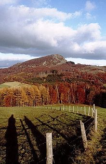
Milseburg ( 835 m , central southeast of Kleinsassen ) - popular panoramic mountain, watershed
- Bubenbader Stein ( 759 m , southeast of Milseburg) - watershed
- Oberbernhardser Höhe ( 661 m , northern foothills to the Hohlstein group near Oberbernhards ) - watershed
-
Große Nalle ( 768 m , southwest of Gersfeld ) - between Fulda (N) and Schmalnau (S)
- Kleine Nalle ( 704 m , south of the Große Nalle)
-
( Weiherberg ( 786 m , Wasserkuppenrhön !) - watershed)
- Teufelstein ( 729 m , western foothills)
- Schwarzenhauck ( 663 m , southwest foothills)
- Stellberg ( 727 m , east of Wolferts ) - between Bieber and Wanne
- Wachtküppel ( 706 m , northwest of Gersfeld) - between Lütter (N) and Fulda (S)
-
( Dreifeldskuppe ( 832 m , Dammersfeld ridge ))
- Hohe Kammer ( 700 m , northwest foothills north of Motten ) - the only Bavarian mountain in the natural area in the extreme southwest, south of the Schmalnau
-
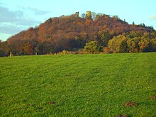
Ebersberg ( 689 m , AT) - between Lütter and Fulda, castle ruins, AT
- Heidküppel ( 601 m , southwest) - transmitter
- Hohlstein Group (up to 685 m , north between Bieber and Nüst , on and northwest of the watershed)
-
Hohlstein ( 685 m , north of Milseburg and Oberbernhards, southwest of the group)
- Schackenberg ( 557 m , west of Hohlstein and east of Schackau )
- Bomberg ( 670 m , central) - watershed
- Schweinsberg ( 655 m , north)
-
Großer Grubenhauck ( 643 m , north)
- Kleiner Grubenhauck ( 641 m , west of the Great)
-
Hohlstein ( 685 m , north of Milseburg and Oberbernhards, southwest of the group)
-
Tannenfels (Rhön) ( 669 m , west of Wickers in the northeast draining to Ulster ) - between Scheppenbach (NW) and Brandbach (SO); Castle ruins
- Findlos Berg ( 635 m , northeast)
-
Eckweisbacher Kuppe ( 642 m , extreme northeast west of Wickers ') - watershed
- Bernhardser Kuppe ( 571 m , north) - watershed
- Giebelrain ( 588 m , western interface to the western foreland east of ( Künzell -) Dietershausen ) - between Wanne (N) and Lütter (S)
Individual evidence
- ↑ Natural spaces in the district of Kissingen - PDF, 89 kB; the small part in the northeast, marked 353.21, is the Hohe Kammer
-
↑ a b Various authors: Geographical Land Survey: The natural spatial units in single sheets (per map 1: 200,000 and paperback) - Federal Institute for Regional Studies, Bad Godesberg 1959–1987:
- Page 126: Fulda (W. Röll 1969) - not yet included!
- Sheet 140: Schweinfurt (Brigitte Schwenzer 1968)
- ↑ Map and legend of the natural areas of Hesse (online copy of Die Naturraum Hessens , Otto Klausing 1988) in the Hessen Environmental Atlas of the Hessian State Office for Environment and Geology
- ↑ Natural areas of the main unit groups 23, 14 and 35 in the Bavaria Atlas of the Bavarian State Government - Rhine-Main-Tiefland , Odenwald, Spessart, Südrhön and Rhön ( notes )
- ↑ Map and description in the Hesse Environmental Atlas (open in new window! )
- ^ E. Meynen and J. Schmithüsen : Handbook of the natural spatial structure of Germany - Federal Institute for Regional Studies; 4th / 5th Delivery Remagen 1957, 6th delivery Remagen 1959, updated map 1: 1,000,000 with main units 1960


