Wilmsdorf (Bannewitz)
|
Wilmsdorf
Municipality Bannewitz
Coordinates: 50 ° 58 ′ 3 ″ N , 13 ° 42 ′ 46 ″ E
|
|
|---|---|
| Height : | 293–313 m above sea level NN |
| Area : | 2.73 km² |
| Residents : | 897 (Dec. 31, 2012) |
| Population density : | 329 inhabitants / km² |
| Incorporation : | April 1, 1938 |
| Incorporated into: | Possendorf |
| Postal code : | 01728 |
| Area code : | 0351 |
|
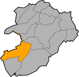
Location of Wilmsdorf in Bannewitz
|
|

Wilmsdorf is a district of the Saxon community of Bannewitz in the district of Saxon Switzerland-Eastern Ore Mountains .
geography
The Waldhufendorf is located south of the main town on the Poisenbach . State road 36 and district road 9015 meet in the village. Federal road 170 also runs through Wilmsdorf on the border with Hänichen . The village of Hänichen borders Wilmsdorf in the northeast, the village Welschhufe in the north, Obernaundorf (zu Rabenau ) in the west, Börnchen in the southwest and Possendorf in the east .
history
Although the place is first mentioned in a document in 1440, it probably originated at the end of the 12th or beginning of the 13th century. In 1551 the place belonged to Rabenau Castle , from 1565 to the Berreuth manor , 1569 to the Dippoldiswalde office and in 1875 to the Dippoldiswalde office . From 1876 to 1939 the village had its own school. In 1938 Wilmsdorf was incorporated into Possendorf and in 1999 to the district of Bannewitz.
Good
The freehold was mentioned in 1776 under the owner Johann George Schill first time that it from its predecessor, Christiane Friederika Henrietta Staubitz , through his Lehnträger bought Mr. Albrecht. In 1777 he sold on to the court commissioner Nicolaus Victor Mühlberger, although Schill did not leave the estate until 1780. In the same year the manor owner von Possendorf bought it ; it received the written address . It was about a 1 7 / 8 hooves (30 ha) property where the January 6, 1776 Ferdinand Baptista von Schill was born. Between the upper Poisen houses and the Vorwerk there was a brick factory belonging to the estate at the Poisenwald . In 1863 Carl Friedrich August Dathe von Burgk bought the estate. Today only the mansion remains . The complex serves the Dresden-Elbflorenz Golf Club.
Coal shafts
In 1853 the Berglustschacht was created in the northeast of the village. On April 1, 1857, the first coal train ran on the newly built route ( Windbergbahn ) in the direction of Dresden, which ended at kilometer 12.478 directly at the shaft . In 1905 mining was stopped there. In 1906 the demolition of the driver's house began, which was followed by the other buildings. The God's blessing shaft in the west of the village on the Poisenwald was built by Georg Ed. Schmidt, Wilhelm August Schmidt and Wilhelm Friedrich Freudenberg laid out in 1854. In 1856 the shaft reached a depth of 168 meters without encountering a mining seam .
traffic
The royal Saxon state road from Dresden to Teplitz was built between 1842 and 1846. The former level crossing and the bus stop at Käferberg are to be regarded as the boundary of the district. Around 1939 it was renamed Reichsstrasse 170 , later designated as trunk road 170 and finally as federal road 170 in 1990. Today the three-lane downhill section between Hänichen and Possendorf runs along the Käferberg.
Historic paths are the Marktsteig , which comes from Rabenau via Obernaundorf and the Poisenwald, through Wilmsdorf, Welschhufe and Gittersee to Dresden . The Kleine Straße from Freiberg via Höckendorf , Seifersdorf , Oelsa runs through Wilmsdorf, Possendorf, Rippien to Dresden.
The old route of the Windbergbahn runs over a length of around 600 meters through the local area and is now used as a bicycle and footpath. On September 30, 1908, the first train ran on the newly built line that re-used the route of the coal railway to the Berglustschacht and Hermannschacht between the Hänichen-Goldene Höhe station and Possendorf . The last train ran on November 9, 1957, and the line was dismantled.
Personalities
- Ferdinand von Schill (1776–1809), Prussian officer and free corps leader
Others
- Mayor is Lutz Noack.
Web links
- Wilmsdorf in the Digital Historical Directory of Saxony
- Wilmsdorf at www.bannewitz.de
Individual evidence
- ↑ Municipal administration Bannewitz: Presentation of the districts of Bannewitz
- ^ Michael Rademacher: German administrative history from the unification of the empire in 1871 to the reunification in 1990. Dippoldiswalde district. (Online material for the dissertation, Osnabrück 2006).

