Vyazemsky
| city
Vyazemsky
Вяземский
|
||||||||||||||||||||||||||||||||||||
|
||||||||||||||||||||||||||||||||||||
|
||||||||||||||||||||||||||||||||||||
| List of cities in Russia | ||||||||||||||||||||||||||||||||||||
Vyazemski ( Russian Вя́земский ) is a city in the Khabarovsk region ( Russia ) with 14,555 inhabitants (as of October 14, 2010).
geography
The city is located in the Ussuri lowlands, about 120 km south of the regional capital, Khabarovsk , a few kilometers east of the Ussuri near the Chinese border.
The city of Vyazemsky is the administrative center of the raion of the same name .
history
Vyazemsky was built in 1894 in connection with the construction of the Ussuri Railway from Khabarovsk to Vladivostok, which opened in 1897 and later became part of the Trans-Siberian Railway. The place and station were named after the construction manager of the line, engineer Orest Vyazemsky. In 1938 the place received the status of an urban-type settlement and in 1951 city rights.
Population development
| year | Residents |
|---|---|
| 1939 | 11,902 |
| 1959 | 17,957 |
| 1970 | 18,365 |
| 1979 | 18,919 |
| 1989 | 18,426 |
| 2002 | 15,760 |
| 2010 | 14,555 |
Note: census data
Culture and sights
There is a small local museum in Vyazemsky.
Economy and Infrastructure
The city's economy is determined by companies in the wood processing, food and building materials industries as well as rail transport.
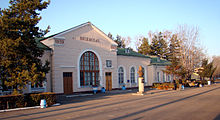
Vyazemsky has a station on the Trans-Siberian Railway (station name Vyazemskaya , route kilometer 8651 from Moscow ). Local trains ( Elektritschkas ) run from Khabarovsk to this point. The city is also on the M60 “Ussuri” Khabarovsk- Vladivostok highway .
Web links
- Vyazemsky on the website of the administration of the Khabarovsk region (in Russian)
- Vyazemsky on mojgorod.ru (Russian)
Individual evidence
- ↑ a b Itogi Vserossijskoj perepisi naselenija 2010 goda. Tom 1. Čislennostʹ i razmeščenie naselenija (Results of the All-Russian Census 2010. Volume 1. Number and distribution of the population). Tables 5 , pp. 12-209; 11 , pp. 312–979 (download from the website of the Federal Service for State Statistics of the Russian Federation)


