Zedtwitz (Feilitzsch)
|
Zedtwitz
community Feilitzsch
Coordinates: 50 ° 21 ′ 42 " N , 11 ° 54 ′ 15" E
|
||
|---|---|---|
| Height : | 510 m above sea level NN | |
| Residents : | 881 | |
| Incorporation : | May 1, 1978 | |
| Postal code : | 95183 | |
| Area code : | 09281 | |
|
Location of Zedtwitz in Bavaria |
||

Zedtwitz is a district of the municipality Feilitzsch in the Upper Franconian district of Hof in Bavaria .
geography
Geographical location and traffic
Zedtwitz is located west of the main town of Feilitzsch in a convenient location on the HO 14 road and south-east of the "Hof / Töpen " junction , where Autobahn 72 and Bundesstraße 2 intersect. The latter leads past Zedtwitz to the west, the Leipzig – Hof railway line touches the corridor to the east. Just south joins with the district Unterkotzau an administrative district court on. The Rohrbach, which flows past Zedtwitz in the east, drains into the Saxon Saale .
Zedtwitz is located in a low mountain range between the Thuringian Slate Mountains , the Mittelvogtland hilltop land , the Franconian Forest and the Fichtel Mountains . The language border between the Thuringian and Saxon Vogtland and the Bavarian Vogtland is also at this point .
Neighboring places
| Moosanger | Schafhübel | |
| Forest |

|
Feilitzsch |
| Unterkotzau |
history
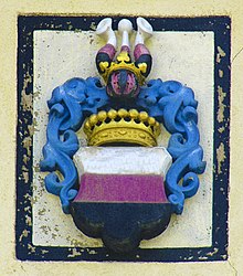
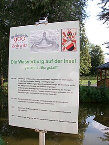
The place Zedtwitz is the ancestral home of the von Zedtwitz family . The Zedtwitzer family was first mentioned in a document in 1235 with the knight Georg von Zedtwitz. From the 13th to the 16th century, the Zedtwitzer ruled the Zedtwitz estate in the knightly canton of Gebürg . This included the well-fortified Zedtwitz moated castle , now a castle stable , which was preceded by the Munichreuth Vorwerke with 16 estates (1502) and knight seats in Isaar (1412) and Töpen . In 1502 the castle in Zedtwitz passed from the Zedtwitz to the neighboring and related noble family von Feilitzsch , who were followed by the von Ende family (1577 to 1638) as another noble owner . It then belonged to the margrave Colonel Peter Reuschel and the secret councilor Erdmann von Stein (1717). He had the farm buildings and the spacious baroque palace built parallel to the old trade route from Hof to Schleiz . The castle and the estate passed to the Lords of Plotho through the daughters of Baron von Stein . Erich Christoph von Plotho , Minister under the Prussian King Frederick the Great , died on the property of his wife in Zedtwitz. Opposite the castle, which is now used as a residential and nursing home, is the castle stables of the Zedtwitz moated castle , the remains of which were removed in 1839. The Zedtwitz estate passed into bourgeois hands in 1852.
Zedtwitz belonged with the Regnitzland between the 12th and 14th centuries to the administrative area of the Vögte von Weida , which is why the name Bayerisches Vogtland is used for this area today . In 1373 they sold their claims to the Burgraviate of Nuremberg , from whose Upper Mountain portion the Principality of Bayreuth later developed. From 1498 Zedtwitz belonged to his "military district Hof", from which the provincial governorate Hof had developed in the first half of the 16th century . With the Principality of Bayreuth, Zedtwitz fell to the Kingdom of Prussia in 1792 , then to France and in 1810 to the Kingdom of Bavaria . Zedtwitz assigned this to the Mainkreis , which was referred to as Obermainkreis from 1817 and as Upper Franconia from 1838 . Zedtwitz has belonged to the Free State of Bavaria since 1918 and to the Hof district since 1939.
Due to the division of Germany after 1945, Zedtwitz was on the edge of the GDR zone . Because the Rudolphstein bridge on the Munich-Berlin autobahn was blown up in 1945, today's A 72 autobahn was used as an interzonal crossing between 1945 and 1951, but the crossing was shut down in 1951 and traffic was over the Bundesstraße 2 - Töpen-Juchhöh border crossing until the Saale valley viaduct was rebuilt in 1966 - directed, which was north of Zedtwitz. From 1951 to 1989, the autobahn over the inner German border between Hof / Töpen north of Zedtwitz and Pirk was closed to traffic. The section located in Bavaria was known as Bundesautobahn 722 ( BAB 722 ) or Autobahn 722 ( A 722 ) before German reunification . After 1990, through the turning point and peaceful revolution in the GDR , the gap on the federal motorway 72 between Bavaria and Saxony was closed.
Until the introduction of the Reformation in 1529, Zedtwitz owned a chapel, the location of which can no longer be located today. On July 20, 1958, the Friedenskirche was consecrated. It was built in the castle park next to Zedtwitz Castle. On May 1, 1978, Zedtwitz was incorporated into the Feilitzsch community. The local school was closed a year earlier.
literature
- Johann Kaspar Bundschuh : Zedtwitz, Zettwitz, Zedwitz . In: Geographical Statistical-Topographical Lexicon of Franconia . tape 6 : V-Z . Verlag der Stettinische Buchhandlung, Ulm 1804, DNB 790364328 , OCLC 833753116 , Sp. 526 ( digitized version ).
- Johann Kaspar Bundschuh : Zedtwitz . In: Geographical Statistical-Topographical Lexicon of Franconia . tape 6 : V-Z . Verlag der Stettinische Buchhandlung, Ulm 1804, DNB 790364328 , OCLC 833753116 , Sp. 971 ( digitized version ).
- August Gebeßler : City and District of Hof . The Art Monuments of Bavaria , Brief Inventories , Volume VII . German art publisher . Munich 1960. p. 66f.
- Pleikard Joseph Stumpf : Zedtwitz . In: Bavaria: a geographical-statistical-historical handbook of the kingdom; for the Bavarian people . Second part. Munich 1853, p. 595 ( digitized version ).
Web links
Individual evidence
- ^ Officials of the municipality of Feilitzsch.Retrieved on November 20, 2012.
- ^ Federal Statistical Office (ed.): Historical municipality directory for the Federal Republic of Germany. Name, border and key number changes in municipalities, counties and administrative districts from May 27, 1970 to December 31, 1982 . W. Kohlhammer GmbH, Stuttgart / Mainz 1983, ISBN 3-17-003263-1 , p. 688 .


