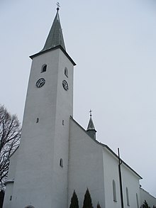
Zubrohlava
| Zubrohlava | ||
|---|---|---|
| coat of arms | map | |

|
|
|
| Basic data | ||
| State : | Slovakia | |
| Kraj : | Žilinský kraj | |
| Okres : | Námestovo | |
| Region : | Orava | |
| Area : | 15.256 km² | |
| Residents : | 2,359 (Dec 31, 2019) | |
| Population density : | 155 inhabitants per km² | |
| Height : | 630 m nm | |
| Postal code : | 029 43 | |
| Telephone code : | 0 43 | |
| Geographic location : | 49 ° 27 ' N , 19 ° 31' E | |
| License plate : | NO | |
| Kód obce : | 510246 | |
| structure | ||
| Community type : | local community | |
| Administration (as of November 2018) | ||
| Mayor : | Pavol Bugeľ | |
| Address: | Obecný úrad Zubrohlava Plátennícka 464 029 43 Zubrohlava |
|
| Website: | www.zubrohlava.eu | |
| Statistics information on statistics.sk | ||
Zubrohlava (Hungarian Bölényfő ) is a municipality in northern Slovakia with 2359 inhabitants (as of December 31, 2019) and is located in Okres Námestovo , a district of the Žilinský kraj .
geography
The municipality is located in the hill country Podbeskydská vrchovina in the traditional Orava (German Arwa ) landscape not far from the Polish border on the Polhoranka brook , which flows into the Orava reservoir not far from the municipality . The center of the village, at an altitude of 620 m nm , is located five kilometers northeast of Námestovo .
history
The place is mentioned for the first time on a map from 1550; there he is mentioned as Zbracslaua . In 1958 the place was badly affected by a flood.
Loosely translated, the place name means "bison head".
population
Results after the 2001 census (1968 inhabitants):
|
By ethnicity:
|
By religion:
|

