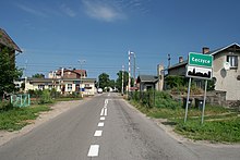
Łęczyce (Powiat Wejherowski)
| Łęczyce | ||
|---|---|---|

|
|
|
| Basic data | ||
| State : | Poland | |
| Voivodeship : | Pomerania | |
| Powiat : | Wejherowski | |
| Gmina : | Łęczyce | |
| Geographic location : | 54 ° 35 ' N , 17 ° 52' E | |
| Residents : | 1524 | |
| Postal code : | 84-218 | |
| Telephone code : | (+48) 58 | |
| License plate : | GWE | |
| Economy and Transport | ||
| Street : | DK 6 : Szczecin - Danzig | |
| Rail route : | PKP - route 202: Danzig – Stargard | |
| Next international airport : | Danzig | |
Łęczyce [wɛnˈt͡ʂɨt͡sɛ] ( German Lanz, Kreis Lauenburg / Pommern , Kashubian Łãczëce ) is a village in the powiat Wejherowski in the Polish voivodeship of Pomerania . It is the seat of the rural community of the same name .
Geographical location
The village is located in Western Pomerania , in the valley of the Łeba (Leba) , which flows through the center, about 14 kilometers northeast of Lębork (Lauenburg in Pomerania) and 27 kilometers west of Wejherowo (Neustadt in West Prussia) .
The Polish state road 6 (former German Reichsstrasse 2 , today also European route 28 ) runs three kilometers south of the village and runs from Stettin to Danzig and on to Pruszcz Gdański (Praust) .
The nearest train station is Godętowo (until 1945 Goddentow-Lanz ) on the state railway line 202 from Danzig to Stargard .
history
Around 1780 the village had a free school , which was entitled to keep a lock in Leba for catching salmon , eight farms, two Büdner and a schoolmaster and had 16 fireplaces (households).
Until 1945 Lanz was in the district of Lauenburg i. Pom. incorporated in the administrative district of Köslin of the Prussian province of Pomerania . It belonged to the municipalities of Bresin (today Brzeżno Lęborskie), Hohenfelde (Wysokie), Kattschow (Kaczkowo), Krahnsfelde (Chrzanowo) and Pusitz (Pużyce) to the administrative district of Schweslin (Świetlino) and to the district court area of Lauenburg in Pomerania .
Towards the end of the Second World War , the Red Army occupied the region in the spring of 1945 . Soon afterwards, Western Pomerania, along with West Prussia and the southern half of East Prussia, was placed under Polish administration by the Soviet Union . In Lanz the immigration of Polish civilians began. The German village of Lanz received the Polish place name Łęczyce . In the following period, the villagers were evicted .
In 1945 the village was incorporated into the Powiat Wejherowski (Powiat Neustadt in West Prussia ) within the Pomeranian Voivodeship ( Gdansk Voivodeship until 1998 ). It is part and seat of Gmina Łęczyce, within which it forms a Schulzenamt with the localities Godętowo (Goddentow) , Wielistowo (Felstow) and Węgornia (Aalbeck) . 1524 inhabitants live here today.
Population development
| year | Residents | Remarks |
|---|---|---|
| 1822 | 156 | |
| 1925 | 676 | including 645 Evangelicals and 30 Catholics |
| 1933 | 865 | |
| 1939 | 817 |
church
Lanz belonged from time immemorial to the parish of Bresin (now in Polish: Brzeżno Lęborskie), which was probably founded in 1437 by the Teutonic Order . With the Reformation the village became Lutheran , but Lanz did not have its own church. The parish of Bresin belonged to the parish of Lauenburg in Pomerania in the eastern district of the church province of Pomerania in the church of the Old Prussian Union .
Mostly Catholic residents have lived in Łęczyce since 1945 . It now has its own parish church, which is named Kościół św. Antoniego Padewskiego ( Anthony of Padua ) carries. The parish belongs to the Gniewino ( Gnewin ) deanery in the Pelplin diocese of the Catholic Church in Poland .
Protestant church members living here are integrated into the parish of the Kreuzkirche in Słupsk ( Stolp ) in the diocese of Pomerania-Greater Poland of the Evangelical-Augsburg Church in Poland . The church is located in Lębork ( Lauenburg in Pomerania ).
Sons and daughters of the place
- Horst Katzor (1918–1998), German engineer and from 1969 to 1984 Lord Mayor of Essen.
Gmina Łęczyce
The rural community (gmina wiejska) Łęczyce covers an area of 232.8 km². 12,000 people live here.
literature
- Ludwig Wilhelm Brüggemann Detailed description of the current state of the Königl. Prussian Duchy of Vor and Hinter Pomerania . Part II, Volume 2: Description of the court district of the Royal. State colleges in Cößlin belonging to the Eastern Pomeranian districts . Stettin 1784, p. 1050, paragraph (11) .
- Franz Schultz : History of the Lauenburg district in Pomerania. Lauenburg i. Pom. 1912, p. 386.
Web links
- Gunthard Stübs and Pomeranian Research Association: The community of Lanz in the former Lauenburg district in Pomerania (2011).
- Website of Gmina Łęczyce (Polish)
Individual evidence
- ↑ Ludwig Wilhelm Brüggemann : Detailed description of the current state of the Königl. Prussian Duchy of Vor and Hinter Pomerania . Part II, Volume 2: Description of the court district of the Royal. State colleges in Cößlin belonging to the Eastern Pomeranian districts . Stettin 1784, p. 1050, paragraph (11) .
- ^ Friedrich von Restorff : Topographical description of the province of Pomerania with a statistical overview . Berlin / Stettin 1827, p. 285
- ^ Gunthard Stübs and Pommersche Forschungsgemeinschaft: The community of Lanz in the former Lauenburg district in Pomerania (2011).
- ^ A b Michael Rademacher: German administrative history from the unification of the empire in 1871 to the reunification in 1990. lauenburg_p.html # ew39lauplanz. (Online material for the dissertation, Osnabrück 2006).

