Šarbov
| Šarbov | ||
|---|---|---|
| coat of arms | map | |

|
|
|
| Basic data | ||
| State : | Slovakia | |
| Kraj : | Prešovský kraj | |
| Okres : | Svidník | |
| Region : | Šariš | |
| Area : | 8.438 km² | |
| Residents : | 16 (Dec. 31, 2019) | |
| Population density : | 2 inhabitants per km² | |
| Height : | 446 m nm | |
| Postal code : | 090 04 ( Medvedie post office ) | |
| Telephone code : | 0 54 | |
| Geographic location : | 49 ° 26 ' N , 21 ° 38' E | |
| License plate : | SK | |
| Kód obce : | 527874 | |
| structure | ||
| Community type : | local community | |
| Administration (as of November 2018) | ||
| Mayor : | Stanislav Skasko | |
| Address: | 09005 Šarbov | |
| Statistics information on statistics.sk | ||
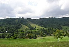
Šarbov ( Hungarian Sarbó ) is a municipality in the Svidník district in Slovakia . Šarbov lies at an altitude of 446 meters above sea level in the Prešovský kraj of eastern Slovakia .
The village lives from forestry and agriculture, especially from cattle breeding. The region around Šarbov is the Slovak-Polish border area and predominantly densely forested. Although the border is only a short distance east of Šarbov, the nearest official border crossing is about 17.5 kilometers by car to the east. The earliest written mention of Šarbov, then as Sarbowa , comes from 1618.
Web links
Commons : Šarbov - collection of images, videos and audio files

