
Aachener Strasse (Cologne)
The Aachenerstraße is with a length of 8726 meters (to the city limits) one of the longest arterial roads of Cologne and runs from the Hahnentorburg situated in the heart in the west and ends outside Cologne in Jülich .

history
Aachener Straße changed its street name frequently over time.
Neolithic and Roman times


At the current intersection of Aachener Strasse / Militärringstrasse (Cologne-Müngersdorf), a ceramic band settlement from the Neolithic Age (around 5500 BC ) was found from 1926 under the direction of Fritz Fremersdorf . There are clear traces of at least four large buildings with a large surrounding moat. Excavations here unearthed, among other things, a cut flint ax, a pointed ax made of silica slate and a shoe last wedge made of mica slate.
Today's Aachener Straße essentially follows the Roman road Via Belgica , which is an extension of the decumanus maximus via Jülich (Luliacum), Aachen (Aquae granni), Heerlen (Coriovallum), Maastricht (Mosa Trajectum) and Tongern (Atuatuca Tungrorum) to Boulogne-sur -Mer (Gesoriacum) led. In research, the name "Via Belgica" has established itself for the 62 km long section of road in Germany. At the height of Melaten, the paved Roman road reached a width of 6 meters. Milestones (such as the Sophienhöhe ) indicate that the Heerstraße was built in the 3rd and 4th centuries. At the Hahnentor north of Aachener Straße 5 pottery kilns were found, which date from the second half of the 3rd century and which also point to the Roman settlement of the area.
On all Cologne arterial roads (see Luxemburger Strasse or Neusser Strasse ), including Aachener Strasse, there were extensive necropolises that also occupied the area behind them. Excavations in April 1843 uncovered a well-filled burial chamber from Roman times (around 150 AD) on what is now the site at Aachener Strasse No. 1328 in Cologne-Weiden. In particular, it contained a sarcophagus made of white marble , three picture busts and two stone armchairs. At first it served only as a columbarium , later as a mausoleum . When the carter Ferdinand Sieger built an extension for his amusement ride here in 1843, he discovered a locking plate while digging rubble; this led to an underground burial chamber , which is one of the most important Roman graves north of the Alps today. In 1844, the then cathedral master builder Ernst Friedrich Zwirner acquired the burial chamber including the property on behalf of the Kingdom of Prussia . When the Jahnwiesen was expanded in 1926, a Roman manor ("Villa rustica") was found, which was built in the 1st century AD. Fremersdorf assumed that this manor was related to the Roman grave. Excavations at Hahnentor in 1929 showed that the width of Aachener Strasse, including the ditches, fluctuated between 24 and 26 meters.

middle Ages


From the early Middle Ages (440–640 AD) came a row grave field uncovered by Fritz Fremersdorf between 1927 and 1929 at the level of today's Müngersdorfer Stadium with 514 graves, which suggests a settlement of around 50 people.
Leper house and place of execution
One of four leprosories ("campus leprosi") that were outside the city walls because of the risk of infection was called "Maladen" (French "malade" = sick) and has been a donation "in campum leprosi" on Aachener Strasse since 1180. The complex consisted of seven hospitals, gardens and a cemetery. About 100 people with leprosy from all classes were taken in and burned after their death. It was examined by the sick, and it was only later that the Leprashau took over the medical faculty of the university . Archbishop Konrad von Hochstaden consecrated the chapel of St. Maria Magdalena and Lazarus on the largest of four Cologne infirmaries ; the chapel, which was rebuilt after its destruction in 1474, became the property of the city in 1804. In 1342 the name “vulgariter zuo den malaten” (house of the lepers) is found, when Johannes de Cervo gives the sick a mark of interest. The name "Malaten" alone appeared for the first time in 1364 as "hoysz zu Malayten". Since 1397 there has been a leprosy order for Melaten, in 1404 there is talk of the "hoef der seichen van Melaten".
From at least 1285 an area near Melaten, called Rabenstein, also served as a place of execution; Leprosy and execution site were often connected. On October 9, 1527, the robbery murderer Ludwig von Tetz (he committed at least 17 murders) was "wheeled" on Melaten, with his limbs being torn to pieces by the executioner with an iron wheel. On September 28, 1529, the Protestants Adolf Clarenbach and friend Peter Fliesteden were burned at the stake as heretics . The place of execution at Melaten was expanded in 1588 at the latest, when a roundabout for spectators was built next to the triangular gallows. On May 8th, 1593, reports Hermann von Weinsberg , the privateer Johann von Polheim was “untroubled and entertained” on the Rabenstein. The Cologne Schweidkarte by Abraham Hogenberg already shows two roundels in 1609. On May 19, 1627 , Katharina Henot (sister of Canon Hartger Henot ), who was accused of witchcraft , was burned at the stake in front of a large crowd in Melaten without a confession. After only one patient showed symptoms of leprosy in the leprosy house in 1712, the city closed the leprosy house in 1767. On July 13, 1797, the church robber Peter Eick was the last to be hanged on the gallows at the Melaten execution site, which was destroyed shortly afterwards during the French period in 1797 becomes.
Coronation Street and other street names
In the Middle Ages , the kings crowned in Aachen Cathedral drove via today's Aachener Straße to Cologne and were received by the archbishop at Hahnentor. At that time it was therefore called "Coronation Street". Thus Ferdinand I on January 5, 1531 in Cologne for the king chosen and by Archbishop Hermann of Wied anointed in Aachen and crowned. In Arnold Mercator's Cologne cityscape from 1570 , Aachener Strasse is already called “Straiß off Antorff” (Antorff = Antwerp ). In the short section he has mapped, it leads through undeveloped terrain. It kept the name "Weg nach Antwerpen" until 1752. However, on Abraham Hogenberg's sweat map in 1609 it was already referred to as "Aachener Land Stras". On the map of Jean Joseph Tranchot (1801–1814; published as a revised version in 1840) it begins at the “Porte de Coq” (Hahnentor), takes into account the Melaten cemetery (Cimetière) and is called “Grande Route d'Aix-la-Chapelle” à Cologne ”.
Founding period

Joseph Michael Laporterie - balloon flight over Aachener Strasse on June 29, 1795

Johann Peter Weyer - Melatenfriedhof (watercolor 1838)

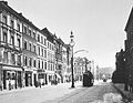
Aachener Strasse - corner of Brabanter Strasse (May 1903)

Aachener Strasse - Corner of Moltkestrasse (July 1903)
Aachener Straße - View towards Hahnentor by tram (around 1910)


From 1721 the house at Aachener Strasse No. 561 initially served as a stagecoach stop, where the mail to Aachen was prepared. The Austrian general, Count Clairfayt , moved with his troops after the battle of Königsdorf, won on October 5, 1794 against the Prussians, on October 6, 1794 via Aachener Strasse to reach Cologne at around 12 noon. The French under General Jean-Baptiste Jourdan advanced on the same day and occupied Cologne towards evening. An ink drawing by Joseph Michael Laporterie captures a balloon ride on June 29, 1795 and shows Aachener Straße from Hahnentor towards the west, as it leads through fields and pastures.
During the French period , Ferdinand Franz Wallraf was commissioned to design the new Melaten cemetery (no. 204) on the site of the former leprosy institute, which opened on June 29, 1810, based on the French "decree on the burials of June 12, 1804" ; the first funeral took place on July 1, 1810. Its builder Wallraf is also buried here.
.jpg)
Until May 1882 the Aachener Strasse was officially called "Aachener Chaussee". The front gardens decided by the city council on January 18, 1882 for the residential buildings on Aachener Strasse were withdrawn on July 6, 1882 as not being suitable for use as a shopping street. In the 19th century it was only well developed as far as Melaten, to the west of it it remained a tree-lined and poorly fortified road until 1888. Around 1900 there were few houses on the north side of Aachener Strasse in Braunsfeld, there were only numbers 350–390 and 444–520, and no. 503–505 was a steam mill. Müngersdorf had houses up to No. 852 (the city's beer tax registration office was located here). With the incorporation of Braunsfeld and Müngersdorf on April 1, 1888, the expansion of Aachener Strasse and its intensive development began. The contract concluded on July 19, 1882 between the city of Cologne and the horse-drawn tram operator Hard & Co. also included the route from the western city limits via Aachener Strasse, Hahnentorburg to Neumarkt . As early as November 1883, the medieval Bischofsweg was abandoned as the city boundary, which ran here at the level of Moltkestrasse. Since 1899 the Heinrich Scheele motor vehicle factory of Heinrich Scheele was located in No. 163 , which moved to Cologne-Bickendorf in 1927 .
Modern times

Aachener Str. - level with Brabanter Strasse
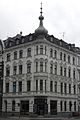
Aachener Straße - corner of Moltkestraße 65a (May 2013)

Aachener Strasse - View of the Moltkestrasse intersection towards Hahnentor (June 2011)
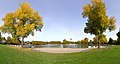
Aachener Straße - Aachener Weiher heading north (October 2012)

Aachener Straße 204 - main entrance to Melaten-Friedhof
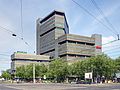
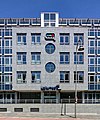
Aachener Strasse 300 - DKV / Ergo (April 2011)

Aachener Str. 458 - Clarenbach Church

Aachener Str. 561 - In the picture of Mary
Aachener Str. 746–750 - Unitymedia headquarters (June 2011)

Aachener Str. 1253 - Rhein-Center Cologne, Aachener Strasse in the foreground
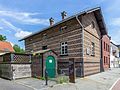
Aachener Str. 1328 - access to the Roman grave in Cologne-Weiden and the listed guard house (July 2016)


.jpg)


.jpg)


On August 17, 1912, line G began operating on the almost nine-kilometer stretch between Neumarkt via Aachener Strasse through Weiden to Lövenich. On December 6, 1918, around 55,000 British occupation soldiers marched in under the military governor Charles Fergusson via Aachener Strasse in the direction of Cologne. Previously, the withdrawal of the German troops took place here in November 1918. From 1920, on the initiative of Mayor Konrad Adenauer , the city began negotiations on the acquisition of larger land from private individuals and also from the community of Weiden-Lövenich on Aachener Strasse for the planned "Müngersdorf Sports Park", on September 22, 1921, the city council decided Cologne stadium construction for 15.4 million Reichsmarks; Construction began as early as October 1921. In addition to the main arena, an east and west arena, a cycling track and other facilities are planned on the 80 hectare area, which will not be completed at the opening ceremony on September 16, 1923. The "Sportpark Müngersdorf" was the largest German sports facility until the Olympic Stadium in Berlin was built in 1936. On March 23, 1924, construction began on the 42 hectare Aachener Weiher by Fritz Encke . The pond is hydrologically connected to the Lindenthal Canal and is the head piece of a canal axis that connects the interior with the outer green belt . The Church of St. Magdalena and Lazarus, built on the western Melaten site in 1245 and later rebuilt, was destroyed on May 31, 1942 during World War II. Since 29 May 1945 goes Frechener railway from the station Frechen through the urban forest with steam to the station Brown field at the Aachener Strasse. Architect Wilhelm Koep designed the semi-permanent winter building of the Williams Circus (" Williamsbau "), inaugurated in July 1947, at the Aachener Weiher (132) on the north side of Aachener Strasse, which until 1955 also served as a multi-purpose hall (carnival meetings). With a capacity of 2500 spectators, it was Cologne's largest post-war hall. Your name Aachener Straße provides orientation work by pointing exactly in the direction of its name. During the time of National Socialism , her name happened to correspond to the naming principles 1939, § 3, f) (3):
- “For streets that lead to neighboring communities, the name of the neighboring community is usually to be chosen. Important roads can be named according to their traffic significance after the place or the direction in which they lead. "
The City of Cologne installed the first traffic lights in Cologne on June 19, 1950 at the Aachener Strasse / Moltkestrasse intersection . The Clarenbach Church was opened on December 23, 1951. From the rubble of 17.457 million cubic meters a hilly landscape ("Aachener Berg") was created at the Aachener Weiher by September 1955. In 1970, DKV Deutsche Krankenversicherung moves into its main office, designed as an open-plan office and consisting of seven polygonal tower elements, at Aachener Straße 300 (the tower was raised to 18th floors in 2001, the building was expanded in 2005). On September 25, 1999, a funeral procession with the coffin of the deceased Willy Millowitsch led from Neumarkt across Aachener Strasse past the theater to Melaten, where the funeral took place.
Buildings and landmarks
The Millowitsch theater found after several moves on October 16, 1936, the premiere of the farce "maid of all work" a fixed location in 1905 established "Colonia-Haus" (no. 5) with a hall for 440 people. The building has belonged to the Freie Volksbühne Köln association since 1960 . The corner house No. 57 in the neo-renaissance style dates from 1890 and has seven axes. At the corner of Moltkestrasse 65a there is a residential and commercial building with a striking corner tower. The Cologne music station "674FM" (maintained by its sponsoring association "Radio 114 eV") has been broadcasting a 24-hour music program (114) as internet radio since May 30, 2013 , followed by EUROPA Versicherung (Aachener Strasse / corner Piusstrasse 137), the main entrance of the Melaten cemetery opens onto Aachener Strasse (204). Ergo insurance (300) follows after the Lindenthal Citizens' Registration Office (220 ). Since September 8, 1953, the main location of the record label Electrola has been at Maarweg 149–161, with headquarters and recording studios (1956), which are now operated by a different owner after the move of Electrola. This is followed by the Trinity Hospital in Cologne , which opened in 1909 (445–449) and the Clarenbach Church (458). The restaurant Im Marienbild (561) has existed since 1721 and is one of the first buildings on Aachener Strasse in Braunsfeld. The building initially served as a stagecoach stop, a village school was housed here from 1880–1882, the current building dates from 1883. The residential and commercial building (567) was built around 1914, the Bank-Verlag (Wendelinstrasse 1) founded in 1961 has been located here since 2000 Since 2005 the headquarters of the largest German cable network operator Unitymedia has been in 746–750 . The Rheinenergiestadion, the successor to the “Sportpark Müngersdorf”, is officially numbered 999. Between January 1988 and June 2010, RTL Television's broadcasting center was located in No. 1044 , which then moved to the Rheinhallen . The Rhein-Center Cologne (1253) in Cologne-Weiden, which opened on March 9, 1972, is the largest shopping center in Cologne with 180 shops on a sales area of 40,000 m² with 25,000 visitors daily.
Location and importance
Its name refers to the geographical orientation of the street to the west towards Aachen. Aachener Strasse is one of the busiest arterial roads in Cologne, crosses the districts of Köln-Neustadt-Süd , Köln-Braunsfeld , Köln-Junkersdorf , Köln-Lindenthal , Köln-Müngersdorf and ends in Köln-Weiden and divides the districts of Köln-Neustadt -Nord and Cologne-Neustadt-Süd . It is part of the federal road 55 ( ![]() ), which leads from Rheda-Wiedenbrück to Jülich . After Venloer Straße , the partly 3-lane Aachener Straße with the house number 1420 has the second highest house number in Cologne.
), which leads from Rheda-Wiedenbrück to Jülich . After Venloer Straße , the partly 3-lane Aachener Straße with the house number 1420 has the second highest house number in Cologne.
At first it runs as a one-way street towards the west, both directions start or end at the Aachener Weiher. The eastbound carriageway runs from there over Richard-Wagner-Straße, this also applies to the Cologne light rail route . Their lines 1 and 7 lead over Aachener Straße. Despite its considerable length of 8.7 km, it is not the longest street in the city. The longest street in Cologne is the military ring road with 21 km. It is one of the three arterial roads in Cologne that still start from existing archways. As an arterial road, it serves commuter traffic between the city center and the western districts and suburbs.
In the radial road lead major intersections: Brabant Street / Händelstraße and Brussels Road allow access to the Belgian Quarter . Here are Moltkestraße, interior Kanalstraße , Oskar-Jäger-Straße / Abbey Road, Melaten- and Stadtwaldgürtel , Maarweg / Kitschburger street Eupener Straße / Vincenz-Statz Street, Militärringstraße, Vogelsanger Weg and the junction Köln-Lövenich to the Köln-West ( Cologne motorway ring ).
In the area of the intersection with Moltkestrasse, Aachener Strasse is crossed by the Left Rhine route . In the course of the realization of the Cologne S-Bahn-Westring, the stop at Köln Aachener Straße is to be built there, which will create a transfer connection between the new S-Bahn and the tram lines 1 and 7.
Web links
Individual evidence
- ↑ Peter Fuchs (Ed.): Chronik zur Geschichte der Stadt Köln , Volume 1, 1991, pp. 32–33
- ↑ Böhlau Verlag (Ed.): Bonner Jahrbücher , Volume 208, 2008, p. 289
- ↑ Susanne Willer: Roman grave structures of the 2nd and 3rd centuries AD in the Rhine area , 2005, p. 79
- ^ Peter Schlüssel: Developments in the sphere of influence of the big city: illustrated using the example of the suburb of Lövenich near Cologne , 1972, p. 64
- ↑ Ludwig Röhrscheid: Rheinisches Archiv , Volume 103, 1977, p. 158
- ^ Ernest Wickersheimer : Eine Kölnische Lepraschau from 1357 , in: Sudhoffs Archiv , Volume 2, 1909, p. 434
- ^ A b Johannes Asen: The Melaten Leper House near Cologne. 1908, p. 23 f.
- ↑ Sigrid Schmitt , Michael Matheus : Crime and Society in the Late Middle Ages and Modern Times, 2005, p. 16 f.
- ↑ Franz Irsigler , Arnold Lassotta: beggars and jugglers, prostitutes and executioner, marginalized and outsiders in Cologne 1300-1600 , 1984, p 241
- ↑ beheaded on the Rabenstein and cut into four parts
- ^ Friedrich Everhard von Mering: History of the castles, manors, abbeys and monasteries in the Rhineland , Volumes 1-4, 1833, p. 151
- ↑ Peter Fuchs (Ed.): Chronik zur Geschichte der Stadt Köln , Volume 2, 1991, p. 95.
- ↑ A lively cannonade took place between Königsdorf and Junkersdorf
- ↑ Walther Zimmermann: Die Kunstdenkmäler des Rheinlands , Volume 23, 1978, p. 67
- ↑ Konrad Adenauer, Volker Gröbe: Lindenthal: The development of a Cologne suburb , 1988, p. 82
- ↑ Fred Kaufmann, Dagmar Lutz, Gudrun Schmidt-Esters: Cologne street names: Neustadt and Deutz , 1996, p. 13
- ↑ Peter Fuchs (Ed.): Chronicle of the History of the City of Cologne , Volume 2, 1991, p. 170.
- ↑ Peter Fuchs (Ed.): Chronik zur Geschichte der Stadt Köln , Volume 2, 1991, p. 360.
- ^ Marion Werner: Vom Adolf-Hitler-Platz zum Ebertplatz , 2008, p. 8
- ↑ Fred Kaufmann, Dagmar Lutz, Gudrun Schmidt-Esters: Cologne street names: Neustadt and Deutz. 1996, p. 21.
Coordinates: 50 ° 56 ′ 11.9 " N , 6 ° 55 ′ 38" E