
Collmberg
| Collmberg | ||
|---|---|---|
 View from the observation tower with a column of the Central European degree measurement |
||
| height | 312.8 m above sea level NHN | |
| location | Free State of Saxony , Germany | |
| Mountains | Collmback | |
| Coordinates | 51 ° 18 '13 " N , 13 ° 0' 38" E | |
|
||
| rock | Greywacke | |
| Age of the rock | Ordovician | |
| particularities | * Albert Tower ( AT ) | |

The Collmberg (Slavic name; cf. Sorbian chołm - "hill, hilltop") is the highest point in the northern Saxony district . It was also called Spielberg until the 19th century . Another earlier name is Oschatzer Collm . It is 312.8 m above sea level. NHN high and represents a landmark in the Wermsdorf Forest . The mountain is located about 6 kilometers west of Oschatz near the village of Collm . Depending on the map material used and the reference point, you will find different information on the height. Before 1945, the height on OLEX car maps was given as 314 m. On maps published after 1990, the height information varies between 312 and 318 m.
geology
The rock of the Collmberg consists of more than 500 million year old greywacke from the Ordovician , as well as quartzites and conglomerates . The current shape of the mountain originated in the Pleistocene . The oldest known rock in northern Saxony is on the surface at Collmberg. The Grauwacken can be followed over the neighboring mountains in an east-northeast direction to the Bornaer Weinberg and the Käferberg near Zaußwitz .
With the one kilometer east located Windmühlenberg (251 m above sea level), which is also called "Kleiner Collm" or because of its shape "Spitzcollm", the Eichberg (175 m above sea level) north of Striesa and some less prominent elevations the Collmberg forms the Collmrücke.
vegetation
The Collmberg is forested, the main tree species are red beech , English oak , sessile oak and conifers. The shrub layer consists mainly of buckthorn , mountain ash and elder . The flora in the soil shows ferns and mosses in damp places, and grasses and willows in dry grass .
meteorology
The Collmberg is a local weather divide. The Oschatz chronicler Carl Samuel Hofmann reported in 1817: The country people use the Collm as a weather vane. For as long as the top of the hill is foggy, even when the sky is clear, the weather will never be consistently good. The Collmberg smokes tobacco, the farmer then says ... The mountain is also usually a drain for the villages on the morning side, because almost all the thunderstorms and castle weather rising from the evening share above its summit.
history
On the mountain there is a medieval rampart (archaeological dating approx. 900/930), about the history of which there are no records. In addition to a ring wall with a diameter of 200 meters by 100 meters, which surrounds the entire dome, there are another three walls on the western mountain slope.
Another rampart, the old castle , is located between Collm and the Hubertusburg .
The Collmberg was not, as is often claimed, the site of the Meissnian state parliament in 1198 (" Landding "), but it was the 1000-year-old linden tree in the village of Collm , which lies on its southern slope.
On the occasion of the 60th anniversary of the reign of King Friedrich August I , the mountain was chosen in 1823 as the location of a national monument in which a bust of the king was to be erected. When the real purpose of the establishment, namely the homage to himself, became known to the king, he refused.
In 1827, after the king's death, an association was set up to erect a monument that collected donations across the country. The royal seat of Dresden was chosen as the location for the monument created by Ernst Rietschel in 1828 .

Draft for the national monument: view and floor plan
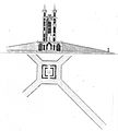
Draft for the national monument: view and floor plan


The Albert Tower was opened in 1854, and in 1932 the geophysical observatory of the University of Leipzig, relocated to the Collmberg, began work.
After 1945 the Collm was declared a military security zone. The abandoned mountain restaurant had to be demolished in 1967.

Albert Tower
As early as 1629, Elector Johann Georg I (Saxony) wanted to have a two-storey square tower eight meters long and 20 meters high built on the Collm, but the Thirty Years War prevented its construction. Around 1840 a flying beer bar was built on the Collmberg, which the restaurateur Lettau from Calbitz maintained with the help of a team of donkeys. A few years later, the same innkeeper built a mountain inn with government approval. In order to make the ascent to the mountain even more attractive for hikers, there was no tower that would allow a panoramic view of the country despite the tall trees. When the Meißen writer Julius Hofmann climbed the mountain in the summer of 1851, he lamented the lack of a lookout tower with the following verse: But here on the mountain's summit, leafy treetops prevented the spying spirit from seeing!
The 18-meter-high Albert Tower was built in 1853 and released for climbing on April 24, 1854 by a tower building committee . Since then it has served as a lookout tower . It was named after the then prince and duke, who later became King Albert of Saxony . It consists of three floors. 99 steps lead to an outside staircase, which is only continued on the last floor inside the tower to the viewing platform. The tower allows views of the Wermsdorf Forest and the Dahlener Heide , as well as the Petersberg near Halle , Hartenfels Castle in Torgau , the Völkerschlachtdenkmal and the city skyscraper in Leipzig , the Augustusburg , the Lilienstein in Saxon Switzerland and the Landeskrone near Görlitz . In 2002, two boards with the inscription Augustusburg 57 kilometers and Auersberg 110 kilometers were attached to the roofing .
On the south side of the viewing platform of the Albert Tower is a columnar granite pillar with the inscription Royal Saxon Station of the Central European Degree Measurement 1865 , which is reminiscent of the Central European Degree Measurement 1865 , in which the Collm was a first-order point for the Saxon triangular network. On this occasion a heliotrope was used from the tower to aim for the Fichtelberg (Ore Mountains), almost 100 kilometers south .
In the early 1990s, the Albert Tower had become dilapidated. The state enterprise Sachsenforst closed it in 1994, put in new steel girders and put in a new concrete surface. After the NPD had expressed its intention to purchase the tower, the municipality of Wermsdorf bought the tower from the Saxon state enterprise for real estate and construction management for 300 euros in December 2010. Today, the tower is a popular national hiking and excursion destination.
Geophysical observatory
Between 1927 and 1932, with funds from the American Rockefeller Foundation, a new building for the geophysical observatory of the University of Leipzig , which had existed since 1902, was built on the Collmberg and opened in 1932. In 1935 the observatory was expanded to include a seismographic station. Since then, a complete earthquake registration has been carried out using seismographs and the wind speed of the high atmosphere has been measured. The first scientific director of the facility was Ludwig Weickmann . From 1936 to 1937, Heinz Lettau constructed a mechanically coupled horizontal pendulum to measure the inclinations of the earth's surface. The measurements played a role in the seismographic evidence of the theory of a German atomic bomb test on October 2, 1944.
Worldwide earthquakes from magnitude 4.8 on the Richter scale can be registered in the observatory on the Collmberg . At the beginning of the 1990s, a regional network of sixteen similarly equipped measuring points was set up, to which the Collmer station has belonged since 1993. Due to the high sensitivity of the Collmer seismograph, ground movements of a millionth of a millimeter can be evaluated. These include underground explosions, quarry blasting or mountain falls.
To measure the wind speed, the field strength of three receivers located next to each other for the signals of the long-wave radio transmitter on 177 kHz ( Zehlendorf transmitter ), Radio Polonia on 225 kHz ( Solec Kujawski ) and from Radiojurnal from Topolná (Czech Republic) on 270 kHz are measured and based on the measured values Flow velocities in the high atmosphere closed.
Radio stations
In 1960 a radio tower was built on the mountain . The 90 meter (64 meter without antenna mast) high directional radio tower became known as the VHF transmitter Oschatz . In 2004, a second, 100-meter-high radio tower was built on the Collmberg , which, unlike the one built in 1960, does not have any high-altitude operating rooms. The now superfluous old radio tower was dismantled in May 2005. There are also on the Collmberg amateur radio - relay stations DB0SAX and DM0SAX.
More buildings
In addition to the Albert Tower, the Collmberg was built with a residential building, a farm building, a hall for concerts and an inn with a hall and ancillary rooms. In the vicinity of the tower there was also an enclosure with deer, deer and rabbits.
literature
- Frank Hörügel: The Collm - all of Northern Saxony looks at this mountain . In: Leipziger Volkszeitung . online and with this heading in the LVZ print edition Muldental, January 16, 2017, full-page article as "Topic of the day", p. 27.
Web links
- Geophysical observatory
- Old radio tower Collmberg. In: Structurae
- New radio tower Collmberg. In: Structurae
Individual evidence
- ↑ a b Map services of the Federal Agency for Nature Conservation ( information )
- ↑ Heinz Wicher: The highest elevation Collm or Collmberg? In: Leipziger Volkszeitung - Oschatzer Allgemeine. Oschatz, July 18, 2006, p. 16.
- ↑ Siegfried Reichel: Heimatfreund and local writer Siegfried Reichel reports on the first mention of the place Collm 820 years ago (part 3) . In: Leipziger Volkszeitung - Oschatzer Allgemeine . Oschatz August 2, 2005, p. 16 .
- ↑ a b The Collm. Retrieved October 27, 2015 .
- ^ Kurt Pietzsch: Geology of Saxony . Ed .: Deutscher Verlag der Wissenschaften. Berlin 1962.
- ↑ Karl Czischka: Once a dense forest belt. Royal chamber property. The observatory. The Spitzcollm . In: Leipziger Volkszeitung - Oschatzer Allgemeine . Oschatz November 23, 1999, p. 16 .
- ↑ Gottfried Massanek: A little wind ... in the Oschatz weather station. 1990, p. 112, quoted in Manfred Müller: That was Der Rundblick. 1954 to 1990. Sax Verlag, Beucha, ISBN 978-3-86729-054-8 , p. 473.
- ↑ a b c d e Siegfried Reichel: Heimatfreund and local chronicler Siegfried Reichel from Collm on the history of the stone landmark. On April 24th, the Albert Tower on the Collm celebrated its 150th birthday. Sandstone and greywacke. Granite pillars for surveyors. Horn sound and joy of singing. In: Leipziger Volkszeitung - Oschatzer Allgemeine. Oschatz, April 30, 2004, p. 28.
- ↑ Walther Käseberg: The Albert Tower on the Collm is a hundred years old. In: The panorama. 1960, p. 191, quoted in Manfred Müller: That was Der Rundblick. 1954 to 1990. Sax Verlag, Beucha 2009, ISBN 978-3-86729-054-8 , p. 71.
- ↑ a b Christdore Wetzig: With a height of 314 meters, the wooded Collm near Oschatz has always been attractive. Landmark of Northwest Saxony. In: Leipziger Volkszeitung - Oschatzer Allgemeine. Oschatz, May 6, 2006, p. 14.
- ^ Albert tower on the website of Wermsdorf
- ↑ Unspecified : A hike worth imitating from Oschatz-Rechau to Collm. In: Leipziger Volkszeitung - Oschatzer Allgemeine. June 12, 2001, p. 16.
- ↑ lga: Albert Tower sold. In: Leipziger Volkszeitung - Oschatzer Allgemeine. Oschatz, December 15, 2010, p. 1.
- ^ German Geophysical Society eV: Ludwig F. Weickmann (182 - 1961). In: Mitteilungen der Deutschen Geophysikalische Gesellschaft eV No. 3, Hanover 2007, (PDF, 3.92 MB) URL: ( online ( memento of the original from September 23, 2015 in the Internet Archive ) Info: The archive link was automatically inserted and not yet Checked. Please check the original and archive link according to the instructions and then remove this note .; PDF; 4.1 MB), accessed on February 25, 2011.
- ↑ a b c Hagen Rösner: Geophysical observatory on the Collm for 70 years in operation. Rector and Leipzig's OBM visiting. .Goerdeler's signature again on the collm. In: Leipziger Volkszeitung - Oschatzer Allgemeine. Oschatz, December 17, 2002, p. 13.
- ↑ Unspecified : The new earthquake station on the Collm. Alma Mater Lipsiensis 1409–2009, Leipzig, (PDF 99 kB), ( online ; PDF; 102 kB), accessed on March 5, 2011.
- ^ Michael Börngen, Franz Jacobs, Ludwig A. Weickmann: Ludwig F. Weickmann (1882–1961). In: Deutsche Geophysikalische Gesellschaft eV, No. 2, 2007, Hanover, (PDF 3.74 MB), ( online ( memento of the original from September 23, 2015 in the Internet Archive ) Info: The archive link was inserted automatically and has not yet been checked. Please check the original and archive link according to the instructions and then remove this note .; PDF; 4.1 MB), p. 9, accessed on March 5, 2011.
- ↑ Marcus Landschulze: Geophysical evaluation of large explosive device tests in October 1944 and March 1945. In: Rainer Karlsch, Heiko Petermann (ed.): For and against "Hitler's bomb". Studies on atomic research in Germany. Waxmann Verlag, Münster 2007, ISBN 978-3-8309-1893-6 , pp. 141 ff. (Online) , accessed on March 5, 2011.
- ↑ a b Christdore Wetzig: 70 years of the Geophysical Observatory Collm. History from homeland friend Christdore Wetzig 1931: Most modern institute in the world. In: Leipziger Volkszeitung - Oschatzer Allgemeine. Oschatz, May 14, 2002, p. 16.
- ↑ DL1XM: Collmberg / Saxony Relay DB0SAX. (No longer available online.) Archived from the original on August 9, 2015 ; accessed on October 28, 2015 . Info: The archive link was inserted automatically and has not yet been checked. Please check the original and archive link according to the instructions and then remove this notice.
- ↑ DL1XM, DG1LZG: 10m FM relay DM0SAX in Saxony. (No longer available online.) Archived from the original on September 9, 2015 ; accessed on October 28, 2015 . Info: The archive link was inserted automatically and has not yet been checked. Please check the original and archive link according to the instructions and then remove this notice.