
Andelu
| Andelu | ||
|---|---|---|
.svg)
|
|
|
| region | Île-de-France | |
| Department | Yvelines | |
| Arrondissement | Saint-Germain-en-Laye | |
| Canton | Aubergenville | |
| Community association | Gally Mauldre | |
| Coordinates | 48 ° 53 ′ N , 1 ° 50 ′ E | |
| height | 111-133 m | |
| surface | 3.96 km 2 | |
| Residents | 476 (January 1, 2017) | |
| Population density | 120 inhabitants / km 2 | |
| Post Code | 78770 | |
| INSEE code | 78013 | |
| Website | http://www.mairie-andelu78.fr/ | |
 Andelu Town Hall |
||

Andelu is a commune with 476 inhabitants (at January 1, 2017) in the department of Yvelines in the region Ile-de-France . It belongs to the arrondissement of Saint-Germain-en-Laye and the canton of Aubergenville (until 2015: canton of Guerville ). The inhabitants are called Andelusia .
geography
Andelu is located about 30 kilometers northwest of Versailles and covers an area of 396 hectares. Neighboring communities are:
- Maule in the north,
- Montainville in the east,
- Marcq in the southeast,
- Thoiry in the south,
- Goupillières in the southwest and
- Jumeauville in the northwest.
Population development
| year | 1962 | 1968 | 1975 | 1982 | 1990 | 1999 | 2006 | 2011 |
| Residents | 190 | 231 | 246 | 272 | 346 | 370 | 461 | 485 |
Attractions
- Chapelle de la Nativité-de-Notre-Seigneur (17th century chapel)
- Monument aux morts (Memorial to the Andelu War Victims)
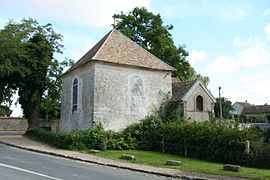
Chapelle de la Nativité-de-Notre-Seigneur
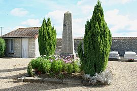
Fallen memorial


literature
- Le Patrimoine des Communes des Yvelines. Volume 1, Flohic Editions, Paris 2000, ISBN 2-84234-070-1 , pp. 231-232.
Web links
Commons : Andelu - collection of images, videos and audio files