
Jumeauville
| Jumeauville | ||
|---|---|---|
|
||
| region | Île-de-France | |
| Department | Yvelines | |
| Arrondissement | Mantes-la-Jolie | |
| Canton | Bonnières-sur-Seine | |
| Community association | Grand Paris Seine et Oise | |
| Coordinates | 48 ° 55 ' N , 1 ° 47' E | |
| height | 83-139 m | |
| surface | 7.77 km 2 | |
| Residents | 609 (January 1, 2017) | |
| Population density | 78 inhabitants / km 2 | |
| Post Code | 78580 | |
| INSEE code | 78325 | |
| Website | http://www.mairie-jumeauville.fr/ | |
 Jumeauville Town Hall |
||

Jumeauville is a French municipality with 609 inhabitants (at January 1, 2017) in the department of Yvelines in the region Ile-de-France . It belongs to the arrondissement of Mantes-la-Jolie and the canton of Bonnières-sur-Seine . The inhabitants are called Jumeauvillois .
geography
Jumeauville is located about 15 kilometers southeast of Mantes-la-Jolie and covers an area of 777 hectares. Neighboring communities are:
- Épône in the north,
- Maule in the east,
- Andelu in the southeast,
- Goupillières in the south,
- Hargeville in the southwest,
- Goussonville to the west and
- Mézières-sur-Seine in the north-west.
Toponymy
The name Jumeauville goes back to the name Gautmodvilla , which over time became Jumovilla and ultimately changed to Jumeauville .
Population development
| year | 1962 | 1968 | 1975 | 1982 | 1990 | 1999 | 2006 | 2011 |
| Residents | 340 | 346 | 354 | 552 | 532 | 554 | 582 | 584 |
Attractions
- Saint-Pierre-ès-Liens church from the 16th century
- Fontaine Saint-Pierre with Lavoir (fountain with a former public washing area; both from the 19th century)
- Monument aux morts (Memorial to the Jumeauville War Victims)

Saint-Pierre-ès-Liens church

War memorial

Fontaine Saint-Pierre with wash house
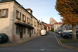
Town center


literature
- Le Patrimoine des Communes des Yvelines. Volume 1, Flohic Editions, Paris 2000, ISBN 2-84234-070-1 , pp. 264-267.
Web links
Commons : Jumeauville - collection of images, videos and audio files
- Monuments historiques (objects) in Jumeauville in the base Palissy of the French Ministry of Culture
- Population data and information about the municipality