
Cravent
| Cravent | ||
|---|---|---|
|
||
| region | Île-de-France | |
| Department | Yvelines | |
| Arrondissement | Mantes-la-Jolie | |
| Canton | Bonnières-sur-Seine | |
| Community association | Portes de l'Île-de-France | |
| Coordinates | 49 ° 0 ′ N , 1 ° 29 ′ E | |
| height | 105-167 m | |
| surface | 6.13 km 2 | |
| Residents | 438 (January 1, 2017) | |
| Population density | 71 inhabitants / km 2 | |
| Post Code | 78270 | |
| INSEE code | 78188 | |
 Mairie Cravent |
||

Cravent is a commune in the French department of Yvelines in the Ile-de-France . It belongs to the canton of Bonnières-sur-Seine in the arrondissement of Mantes-la-Jolie . It borders in the north-west on Villegats , in the north on Chaufour-lès-Bonnières , in the east on Lommoye , in the south on Villiers-en-Désœuvre and in the south-west on Breuilpont . The residents call themselves Craventais or Craventaises.
Attractions
- Military cemetery
- Castle of Cravent
- War memorial
- Church of the Trinity of the Virgin Mary and the Nativity ( Église de la Trinité-de-la-Vierge-et-de-la-Nativité )

Military cemetery

Castle of Cravent
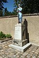
War memorial


Population development
| year | 1962 | 1968 | 1975 | 1982 | 1990 | 1999 | 2004 | 2009 | 2014 |
|---|---|---|---|---|---|---|---|---|---|
| Residents | 121 | 107 | 150 | 192 | 260 | 325 | 369 | 403 | 444 |
literature
- Le Patrimoine des Communes des Yvelines. Volume 1, Flohic Editions, Paris 2000, ISBN 2-84234-070-1 , pp. 101-102.
Web links
Commons : Cravent - collection of images, videos and audio files
- Monuments historiques (objects) in Cravent in the base Palissy of the French Ministry of Culture