
Flins-Neuve-Église
| Flins-Neuve-Église | ||
|---|---|---|
|
||
| region | Île-de-France | |
| Department | Yvelines | |
| Arrondissement | Mantes-la-Jolie | |
| Canton | Bonnières-sur-Seine | |
| Community association | Pays Houdanais | |
| Coordinates | 48 ° 53 ' N , 1 ° 35' E | |
| height | 119-134 m | |
| surface | 1.23 km 2 | |
| Residents | 156 (January 1, 2017) | |
| Population density | 127 inhabitants / km 2 | |
| Post Code | 78790 | |
| INSEE code | 78237 | |
 Mairie Flins-Neuve-Église |
||

Flins-Neuve-Église is a French municipality with 156 inhabitants (at January 1, 2017) in the department of Yvelines in the region Ile-de-France . The inhabitants are called Flinois .
geography
The village is located 48 kilometers west of Versailles , about 17 kilometers southwest of Mantes-la-Jolie and 13 kilometers north of Houdan . It lies on the southern border of the Mantois plateau and on the northern border of the Pays houdanais .
With an area of 1.23 km², the municipality is the smallest municipality in the Yvelines department. The place can only be reached via the D115 département road.
Attractions
- Saint-Denis church
- lock
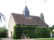
Saint-Denis church
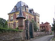
lock


literature
- Le Patrimoine des Communes des Yvelines. Volume 1, Flohic Editions, Paris 2000, ISBN 2-84234-070-1 , p. 306.
Web links
Commons : Flins-Neuve-Église - Collection of images, videos and audio files
- Monuments historiques (objects) in Flins-Neuve-Église in the base Palissy of the French Ministry of Culture