
Mules
| Mules | ||
|---|---|---|
.svg)
|
|
|
| region | Île-de-France | |
| Department | Yvelines | |
| Arrondissement | Mantes-la-Jolie | |
| Canton | Bonnières-sur-Seine | |
| Community association | Pays Houdanais | |
| Coordinates | 48 ° 48 ' N , 1 ° 37' E | |
| height | 93-129 m | |
| surface | 7.89 km 2 | |
| Residents | 972 (January 1, 2017) | |
| Population density | 123 inhabitants / km 2 | |
| Post Code | 78550 | |
| INSEE code | 78381 | |
 Maulette Town Hall |
||

Maulette is a French municipality with 972 inhabitants (as of January 1 2017) in the department of Yvelines in the region Ile-de-France . It belongs to the arrondissement of Mantes-la-Jolie and the canton of Bonnières-sur-Seine (until 2015: canton of Houdan ). The inhabitants are called Maulettois .
geography
Maulette is located about 55 kilometers west-southwest of Paris on Vesgre . Maulette is surrounded by the neighboring communities of Richebourg in the north, Bazainville in the east and northeast, Gambais in the east, Bourdonné in the south and southeast, Dannemarie in the south, Boutigny-Prouais in the southwest, Goussainville in the west and Houdan in the west and northwest.
The Route nationale 12 runs through the municipality.
Population development
| year | 1962 | 1968 | 1975 | 1982 | 1990 | 1999 | 2006 | 2013 |
| Residents | 345 | 380 | 510 | 699 | 705 | 712 | 752 | 840 |
| Source: Cassini and INSEE | ||||||||
Attractions
- Saint-Pierre church
- 15th century Saint-Nicolas church in Thionville
- Maulette Castle
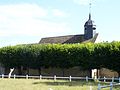
Saint-Pierre church

Maulette Castle


literature
- Le Patrimoine des Communes des Yvelines. Volume 1, Flohic Editions, Paris 2000, ISBN 2-84234-070-1 , pp. 321-323.
Web links
- Monuments historiques (objects) in Maulette in the base Palissy of the French Ministry of Culture