
Orgerus
| Orgerus | ||
|---|---|---|
.svg)
|
|
|
| region | Île-de-France | |
| Department | Yvelines | |
| Arrondissement | Mantes-la-Jolie | |
| Canton | Bonnières-sur-Seine | |
| Community association | Pays Houdanais | |
| Coordinates | 48 ° 50 ′ N , 1 ° 42 ′ E | |
| height | 77-186 m | |
| surface | 14.34 km 2 | |
| Residents | 2,370 (January 1, 2017) | |
| Population density | 165 inhabitants / km 2 | |
| Post Code | 78910 | |
| INSEE code | 78465 | |
| Website | http://www.orgerus.fr/ | |
 Town hall (Mairie) of Orgerus |
||

Orgerus is a French commune with 2,370 inhabitants (as of January 1 2017) in the department of Yvelines in the region Ile-de-France . It belongs to the arrondissement of Mantes-la-Jolie and the canton of Bonnières-sur-Seine (until 2015: canton of Houdan ). The inhabitants are called Orgerussiens .
geography
Orgerus is located about 60 kilometers west of Paris on the north-western edge of the forest of Rambouillet . Orgerus is surrounded by the neighboring communities of Saint-Martin-des-Champs in the north and north-east, Osmoy and Flexanville in the north-east, Béhoust in the east, Millemont in the south-east, Bazainville in the south and south-west, Tacoignières in the west and Prunay-le-Temple in the north-west.
Population development
| year | 1962 | 1968 | 1975 | 1982 | 1990 | 1999 | 2006 | 2012 |
| Residents | 884 | 1.012 | 1,457 | 2,004 | 2.184 | 2,245 | 2,324 | 2,340 |
Attractions
- Saint-Pierre-aux-Liens church from the 15th century, monument historique
- Remains of the Orgerus Castle
- Castles of Montplaisant and Les Ifs (both 18th century)
- Wash house
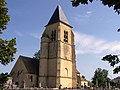
Saint-Pierre-aux-Liens church

Les Ifs Castle


literature
- Le Patrimoine des Communes des Yvelines. Volume 1, Flohic Editions, Paris 2000, ISBN 2-84234-070-1 , pp. 329-331.