
Béhoust
| Béhoust | ||
|---|---|---|
|
||
| region | Île-de-France | |
| Department | Yvelines | |
| Arrondissement | Rambouillet | |
| Canton | Aubergenville | |
| Community association | Cœur d'Yvelines | |
| Coordinates | 48 ° 50 ' N , 1 ° 43' E | |
| height | 88-171 m | |
| surface | 5.34 km 2 | |
| Residents | 460 (January 1, 2017) | |
| Population density | 86 inhabitants / km 2 | |
| Post Code | 78910 | |
| INSEE code | 78053 | |
| Website | http://www.behoust.fr | |
 Town hall (Mairie) of Béhoust |
||

Béhoust is a commune of 460 inhabitants (as of January 1 2017) in the Yvelines department in the region Ile-de-France . It belongs to the arrondissement of Rambouillet and the canton of Aubergenville (until 2015: canton of Montfort-l'Amaury ). The inhabitants are called Béhoustiens .
geography
Béhoust is 22 kilometers north-northwest of Rambouillet . The neighboring communities of Béhoust are Flexanville in the north and northeast, Garancières in the east, Millemont in the south and southeast and Orgerus in the west.
Population development
| year | 1793 | 1821 | 1841 | 1861 | 1881 | 1901 | 1921 | 1946 | 1962 | 1968 | 1975 | 1982 | 1990 | 1999 | 2006 | 2013 |
|---|---|---|---|---|---|---|---|---|---|---|---|---|---|---|---|---|
| Residents | 148 | 242 | 275 | 303 | 235 | 259 | 269 | 220 | 216 | 234 | 264 | 282 | 322 | 374 | 453 | 481 |
From 1962 only residents with primary residence
Attractions
See also: List of Monuments historiques in Béhoust
- 12th century Saint-Hilaire church
- Béhoust castle from the 18th century, monument historique since 1976
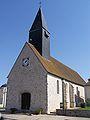
Saint-Hilaire church

Béhoust Castle


literature
- Le Patrimoine des Communes des Yvelines. Flohic Editions, Volume 2, Paris 2000, ISBN 2-84234-070-1 , pp. 567-568.
Web links
Commons : Béhoust - collection of images, videos and audio files