
Saint-Forget
| Saint-Forget | ||
|---|---|---|
.svg)
|
|
|
| region | Île-de-France | |
| Department | Yvelines | |
| Arrondissement | Rambouillet | |
| Canton | Maurepas | |
| Community association | Haute Vallée de Chevreuse | |
| Coordinates | 48 ° 42 ′ N , 2 ° 0 ′ E | |
| height | 77-168 m | |
| surface | 6 km 2 | |
| Residents | 518 (January 1, 2017) | |
| Population density | 86 inhabitants / km 2 | |
| Post Code | 78720 | |
| INSEE code | 78548 | |
 Town hall (Mairie) of Saint-Forget |
||

Saint-Forget is a French municipality with 518 inhabitants (as of January 1 2017) in the department of Yvelines in the region Ile-de-France . It belongs to the arrondissement of Rambouillet and the canton of Maurepas (until 2015: canton of Chevreuse ). The inhabitants are called Féréoliens .
geography
The municipality is part of the Haute Vallée de Chevreuse Regional Nature Park . Saint-Forget is located about 29 kilometers west-southwest of Paris and is surrounded by the neighboring municipalities of Le Mesnil-Saint-Denis in the north and northwest, Saint-Lambert in the north and northeast, Chevreuse in the east, Choisel in the south and Dampierre-en-Yvelines in the south and west.
Population development
| year | 1962 | 1968 | 1975 | 1982 | 1990 | 1999 | 2006 | 2013 |
| Residents | 273 | 235 | 290 | 370 | 458 | 521 | 484 | 477 |
| Source: Cassini and INSEE | ||||||||
Attractions
See also: List of Monuments historiques in Saint-Forget
- Saint-Ferréol church from the 12th century, rebuilt in the 14th and 17th centuries
- Mauvières Castle from the 17th / 18th centuries century

Saint-Ferréol church
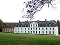
Mauvières Castle


literature
- Le Patrimoine des Communes des Yvelines. Volume 1, Flohic Editions, Paris 2000, ISBN 2-84234-070-1 , pp. 191-192.