Orsonville
| Orsonville | ||
|---|---|---|
|
|
||
| region | Île-de-France | |
| Department | Yvelines | |
| Arrondissement | Rambouillet | |
| Canton | Rambouillet | |
| Community association | Rambouillet Territoires | |
| Coordinates | 48 ° 29 ′ N , 1 ° 50 ′ E | |
| height | 140-159 m | |
| surface | 9.61 km 2 | |
| Residents | 334 (January 1, 2017) | |
| Population density | 35 inhabitants / km 2 | |
| Post Code | 78660 | |
| INSEE code | 78472 | |
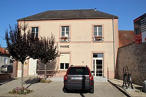
 Mairie (Town Hall) of Orsonville |
||
Orsonville is a French municipality with 334 inhabitants (as of January 1 2017) in the department of Yvelines in the region Ile-de-France . It belongs to the arrondissement of Rambouillet and the canton of Rambouillet (until 2015: canton of Saint-Arnoult-en-Yvelines ). The inhabitants are called Orsonvillois .
geography
Orsonville is about 54 kilometers southwest of Paris and about 18 kilometers south of Rambouillet . Orsonville is surrounded by the neighboring communities of Prunay-en-Yvelines in the north, Ablis in the north and northeast, Boinville-le-Gaillard in the east and northeast, Paray-Douaville in the southeast, Aunay-sous-Auneau in the south and Auneau in the west.
The Route nationale 191 runs along the eastern edge of the municipality .
Population development
| year | 1962 | 1968 | 1975 | 1982 | 1990 | 1999 | 2006 | 2013 |
| Residents | 242 | 244 | 231 | 253 | 255 | 240 | 299 | 338 |
| Source: Cassini and INSEE | ||||||||
Attractions
See also: List of Monuments historiques in Orsonville
- Saint-André church from the 12th century, monument historique since 1939
- Gauvilliers fort from the 15th century, monument historique since 1969
literature
- Le Patrimoine des Communes des Yvelines. Flohic Editions, Volume 2, Paris 2000, ISBN 2-84234-070-1 , pp. 781-783.


