
Lévis-Saint-Nom
| Lévis-Saint-Nom | ||
|---|---|---|
.svg)
|
|
|
| region | Île-de-France | |
| Department | Yvelines | |
| Arrondissement | Rambouillet | |
| Canton | Maurepas | |
| Community association | Haute Vallée de Chevreuse | |
| Coordinates | 48 ° 43 ' N , 1 ° 57' E | |
| height | 103-174 m | |
| surface | 8.25 km 2 | |
| Residents | 1,604 (January 1, 2017) | |
| Population density | 194 inhabitants / km 2 | |
| Post Code | 78320 | |
| INSEE code | 78334 | |
| Website | http://www.levis-saint-nom.fr/ | |
 Town hall of Lévis-Saint-Nom |
||

Lévis-Saint-Nom is a French commune with 1,604 inhabitants (at January 1, 2017) in the department of Yvelines in the region Ile-de-France . It belongs to the Arrondissement of Rambouillet and the Canton of Maurepas . The inhabitants are called Levissiens .
geography
Lévis-Saint-Nom covers an area of 825 hectares. The municipality is part of the Haute Vallée de Chevreuse Regional Nature Park . Neighboring communities are:
- Coignières in the north,
- Le Mesnil-Saint-Denis in the east,
- Dampierre-en-Yvelines to the south and
- Les Essarts-le-Roi to the west.
Population development
| year | 1962 | 1968 | 1975 | 1982 | 1990 | 1999 | 2006 | 2011 |
| Residents | 738 | 660 | 1,030 | 1,428 | 1,593 | 1,696 | 1,729 | 1,708 |
Attractions
See also: List of Monuments historiques in Lévis-Saint-Nom
- Saint-Nom-Notre-Dame church from the 13th century
- Château de La Cour Lévis (19th century castle)
- Notre-Dame de la Roche Abbey (17th century monastery)
- Château de La Boissière Beauchamp (19th century castle)
- Château de Crussol (castle from the 16th century; today only preserved as a ruin)

Abbaye Notre-Dame de la Roche
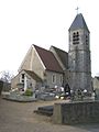
Saint-Nom-Notre-Dame church

Château de La Boissière Beauchamp


Personalities
- Guy I. de Lévis (around 1180–1233), knight and lord of Lévis-Saint-Nom
- Michel Fugain (born 1942), French singer
literature
- Le Patrimoine des Communes des Yvelines. Volume 1, Flohic Editions, Paris 2000, ISBN 2-84234-070-1 , pp. 181-182.
Web links
Commons : Lévis-Saint-Nom - Collection of images, videos and audio files