
Sainte-Mesme
| Sainte-Mesme | ||
|---|---|---|
|
||
| region | Île-de-France | |
| Department | Yvelines | |
| Arrondissement | Rambouillet | |
| Canton | Rambouillet | |
| Community association | Rambouillet Territoires | |
| Coordinates | 48 ° 32 ' N , 1 ° 58' E | |
| height | 96-162 m | |
| surface | 8.16 km 2 | |
| Residents | 939 (January 1, 2017) | |
| Population density | 115 inhabitants / km 2 | |
| Post Code | 78730 | |
| INSEE code | 78569 | |
 Mairie (Town Hall) of Sainte-Mesme |
||

Sainte-Mesme is a French municipality with 939 inhabitants (as of January 1 2017) in the department of Yvelines in the region Ile-de-France . It belongs to the arrondissement of Rambouillet and the canton of Rambouillet (until 2015: canton of Saint-Arnoult-en-Yvelines ). The inhabitants are called Sainte-Mesmins .
geography
Sainte-Mesme is located about 54 kilometers southwest of Paris and about 15 kilometers southeast of Rambouillet on the Orge River . Sainte-Mesme is surrounded by the neighboring communities of Saint-Arnoult-en-Yvelines in the north, Dourdan in the east and north-east, Corbreuse in the south and south-east, Saint-Martin-de-Bréthencourt in the south and west and Ponthévrard in the west and north-west.
The A10 car route runs along the north-western edge of the municipality .
Population development
| year | 1962 | 1968 | 1975 | 1982 | 1990 | 1999 | 2006 | 2013 |
| Residents | 525 | 554 | 557 | 741 | 814 | 866 | 841 | 911 |
| Source: Cassini and INSEE | ||||||||
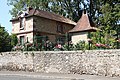
Attractions
- Church of Sainte-Mesme, Monument historique
- Sainte-Mesme Castle, Monument historique
- Sainte-Mesme mansion, historic monument

Saint-Mesme church
Sainte-Mesme Castle

Manor of Sainte-Mesme


Personalities
- Charles-François Lebrun (1739-1824), statesman
- Auguste Maquet (1813–1888), writer
literature
- Le Patrimoine des Communes des Yvelines. Flohic Editions, Volume 2, Paris 2000, ISBN 2-84234-070-1 , pp. 806-811.