Les Essarts-le-Roi
| Les Essarts-le-Roi | ||
|---|---|---|

|
|
|
| region | Île-de-France | |
| Department | Yvelines | |
| Arrondissement | Rambouillet | |
| Canton | Rambouillet | |
| Community association | Rambouillet Territoires | |
| Coordinates | 48 ° 43 ' N , 1 ° 54' E | |
| height | 115-181 m | |
| surface | 19.32 km 2 | |
| Residents | 6,708 (January 1, 2017) | |
| Population density | 347 inhabitants / km 2 | |
| Post Code | 78690 | |
| INSEE code | 78220 | |
| Website | http://www.essarts-le-roi.org/ | |
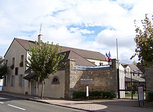
 Town hall of Les Essarts-le-Roi |
||
Les Essarts-le-Roi is a French municipality with 6708 inhabitants (at January 1, 2017) in the department of Yvelines in the region Ile-de-France . It belongs to the arrondissement of Rambouillet and the canton of Rambouillet . The inhabitants are called Essartois .
geography
The municipality is part of the Haute Vallée de Chevreuse Regional Nature Park . Neighboring municipalities of Les Essarts-le-Roi are Coignières in the north, Lévis-Saint-Nom in the northeast, Dampierre-en-Yvelines in the east, Senlisse in the southeast, Auffargis in the south, Le Perray-en-Yvelines in the southwest, Les Bréviaires in the west and Saint-Rémy-l'Honoré in the north-west.
Les Essarts-le-Roi is on the Paris – Brest railway line . The National Route 10 runs through the municipality .
The municipality consists of the main town of Saint-Hubert , Les Layes and Maison Neuve .
Population development
| year | 1962 | 1968 | 1975 | 1982 | 1990 | 1999 | 2006 | 2011 |
| Residents | 1,735 | 2,045 | 3,254 | 4,876 | 5,565 | 6.126 | 6.123 | 6,298 |
Attractions
- Saint-Corneille-Saint-Cyprien church
- Chapel des Layes
- Château de l'Artoire (castle)
Community partnerships
There is a partnership with the German municipality of Salem in Baden-Württemberg.
literature
- Le Patrimoine des Communes des Yvelines. Flohic Editions, Volume 2, Paris 2000, ISBN 2-84234-070-1 , pp. 715-720.
Web links
- Monuments historiques (objects) in Les Essarts-le-Roi in the Base Palissy of the French Ministry of Culture

