
Gambais
| Gambais | ||
|---|---|---|

|
|
|
| region | Île-de-France | |
| Department | Yvelines | |
| Arrondissement | Rambouillet | |
| Canton | Aubergenville | |
| Community association | Cœur d'Yvelines | |
| Coordinates | 48 ° 46 ′ N , 1 ° 40 ′ E | |
| height | 94-182 m | |
| surface | 23.02 km 2 | |
| Residents | 2,463 (January 1, 2017) | |
| Population density | 107 inhabitants / km 2 | |
| Post Code | 78950 | |
| INSEE code | 78263 | |
| Website | http://www.gambais.fr/ | |
 Town Hall (Mairie) of Gambais |
||

Gambais is a French commune with 2,463 inhabitants (as of January 1 2017) in the department of Yvelines in the region Ile-de-France . It belongs to the arrondissement of Rambouillet and the canton of Aubergenville (until 2015: canton of Houdan ). The inhabitants are called Gambaisiens .
geography
Gambais is located about 60 kilometers west of Paris on the northwestern edge of the Rambouillet forest and on the Vesgre river . The municipality is part of the Haute Vallée de Chevreuse Regional Nature Park . Gambais is surrounded by the neighboring communities of Bazainville in the north, Millemont in the northeast, Grosrouve in the east, Gambaiseuil in the east and southeast, Bourdonné in the south and Maulette in the west. Route nationale 12 runs along the northern edge of the municipality .
Population development
| year | 1962 | 1968 | 1975 | 1982 | 1990 | 1999 | 2006 | 2012 |
| Residents | 888 | 1,084 | 1,239 | 1,365 | 1,730 | 2,064 | 2,343 | 2,423 |
Attractions
See also: List of Monuments historiques in Gambais
- Saint-Aignan church, 10th century foundation, 1621 bell tower, historic monument since 1946
- Neuville Castle, built in the 16th century, restored in 1966, monument historique since 1972, 1970 film set for donkey skin .
- Bourdonné mill
- Wash house

Saint-Aignan church

Neuville Castle
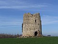
Bourdonné mill


Personalities
- Henri Désiré Landru (1869–1922), serial killer, lived in Gambais
- Robert Delaunay (1885–1941), painter, buried here
- François Feldman (* 1958), singer
literature
- Le Patrimoine des Communes des Yvelines. Volume 1, Flohic Editions, Paris 2000, ISBN 2-84234-070-1 , pp. 307-310.